Related Research Articles

The Sierra Nevada is a mountain range in the Western United States, between the Central Valley of California and the Great Basin. The vast majority of the range lies in the state of California, although the Carson Range spur lies primarily in Nevada. The Sierra Nevada is part of the American Cordillera, an almost continuous chain of mountain ranges that forms the western "backbone" of the Americas.

Sequoia National Park is an American national park in the southern Sierra Nevada east of Visalia, California. The park was established on September 25, 1890, and today protects 404,064 acres of forested mountainous terrain. Encompassing a vertical relief of nearly 13,000 feet (4,000 m), the park contains the highest point in the contiguous United States, Mount Whitney, at 14,505 feet (4,421 m) above sea level. The park is south of, and contiguous with, Kings Canyon National Park; both parks are administered by the National Park Service together as Sequoia and Kings Canyon National Parks. UNESCO designated the areas as Sequoia-Kings Canyon Biosphere Reserve in 1976.

The Black Rock Desert is a semi-arid region of lava beds and playa, or alkali flats, situated in the Black Rock Desert–High Rock Canyon Emigrant Trails National Conservation Area, a silt playa 100 miles (160 km) north of Reno, Nevada that encompasses more than 300,000 acres (120,000 ha) of land and contains more than 120 miles (200 km) of historic trails. It is in the northern Nevada section of the Great Basin with a lakebed that is a dry remnant of Pleistocene Lake Lahontan.

The Eskimo curlew, also known as northern curlew, is a species of curlew in the family Scolopacidae. It was one of the most numerous shorebirds in the tundra of western Arctic Canada and Alaska. Thousands of birds were then killed per year in the late 1800s. As there has not been a reliable sighting since 1987 or a confirmed sighting since 1963, the Eskimo curlew is considered Critically Endangered or possibly extinct. The bird was about 30 cm (12 in) long and fed mostly on insects and berries.
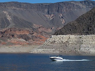
Lake Mead National Recreation Area is a U.S. national recreation area in southeastern Nevada and northwestern Arizona. Operated by the National Park Service, Lake Mead NRA follows the Colorado River corridor from the westernmost boundary of Grand Canyon National Park to just north of the cities of Laughlin, Nevada and Bullhead City, Arizona. It includes all of the eponymous Lake Mead as well as the smaller Lake Mohave – reservoirs on the river created by Hoover Dam and Davis Dam, respectively – and the surrounding desert terrain and wilderness.

The Colorado Plateau, also known as the Colorado Plateau Province, is a physiographic and desert region of the Intermontane Plateaus, roughly centered on the Four Corners region of the southwestern United States. This province covers an area of 336,700 km2 (130,000 mi2) within western Colorado, northwestern New Mexico, southern and eastern Utah, northern Arizona, and a tiny fraction in the extreme southeast of Nevada. About 90% of the area is drained by the Colorado River and its main tributaries: the Green, San Juan, and Little Colorado. Most of the remainder of the plateau is drained by the Rio Grande and its tributaries.

A hoodoo is a tall, thin spire of rock formed by erosion. Hoodoos typically consist of relatively soft rock topped by harder, less easily eroded stone that protects each column from the elements. They generally form within sedimentary rock and volcanic rock formations.
The Ruby Mountains are a mountain range, primarily located within Elko County with a small extension into White Pine County, in Nevada, United States. Most of the range is included within the Humboldt-Toiyabe National Forest. The range reaches a maximum elevation of 11,387 feet (3,471 m) on the summit of Ruby Dome. To the north is Secret Pass and the East Humboldt Range, and from there the Rubies run south-southwest for about 80 miles (130 km). To the east lies Ruby Valley, and to the west lie Huntington and Lamoille Valleys. The Ruby Mountains are the only range of an introduced bird, the Himalayan snowcock, in North America.

Bitterroot National Forest comprises 1.587 million acres (6,423 km2) in west-central Montana and eastern Idaho of the United States. It is located primarily in Ravalli County, Montana, but also has acreage in Idaho County, Idaho (29.24%), and Missoula County, Montana (0.49%).

Audubon Park is a municipal park located in the Uptown neighborhood of New Orleans, Louisiana, in the United States. It is approximately 350 acres. The park is approximately six miles to the west of the city center of New Orleans and sits on land that was purchased by the city in 1871. It is bordered on one side by the Mississippi River and on the other by St. Charles Avenue, directly across from Loyola University and Tulane University. The park is named in honor of artist and naturalist John James Audubon, who began living in New Orleans in 1821.
The National Outdoor Book Award (NOBA) was formed in 1997 as an American-based non-profit program which each year presents awards honoring the best in outdoor writing and publishing. It is housed at Idaho State University and chaired by Ron Watters. It is sponsored by the National Outdoor Book Awards Foundation, Idaho State University and the Association of Outdoor Recreation and Education. As of 2021, awards have been presented in 13 categories, although not all categories are awarded in any given year.

The Jawbone–Butterbredt Area of Critical Environmental Concern (ACEC), is located in the Mojave Desert and Southern Sierra Nevada, northwest of California City and California State Route 14, in Kern County, California.
The Little High Rock Canyon Wilderness is a US Wilderness Area in Nevada under the Bureau of Land Management. It is located south of the High Rock Canyon Wilderness and west of the High Rock Lake Wilderness.

The Mokelumne Wilderness is a 105,165-acre federally designated wilderness area located 70 miles (110 km) east of Sacramento, California. It is within the boundaries of three national forests: Stanislaus, Eldorado and Toiyabe. First protected under the Wilderness Act of 1964, the Mokelumne's borders were expanded under the California Wilderness Act of 1984 with the addition of 55,000 acres. The wilderness takes its name from the Mokelumne River, which was named after a Mi-wok Indian village located on the riverbank in California's Central Valley.

L. Martin Griffin, widely known as Marty Griffin, is an American environmentalist and conservationist in Northern California and author of the book Saving the Marin–Sonoma Coast. He has also been a doctor, director of the Sonoma Developmental Center, head of the Marin Audubon Society, board member of the Marin Municipal Water District, and owner of Hop Kiln Winery in Sonoma County.

The Trout Creek Mountains are a remote, semi-arid Great Basin mountain range mostly in southeastern Oregon and partially in northern Nevada in the United States. The range's highest point is Orevada View Benchmark, 8,506 feet (2,593 m) above sea level, in Nevada. Disaster Peak, elevation 7,781 feet (2,372 m), is another prominent summit in the Nevada portion of the mountains.

The Mount Adams Recreation Area is a 21,000-acre (8,500 ha) recreation area in the U.S. state of Washington managed by the Yakama Nation Tribal Forestry Program. The area encompasses an ecologically complex and geologically active landscape. The region features the most rugged side of Mount Adams, including canyons and the Great Gap section of the Mount Adams circumnavigation route, a three-mile trail-less section over two great canyons and many difficult glacial creeks. At 12,276 feet (3,742 m), Mount Adams is one of the major Cascade mountains. The recreation area is on the east side of the mountain and is part of the Yakama Indian Reservation and includes the popular Bird Creek Meadows area.

The End of Night: Searching for Natural Darkness in an Age of Artificial Light is a 2013 non-fiction book by Paul Bogard on the gradual disappearance, due to light pollution, of true darkness from the night skies of most people on the planet. Bogard examines the effects of this loss on human physical and mental health, society, and ecosystems, and how it might be mitigated.

Hell for Sure Lake is an Alpine lake located in the John Muir Wilderness, which is part of the Sierra Nevada mountain range. The lake is at an elevation of 10,768 feet (3,282 m), has a few small rocky islands and is between Red Mountain to the north and Mount Hutton to the south. The Hell for Sure trail and Hell for Sure Pass both are named after this lake with the region being known for its rough terrain. The rocks the surround Hell for Sure Lake and its nearby mountains are estimated to be over 100 million years old.

Kennedy Peak is a 10,718-foot-elevation (3,267 meter) mountain summit located in Tuolumne County, California, United States.
References
- ↑ "Paul Bogard | Faculty & Staff | Hamline University". www.hamline.edu.
- ↑ "2014 PEN/E. O. Wilson Literary Science Writing Award". PEN America. 2014-04-16. Retrieved 2022-07-11.
- ↑ "The End of Night by Paul Bogard – review". the Guardian. July 14, 2013.
- ↑ "Nonfiction Book Review: The Ground Beneath Us: From the Oldest Cities to the Last Wilderness, What Dirt Tells Us About Who We Are by Paul Bogard. Little, Brown, $27 (320p) ISBN 978-0-316-34226-1". PublishersWeekly.com.
- ↑ Paul, Bogard. "What if Night?". School Library Journal.
- ↑ "Review of What if Night?". www.forewordreviews.com. Retrieved 2022-07-11.
- ↑ Bogard, Paul (2021-06-18). "Where Are All the Wild Things, Daddy?". The New York Times. ISSN 0362-4331 . Retrieved 2022-07-11.
- ↑ "A New Golden Age of Observation Is Revealing the Wonders of Night Migration". Audubon. 2021-04-23. Retrieved 2022-07-11.