Related Research Articles

Crete is the largest and most populous of the Greek islands, the 88th largest island in the world and the fifth largest island in the Mediterranean Sea, after Sicily, Sardinia, Cyprus, and Corsica. Crete rests about 160 km (99 mi) south of the Greek mainland, and about 100 km (62 mi) southwest of Anatolia. Crete has an area of 8,450 km2 (3,260 sq mi) and a coastline of 1,046 km (650 mi). It bounds the southern border of the Aegean Sea, with the Sea of Crete to the north and the Libyan Sea to the south. Crete covers 260 km from west to east but is narrow from north to south, spanning three longitudes but only half a latitude.

Overbetuwe is a municipality in the province of Gelderland in the Netherlands. It was formed on 1 January 2001 as a merger of three former municipalities: Elst, Heteren and Valburg. Overbetuwe is bordered in the north by the river Rhine and in the south by the river Waal. The town hall is located in Elst, the largest town in the municipality. Since 2021 it has been part of the Arnhem-Nijmegen Green Metropolitan Region (Dutch: Groene Metropoolregio Arnhem-Nijmegen, which aids planning and development in the region's eighteen municipalities.
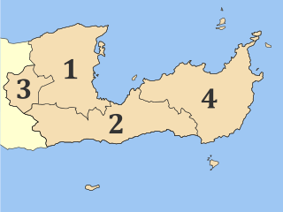
Lasithi is the easternmost regional unit on the island of Crete, to the east of Heraklion. Its capital is Agios Nikolaos, the other major towns being Ierapetra and Sitia. The mountains include the Dikti in the west and the Thrypti in the east. The Sea of Crete lies to the north and the Libyan Sea to the south.

Myrtos is a coastal village in the west of the municipality of Ierapetra, in the Regional Unit of Lasithi on the Greek island of Crete. It is located 50 km (31 mi) from Agios Nikolaos and 15 km (9.3 mi) from Ierapetra, on the road to Viannos. A little to the west of the village is the iconic conical Kolektos mountain. Myrtos is situated on the Libyan Sea. The patron saint of the village is Saint Anthony. The population of the village in 2010 was approximately 600 people.

Pyrgos is an archaeological site of the Minoan civilization near Myrtos in the municipality of Ierapetra on the south coast of Crete. Pyrgos provides evidence of settlements along the southern Ierapetra Isthmus. This site has had a long history due to its valuable location and geography. It is located close to the Myrtos valley and has a harbor with a nearby mountain range providing its protection. The settlement includes a courtyard, many rooms, a country house and a tomb.

Gournia is the site of a Minoan palace complex on the island of Crete, Greece, excavated in the early 20th century by the American archaeologist, Harriet Boyd-Hawes. The original name for the site is unknown. The modern name comes from the abundant hollow vessels found all over the site. Gournia lies in the municipality of Ierapetra in the prefecture of Lasithi.

Ierapetra is a Greek city and municipality located on the southeast coast of Crete.
Koutsouras (Κουτσουράς) is a village in Lasithi regional unit, in Crete, Greece 22 kilometers east of Ierapetra. Its population is 818. It was the headquarters of the municipality of Makry Gialos and is the biggest village in the region. Key economic activities include agriculture and tourism. It has nice beaches and a golf course is due to be built over the next five years. The coast is rocky and there are beautiful pebble beaches with crystal clear waters. Today it is the seat of Makry Gialos municipal unit and part of Ierapetra municipality.

Episkopi Ierapetras is a village on the Greek island of Crete. Episkopi belongs to the municipality of Ierapetra in the prefecture of Lasithi. It lies north of Ierapetra in the middle of the narrowest part of the island. The village has approximately one thousand inhabitants.

Spinalonga is an island located in the Gulf of Elounda in north-eastern Crete, in the municipality of Agios Nikolaos, Lasithi, next to the town of Plaka. The island is further assigned to the area of Kalydon. It is near the Spinalonga peninsula – which often causes confusion as the same name is used for both.

Gra Lygia is located approximately 4 km west of Ierapetra center. Its residents are called "GraLighiotes". They are occupied mainly in the agriculture sector; this is the main source of income for the residents and their income per capita is one of the highest in the region. The village is surrounded by greenhouses which demonstrates that the agriculture sector is modernized. There are many firms in related fields such as agriculture companies that co-operate with multinationals.

Thrypti is a mountain range in Lasithi in eastern Crete, Greece. It trends to the northeast from Ierapetra in the southwest in the direction of Sitia. However, it only goes half-way in that direction. The rest of the distance is completed by the distinct Ornon mountains, separated from the Thrypti by the Bebonas river valley, and the lower Western Siteia Foothills covering the space between the Ornon range and Sitia itself. The highest peak of Thrypti is Afentis, which is 1,476 m amsl. The three ranges constitute the West Sitia Mountains.

Males is a historic village in the municipality of Ierapetra in Lasithi prefecture on Crete. It is situated 25 kilometers north-west of Ierapetra, 40 from Agios Nikolaos and 12 kilometers away from the sea. Together with nearby hamlets Hristos and Metaxohori Males until recently formed the Nea Mala municipality. It is built 550 meters above sea level, south east of Dikti mountain, in an area rich in vegetation. It is built where the ancient city of Mala was.
Kato Symi is a small historic village of Crete, in Heraklion regional unit, 31 km (19 mi) from Ierapetra and 74 km (46 mi) from Heraklion city. Today it belongs to Viannos municipality and borders the Ierapetra municipality. It lies about 780 m (2,560 ft) above sea level, south of Mount Dikti in a verdant mountainous area, which is probably the most wooded of Crete. Near the village, at an altitude of 1,200 m (3,900 ft), lies the ancient sanctuary of Hermes and Aphrodite. It is dated from the middle Minoan period and had been used for worship for more than 1,000 years. Kato Simi has been destroyed three times, by Arabs, Turks and finally by the German army in World War II, when it was the center of resistance of the Viannos–Ierapetra area against the Nazi occupying forces.

The Viannos massacres were a mass extermination campaign launched by German forces against the civilian residents of around 20 villages located in the areas of east Viannos and west Ierapetra provinces on the Greek island of Crete during World War II. The killings, with a death toll in excess of 500, were carried out on 14–16 September 1943 by Wehrmacht units. They were accompanied by the burning of most villages, looting, and the destruction of harvests.

The Isthmus of Ierapetra is a strip of land on the Greek island of Crete which connects the easternmost municipality, Siteia, to the rest of the island. Its name comes from the largest settlement, Ierapetra (Ιεράπετρα), which is situated on the south coast.

O.F. Ierapetra Football Club, short for Omilos Filathlon Ierapetra and also simply known as OFI, is a Greek professional football club based in Ierapetra, Lasithi, Crete, Greece. The club was established in 1970, and its traditional colors are black and white. It is the oldest and most successful football club representing the town of Ierapetra, hometown of one of the greatest Cretan players of all time: Petros Vouzounerakis, of whom the club's home ground is named after.
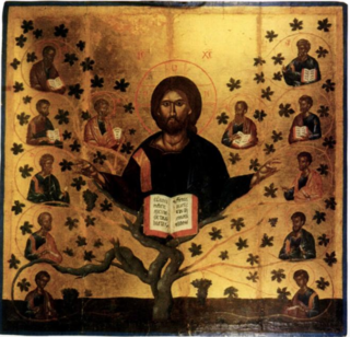
Christ the Vine is a tempera painting created by Greek painter Angelos. Angelos was active from 1425 to 1457. He was a teacher and protopsaltis. His students included some of the most famous painters of the early Cretan Renaissance. Andreas Pavias and Andreas Ritzos were his students and were heavily influenced by his style. Forty-nine of his works survived. Angelo’s Christ the Vine was one of his most important works.
Maria Lioudaki was a Greek educator, folklorist, and resistance fighter. She promoted social action in Lasithi with her friend, Maria Drandaki (1914–1947), with whom she was arrested and killed during the Greek Civil War.
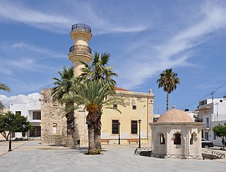
The Mosque of Ierapetra, formerly known as the Hamidiye Mosque, is a historical Ottoman mosque located in the town of Ierapetra, on the island of Crete, Greece. Like the other mosques in Crete, today it is not open for worship.
References
- ↑ Eleni Papadopouloy - Kontopodi, Apo tous anemofraktes sta thermokipia, I symbolh toy Pavlou Koupers.