Level of service (LOS) is a qualitative measure used to relate the quality of motor vehicle traffic service. LOS is used to analyze roadways and intersections by categorizing traffic flow and assigning quality levels of traffic based on performance measure like vehicle speed, density, congestion, etc. In a more general sense, levels of service can apply to all services in asset management domain.

A road surface, or pavement, is the durable surface material laid down on an area intended to sustain vehicular or foot traffic, such as a road or walkway. In the past, gravel road surfaces, hoggin, cobblestone and granite setts were extensively used, but these have mostly been replaced by asphalt or concrete laid on a compacted base course. Asphalt mixtures have been used in pavement construction since the beginning of the 20th century and are of two types: metalled (hard-surfaced) and unmetalled roads. Metalled roadways are made to sustain vehicular load and so are usually made on frequently used roads. Unmetalled roads, also known as gravel roads, are rough and can sustain less weight. Road surfaces are frequently marked to guide traffic.
A dipstick is one of several measurement devices.

Road surface marking is any kind of device or material that is used on a road surface in order to convey official information; they are commonly placed with road marking machines. They can also be applied in other facilities used by vehicles to mark parking spaces or designate areas for other uses. In some countries and areas, road markings are conceived as horizontal traffic signs, as opposed to vertical traffic signs placed on posts.
The pavement condition index (PCI) is a numerical index between 0 and 100, which is used to indicate the general condition of a pavement section. The PCI is widely used in transportation civil engineering and asset management, and many municipalities use it to measure the performance of their road infrastructure and their levels of service. It is a statistical measure and requires manual survey of the pavement. This index was originally developed by the United States Army Corps of Engineers as an airfield pavement rating system, but later modified for roadway pavements and standardized by the ASTM. The surveying processes and calculation methods have been documented and standardized by ASTM for both roads and airport pavements:
The Air Movement and Control Association International, Inc. (AMCA) is an American trade body that sets standards for Heating, Ventilation and Air Conditioning (HVAC) equipment. It rates fan balance and vibration, aerodynamic performance, air density, speed and efficiency.
Pavement management is the process of planning the maintenance and repair of a network of roadways or other paved facilities in order to optimize pavement conditions over the entire network.
Road surface textures are deviations from a planar and smooth surface, affecting the vehicle/tyre interaction. Pavement texture is divided into: microtexture with wavelengths from 0 mm to 0.5 millimetres (0.020 in), macrotexture with wavelengths from 0.5 millimetres (0.020 in) to 50 millimetres (2.0 in) and megatexture with wavelengths from 50 millimetres (2.0 in) to 500 millimetres (20 in).

A traffic count is a count of vehicular or pedestrian traffic, which is conducted along a particular road, path, or intersection. A traffic count is commonly undertaken either automatically, or manually by observers who visually count and record traffic on a hand-held electronic device or tally sheet. Traffic counts can be used by local councils to identify which routes are used most, and to either improve that road or provide an alternative if there is an excessive amount of traffic. Also, some geography fieldwork involves a traffic count. Traffic counts provide the source data used to calculate the Annual Average Daily Traffic (AADT), which is the common indicator used to represent traffic volume. Traffic counts are useful for comparing two or more roads, and can also be used alongside other methods to find out where the central business district (CBD) of a settlement is located. Traffic counts that include speeds are used in speed limit enforcement efforts, highlighting peak speeding periods to optimise speed camera use and educational efforts.

Crocodile cracking, also called alligator cracking and perhaps misleadingly fatigue cracking, is a common type of distress in asphalt pavement. The following is more closely related to fatigue cracking which is characterized by interconnecting or interlaced cracking in the asphalt layer resembling the hide of a crocodile. Cell sizes can vary in size up to 11.80 inches (300 mm) across, but are typically less than 5.90 inches (150 mm) across. Fatigue cracking is generally a loading failure, but numerous factors can contribute to it. It is often a sign of sub-base failure, poor drainage, or repeated over-loadings. It is important to prevent fatigue cracking, and repair as soon as possible, as advanced cases can be very costly to repair and can lead to formation of potholes or premature pavement failure.

The international roughness index (IRI) is the roughness index most commonly obtained from measured longitudinal road profiles. It is calculated using a quarter-car vehicle math model, whose response is accumulated to yield a roughness index with units of slope. Although a universal term, IRI is calculated per wheelpath, but can be expanded to a Mean Roughness Index (MRI) when both wheelpath profiles are collected. This performance measure has less stochasticity and subjectivity in comparison to other pavement performance indicators, such as PCI, but it is not completely devoid of randomness. The sources of variability in IRI data include the difference among the readings of different runs of the test vehicle and the difference between the readings of the right and left wheel paths. Despite these facts, since its introduction in 1986, the IRI has become the road roughness index most commonly used worldwide for evaluating and managing road systems.

The ROADEX Project was an EU-funded collaboration of Northern European road organisations from Finland, Iceland, Ireland, Norway, Scotland and Sweden that aimed to improve the condition of rural road networks. The project started as a pilot in 1998 to share best practice, to research and develop new knowledge, and to implement and test new solutions; it is still active, as the ROADEX Network, and currently comprises 13 partner organisations.
Infrastructure asset management is the integrated, multidisciplinary set of strategies in sustaining public infrastructure assets such as water treatment facilities, sewer lines, roads, utility grids, bridges, and railways. Generally, the process focuses on the later stages of a facility's life cycle, specifically maintenance, rehabilitation, and replacement. Asset management specifically uses software tools to organize and implement these strategies with the fundamental goal to preserve and extend the service life of long-term infrastructure assets which are vital underlying components in maintaining the quality of life in society and efficiency in the economy. In the 21st century, climate change adaptation has become an important part of infrastructure asset management competence.
Bleeding or flushing is shiny, black surface film of asphalt on the road surface caused by upward movement of asphalt in the pavement surface. Common causes of bleeding are too much asphalt in asphalt concrete, hot weather, low space air void content and quality of asphalt. Bleeding is a safety concern since it results in a very smooth surface, without the texture required to prevent hydroplaning. Road performance measures such as IRI cannot capture the existence of bleeding as it does not increase the surface roughness. But other performance measures such as PCI do include bleeding.

Pavement performance modeling or pavement deterioration modeling is the study of pavement deterioration throughout its life-cycle. The health of pavement is assessed using different performance indicators. Some of the most well-known performance indicators are Pavement Condition Index (PCI), International Roughness Index (IRI) and Present Serviceability Index (PSI), but sometimes a single distress such as rutting or the extent of crack is used. Among the most frequently used methods for pavement performance modeling are mechanistic models, mechanistic-empirical models, survival curves and Markov models. Recently, machine learning algorithms have been used for this purpose as well. Most studies on pavement performance modeling are based on IRI.
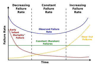
Deterioration modeling is the process of modeling and predicting the physical conditions of equipment, structures, infrastructure or any other physical assets. The condition of infrastructure is represented either using a deterministic index or the probability of failure. Examples of such performance measures are pavement condition index for roads or bridge condition index for bridges. For probabilistic measures, which are the focus of reliability theory, probability of failure or reliability index are used. Deterioration models are instrumental to infrastructure asset management and are the basis for maintenance and rehabilitation decision-making. The condition of all physical infrastructure degrade over time. A deterioration model can help decision-makers to understand how fast the condition drops or violates a certain threshold.

Pavement crack refers to a variety of types of pavement distresses that occur on the surface of pavements. Different types of pavements develop different cracks. Type of cracking is also correlated with the type of climate and traffic. Sometimes the cracks are aggregated using an index such as Crack index, and sometimes they are merged with other distresses and are reported using Pavement Condition Index.
The rolling straight-edge is an instrument used to measure the surface regularity of roads and similar structures such as airport runways. It consists of a straightedge of a fixed distance mounted on wheels with a sensor at the centrepoint measuring deviation in height. It is rolled along the road surface and set to specific trigger levels which can be logged automatically or by means of an audible alarm. The rolling straight-edge was developed by the British Road Research Laboratory to replace earlier manual methods of measurement using rulers. It has been used by several countries and remains in use in the United Kingdom, Germany and Taiwan.

Granular base equivalency or granular base equivalence (GBE) is a measure of total pavement thickness. Since pavement is composed of multiple layers with different physical properties, its total thickness is measured by GBE. GBE translates the thickness of different road layers to a number using a set of coefficients. So, to calculate the GBE, the depth of each layer should be multiplied by the granular equivalency factor for the material in that layer. In the next step the sum of the converted layer thicknesses is calculated. This sum is called granular base equivalency, which is a popular and important measure in pavement design and pavement performance modeling.
The present serviceability index (PSI) is a pavement performance measure. Introduced by the American Association of State Highway and Transportation Officials (AASHTO), the PSI is one of the most widely used pavement performance indicators after pavement condition index (PCI) and international roughness index (IRI). This performance indicator ranges between 0 and 5, 0 representing a failed pavement and 5 an excellent one. Since the PSI entails slope variance, it is correlated with performance indicators related to roughness such as IRI.