The Peace River Wildland Provincial Park preserves the forest and grassland habitats within the Peace River valleys since these areas are important wildlife corridors for deer, elk, wolf, bears and is also home to a wide variety of birds.[1]
National Historic Site, Fort Fork Site is also located in the park on the east bank of the Peace River.[2] The fort was built in 1792 by the North West Company. Explorers Alexander Mackenzie and David Thompson spent the winters at Fort Fork in 1792 and 1802 respectively. The fort was abandoned in 1805 and has since been almost completed eroded by the Peace River.[3] A flag planted at Fort Fork's former site is all that remains. Mackenzie Cairn was erected on River Lot 19 along Shaftesbury Trail in the Municipal District of Peace No. 135 in 1929 to commemorate Fort Fork.
Activities
The confluence of the Peace and Smoky is dotted with small islands, some of which create slow moving waters and good fishing opportunities. Fish species include: Arctic Grayling, Brook Stickleback, Bull Trout, Burbot, Emerald Shiner, Flathead Chub, Goldeye, Kokanee, Lake Chub, Lake Trout, Lake Whitefish, Longnose Dace, Longnose Sucker, Mountain Whitefish, Ninespine Stickleback, Northern Pike, Northern Pikeminnow, Pearl Dace, Prickly Sculpin, Rainbow Trout, Redside Shiner, Slimy Sculpin, Spoonhead Sculpin, Spottail Shiner, Trout-Perch, Walleye, White Sucker and Yellow Perch.
Road access is limited although the Peace River Wildland Provincial Park features a number of trails for hiking, off-highway vehicle riding and snowmobiling. There are also viewing points located strategically in the park.
Tangent Park
Tangent Park is a park operated by Birch Hills County located 24 kilometres southwest of the Town of Peace River, and 33 kilometres northwest of Tangent on Highway 740 within the Peace River Wildland Provincial Park. It is adjacent to the Peace River and offers full hook ups, kitchen shelter, group picnic area, group camping area, tenting area, horse watering stations, concession, showers, hiking trails, horseshoes, a playground, and fishing.
Shaftesbury Ferry
The Shaftesbury Ferry operates on the Shaftesbury Trail (Highway 740) crossing over the 325-metre-long Peace River crossing from the M.D. of Peace to the Birch Hills County. With a 38 T capacity, the 22.56-metre-long by 12.12-metre-wide by 1.22-meter-hull-depth ferry was built in 1962 and has a rated capacity of 2 crew, 46 passengers and 8 mid-size cars.[4] Access to Tangent Park from the Town of Peace River involves a ride on this ferry. It is operated by Grimshaw based LaPrairie Works.
In winter, an ice road is built across the Peace River at this crossing location.
Gallery
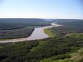
The Smoky River from a view point in the Peace River Wildland Provincial Park
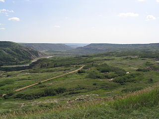
Wildlife in Peace River Wildland Provincial Park as viewed from Sagitawa Lookout
The Ogoki River is a river in the Thunder Bay and Cochrane Districts of Ontario. It springs from the wilderness just east of Savant Lake, flowing north of Lake Nipigon to Ogoki, where it joins the Albany River which empties into James Bay. The river is 480 kilometres (300 mi) long.
The Red Deer River is a river in Alberta and a small portion of Saskatchewan, Canada. It is a major tributary of the South Saskatchewan River and is part of the larger Saskatchewan / Nelson system that empties into Hudson Bay.
Cold Lake Provincial Park is a provincial park in northeastern Alberta, Canada.
Dry Island Buffalo Jump Provincial Park is a provincial park in Central Alberta, Canada, located about 103 km (64 mi) southeast of Red Deer and 16 km (9.9 mi) northeast of Trochu, 1 mile north and 10 miles east of Huxley. The park is situated along the Red Deer River and features badlands topography. Its name derives from the large plateau in the middle of the park, 200 m (660 ft) above the Red Deer River, which has never been developed by humans and retains virgin prairie grasses.
Sheep River Provincial Park is a provincial park located in Alberta, Canada, 23 kilometres (14 mi) west of Diamond Valley on highway 546. It is part of the Kananaskis Country park system and encompasses a portion of the Sheep River valley.
O'Brien Provincial Park is a provincial park in Alberta, Canada, located 15 km (9.3 mi) south from Grande Prairie, on Highway 666.
Badger Creek is a stream in Houston County, in the U.S. state of Minnesota. It is a tributary of the South Fork Root River, which it meets east of Houston, Minnesota. Badger Creek was named for the badgers once common in the area.
The Raven River or South Raven River is a major tributary of the Red Deer River located in Central-Western Alberta, Canada. The river is located in both the Clearwater County and Red Deer County.
The North Raven River or Stauffer Creek is a major tributary of the Raven River located in western Central Alberta, Canada. It is located in the Red Deer River system. The river is a popular place for anglers.
This page is based on this Wikipedia article Text is available under the CC BY-SA 4.0 license; additional terms may apply. Images, videos and audio are available under their respective licenses.