
The Peak District is an upland area in central-northern England, at the southern end of the Pennines. Mostly in Derbyshire, it extends into Cheshire, Greater Manchester, Staffordshire, West Yorkshire and South Yorkshire. It is subdivided into the Dark Peak, moorland dominated by gritstone, and the White Peak, a limestone area with valleys and gorges. The Dark Peak forms an arc on the north, east and west of the district, and the White Peak covers central and southern areas. The highest point is Kinder Scout. Most of the area is within the Peak District National Park, a protected landscape designated in 1951.

Derbyshire is a ceremonial county in the East Midlands of England. It borders Greater Manchester, West Yorkshire, and South Yorkshire to the north, Nottinghamshire to the east, Leicestershire to the south-east, Staffordshire to the south and west, and Cheshire to the west. Derby is the largest settlement, and Matlock is the county town.

Matlock is the county town of Derbyshire, England. It is in the south-eastern part of the Peak District, with the National Park directly to the west. The spa resort of Matlock Bath is immediately south of the town as well as Cromford lying further south still. The civil parish of Matlock Town had a population in the 2021 UK census of 10,000.

Matlock Bath is a village and civil parish in Derbyshire, England. It lies in the Derbyshire Dales, south of Matlock on the main A6 road, and approximately halfway between Buxton and Derby. The population of the civil parish at the 2011 census was 753. Originally built at the head of a dead-end dirt road running along the valley of the River Derwent from Matlock, the settlement developed in the 19th century as residential and a spa town which remains a tourist destination. The steep hillside restricts development, with most buildings on one side of the valley and only footbridges across the river. The road was upgraded, becoming a through-way, now designated A6, avoiding the previous coaching road approach to Matlock from Cromford over very steep hills near to the Riber plateau area.

Derbyshire Dales is a local government district in Derbyshire, England. The district was created in 1974 as West Derbyshire; the name was changed to Derbyshire Dales in 1987. The council is based in the town of Matlock, and the district also includes the towns of Ashbourne, Bakewell, Darley Dale and Wirksworth, as well as numerous villages and extensive rural areas. Much of the district is within the Peak District National Park.

Wirksworth is a market, and former quarry town in the Derbyshire Dales district of Derbyshire, England. Its population of 4,904 in the 2021 census was estimated at 5,220 in 2023. Wirksworth contains the source of the River Ecclesbourne. The town was granted a market charter by Edward I in 1306 and still holds a market on Tuesdays in the Memorial Gardens. The parish church of St Mary's is thought to date from 653. The town developed as a centre for lead mining and stone quarrying. Many lead mines were owned by the Gell family of nearby Hopton Hall.

Cromford is a village and civil parish in Derbyshire, England, in the valley of the River Derwent between Wirksworth and Matlock. It is 17 miles (27 km) north of Derby, 2 miles (3.2 km) south of Matlock and 1 mile (1.6 km) south of Matlock Bath. It is first mentioned in the 11th-century Domesday Book as Crumforde, a berewick of Wirksworth, and this remained the case throughout the Middle Ages. The population at the 2011 Census was 1,433. It is principally known for its historical connection with Richard Arkwright and the nearby Cromford Mill, which he built outside the village in 1771. Cromford is in the Derwent Valley Mills World Heritage Site.
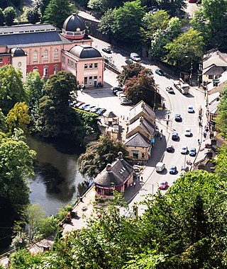
The Heights of Abraham is a tourist attraction in Matlock Bath, Derbyshire, England. It consists of a hilltop park on top of Masson Hill, accessed from the village by the Heights of Abraham cable car. The heights are named after a supposed resemblance to the Plains of Abraham, also known as the Heights of Abraham, in Quebec, Canada, where General James Wolfe died in battle against the French in 1759.

This article details some of the history of lead mining in Derbyshire, England.

The history of Derbyshire can be traced back to human settlement since the last Ice Age, over 10,000 years ago. The county of Derbyshire in England dates back to the 11th century.

Bonsall is a village and civil parish in the Derbyshire Dales on the edge of the Peak District. The civil parish population, including Brightgate and Horse Dale, was 775 at the 2001 Census, increasing to 803 at the 2011 Census.

Matlock Bath railway station is a Grade II listed railway station owned by Network Rail and managed by East Midlands Railway. It is located in the village of Matlock Bath in Derbyshire, England. The station is unmanned by rail staff and is located on the Derwent Valley Line, 16.25 miles (26.15 km) north of Derby towards Matlock.

Odin Mine is a disused lead mine in the Peak District National Park, situated at grid reference SK133835. It lies on a site of 25 hectares near the village of Castleton, England. It is the oldest documented mine in Derbyshire and is thought to be one of the oldest lead mines in England. The mine is a Scheduled Ancient Monument and has biological and geological significance within the Castleton Site of Special Scientific Interest.

Great Masson Cavern is one of two caves at the Heights of Abraham, Matlock Bath, Derbyshire, England. The other is Great Rutland Cavern.

The Grand Pavilion, Matlock Bath, is an Edwardian building in Matlock Bath, Derbyshire, England, built in 1910 and run by the local community and operated by their own charitable company. It houses the Peak District Lead Mining Museum.
The Beans and Bacon mine is a disused lead mine on Bonsall Moor near the village of Bonsall, Derbyshire, United Kingdom. The nearest large town is Matlock. The mine was in operation from 1920 to 1925, but workings around the mine date back to at least 1740 and some are thought to be medieval, making it of some archaeological importance. No reason has been given for the mine's unusual name, but other mines in the area include Mule Spinner, Frogs Hole, Cackle Mackle and Wanton Legs, making the name typical for the area.
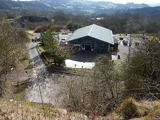
The National Stone Centre is a museum, an industrial heritage discovery centre and a Site of Special Scientific Interest at Wirksworth, near Matlock Bath in Derbyshire.

The Derbyshire Dome is a geological formation across mid-Derbyshire in England.

Bradwell Moor is a moorland hill above the village of Bradwell, Derbyshire in the Peak District. The summit is 471 metres (1,545 ft) above sea level.

