Related Research Articles
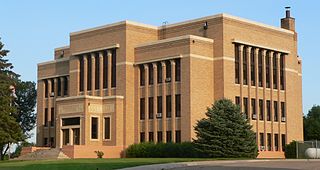
Charles Mix County is a county in the U.S. state of South Dakota. As of the 2020 United States Census, the population was 9,373. Its county seat is Lake Andes. The county was created in 1862 and organized in 1879. It was named for Charles Eli Mix, an official of the Bureau of Indian Affairs influential in signing a peace treaty with the local Lakota Indian tribes. The easternmost approximately 60% of the county comprises the Yankton Indian Reservation.

Wounded Knee Creek is a tributary of the White River, approximately 100 miles (160 km) long, in Oglala Lakota County, South Dakota in the United States. Its Lakota name is Čhaŋkpé Ópi Wakpála.
There are over a dozen lakes named Mud Lake within the U.S. state of South Dakota. According to the Federal Writers' Project, these lakes were so named on account of the muddy condition of the lake bed or lake shore.

Lake Francis Case is a large reservoir impounded by Fort Randall Dam on the Missouri River in south-central South Dakota, United States. The lake has an area of 102,000 acres (410 km2) and a maximum depth of 140 ft (43 m). Lake Francis Case has a length of approximately 107 mi (172 km) and has a shoreline of 540 mi (870 km). The lake is the eleventh-largest reservoir in the United States and is located within the counties of: Charles Mix, Gregory, Lyman, Brule, and Buffalo. The lake stretches from Pickstown, South Dakota upstream to Big Bend Dam.
Sioux National Forest was a National Forest (NF) established by Executive Order 908 on July 1, 1908. The order called for the consolidation of the following national forests and forest units into a single entity:

Leading Creek is a tributary of the Ohio River, 29.5 miles (47.5 km) long, in southeastern Ohio in the United States. Via the Ohio River, it is part of the watershed of the Mississippi River, draining an area of 150 square miles (390 km2) on the unglaciated portion of the Allegheny Plateau. The creek's headwaters are in southern Athens County and it flows for most of its length in western Meigs County; its tributaries also drain a small area of northeastern Gallia County.
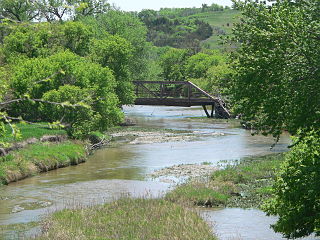
Ponca Creek is a stream that flows from southern South Dakota and into northern Nebraska. It is 139 miles (224 km) long. Its source is about 4 miles (6.4 km) west of U.S. 183, near Colome. It flows into the Missouri River 6 miles (9.7 km) northwest of Niobrara. Ponca Creek starts out going east, then takes a southeast direction. It flows like that until around Bristow, Nebraska where it turns east again until it flows into the Missouri River. The entire Ponca Creek watershed drains 520,000 acres (2,100 km2). The watershed stretches from central Tripp County to central Gregory County.

The Carrizo Badlands are a landform of badlands that lie within Anza-Borrego Desert State Park in eastern San Diego County, and in the Carrizo Impact Area in western Imperial County, in Southern California.
Potato Creek is an unincorporated community in Jackson County, in the U.S. state of South Dakota.
Campbell Creek is a stream in the U.S. state of South Dakota.
Castalia Creek is a stream in the U.S. state of South Dakota.
Choteau Creek is a stream in the U.S. state of South Dakota.
Edgerton Creek is a stream in the U.S. state of South Dakota.
Foster Creek is a stream in the U.S. state of South Dakota.
Jim Creek is a stream in the U.S. state of South Dakota. Jim Creek derives its name from the James River, of which it is a tributary.
Randall Creek is a stream in the U.S. states of Nebraska and South Dakota.
Redstone Creek is a stream in Clark, Kingsbury, Miner and Sanborn counties in the U.S. state of South Dakota.
Snake Creek is a stream in the U.S. state of South Dakota. It is a tributary of James River.
North Scalp Creek is a stream system in the U.S. state of South Dakota.
South Scalp Creek is a stream system in the U.S. state of South Dakota.
References
- ↑ U.S. Geological Survey Geographic Names Information System: Pease Creek
- ↑ Federal Writers' Project (1940). South Dakota place-names, v.1-3. University of South Dakota. p. 48.
43°08′15″N98°44′35″W / 43.13750°N 98.74306°W