Pelican Point was formerly named Point Currie after Captain Currie, who in 1829 received an allotment of land in the area and which became known as Crawley.
The area south of the point's axis is now a bird sanctuary.[1]
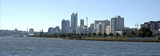
The northern side includes the Royal Perth Yacht Club, Mounts Bay Sailing Club,[2] the 1st Pelican Point Sea Scouts[3][4] and a public boat ramp. A road named Australia II Drive runs off Hackett Drive.
↑ "NEW CLUB ROOMS". Sunday Times (Perth). No.2177. Western Australia. 15 October 1939. p.16. Retrieved 30 August 2018– via National Library of Australia.
The Swan River is a major river in the southwest of Western Australia. The river runs through the metropolitan area of Perth, Western Australia's capital and largest city.
Broome, also known as Rubibi by the Yawuru people, is a coastal pearling and tourist town in the Kimberley region of Western Australia, 2,046 km (1,271 mi) north of Perth. The town recorded a population of 14,660 in the 2021 census. It is the largest town in the Kimberley region.
Rottnest Island, often colloquially referred to as "Rotto", is a 19-square-kilometre (7.3 sq mi) island off the coast of Western Australia, located 18 kilometres (11 mi) west of Fremantle. A sandy, low-lying island formed on a base of aeolianite limestone, Rottnest is an A-class reserve, the highest level of protection afforded to public land.
Western Port, commonly but unofficially known as Western Port Bay, is a large tidal bay in southern Victoria, Australia, opening into Bass Strait. It is the second largest bay in the state. Geographically, it is dominated by two large islands; French Island and Phillip Island. At the time it was renamed, its position was west of other known ports and bays, but Western Port has become something of a misnomer as it lies just to the east of the larger Port Phillip and the city of Melbourne. It is visited by Australian fur seals, whales and dolphins, as well as many migratory waders and seabirds. It is listed under the Ramsar Convention as a wetland of international significance.
Roebuck Bay is a bay on the coast of the Kimberley region of Western Australia. Its entrance is bounded in the north by the town of Broome, and in the south by Bush Point and Sandy Point. It is named after HMS Roebuck, the ship captained by William Dampier when he explored the coast of north-western Australia in 1699. The Broome Bird Observatory lies on the northern coast of the bay.
Perth Water is a section of the Swan River on the southern edge of the central business district of Perth, Western Australia. It is between the Causeway to the east, and Narrows Bridge to the west – a large wide but shallow section of river, and the northern edge of the suburb South Perth. It is considered a landmark of the City of Perth.
Crawley is an affluent western suburb of Perth, the capital city of Western Australia. The area is part of the local government area of the City of Perth and was previously shared between the City of Subiaco and City of Perth. It is about 5.8 kilometres (4 mi) from the Perth CBD via Mounts Bay Road.
The Canning River is a major tributary of the Swan River in the South West Land Division of Western Australia. It is home to much wildlife including dolphins, pelicans, swans and many other bird species.
St Alouarn Islands are a group of islands and rocks south-east of Cape Leeuwin in Western Australia, approximately 11 km south of Augusta in Flinders Bay.
Matilda Bay or Crawley Bay is a natural bay in the Swan River in Western Australia, adjacent to the Perth suburb of Crawley. It extends from Pelican Point to Mounts Bay Road below Kings Park.
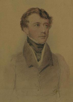
Captain Mark John Currie RN played a significant role in the exploration of Australia and the foundation of the Swan River Colony, later named Western Australia.
Scouting in Western Australia is predominantly represented by a branch of Scouts Australia and Girl Guides Western Australia, a member organisation of Girl Guides Australia.
Point Belches is a small point on the south side of Swan River, Western Australia, about 250 metres (820 ft) east of The Narrows within the area known as Perth Water. The land is part of the South Perth Esplanade, and the water off the point is used as a commercial water skiing area.
The Royal Perth Yacht Club (RPYC) is a yacht club in Perth, Western Australia. It is the third oldest yacht club in Australia after the Royal Yacht Club of Victoria and the Royal Sydney Yacht Squadron. It is based at the Crawley Marina on Pelican Point and at the Fremantle Annexe in Challenger Harbour.
Melville Water is a significant section of the Swan River in Perth, Western Australia. It is located west and downstream of Perth Water, from which it is separated by the Narrows Bridge.
Pelican Point is a northeastern suburb of Bunbury, Western Australia, that is six kilometres from the centre of Bunbury and adjoins the suburb of Eaton. It is within the City of Bunbury local government area.
Mounts Bay Road is a major road in Perth, Western Australia, extending southwest from the central business district along the north bank of the Swan River, at the base of Kings Park.
The Double Sunrise service was formed in July 1943 to re-establish the Australia–England air link that had been cut due to the fall of Singapore in February 1942. The service initially operated from its base in Nedlands, Western Australia near Perth, to the Royal Air Force base at Lake Koggala near Galle in Ceylon. It was later extended to Karachi in British India, which was the terminus for the BOAC service from England. The name of the service was derived from the crew and passengers observing two sunrises on the westbound flight from Australia.
Evans Bay is a large bay at the southern end of Wellington Harbour, New Zealand. Located between the Miramar Peninsula and Hataitai, it was the site of New Zealand's first patent slip and served as Wellington's international flying-boat terminal from 1938 until 1956. It is named after George Samuel Evans, an early Wellington settler.
This page is based on this Wikipedia article Text is available under the CC BY-SA 4.0 license; additional terms may apply. Images, videos and audio are available under their respective licenses.