Harpalyke, also known as Jupiter XXII, is a retrograde irregular satellite of Jupiter. It was discovered by a team of astronomers from the University of Hawaii led by Scott S. Sheppard in 2000, and given the temporary designation S/2000 J 5. In August 2003, the moon was named after Harpalyke, the incestuous daughter of Clymenus, who in some accounts was also a lover of Zeus (Jupiter).

Toketee Falls is a waterfall in Douglas County, Oregon, United States, on the North Umpqua River at its confluence with the Clearwater River. It is located approximately 58 miles (93 km) east of Roseburg near Oregon Route 138.

Two nuclides are isotones if they have the same neutron number N, but different proton number Z. For example, boron-12 and carbon-13 nuclei both contain 7 neutrons, and so are isotones. Similarly, 36S, 37Cl, 38Ar, 39K, and 40Ca nuclei are all isotones of 20 because they all contain 20 neutrons. Despite its similarity to the Greek for "same stretching", the term was formed by the German physicist K. Guggenheimer by changing the "p" in "isotope" from "p" for "proton" to "n" for "neutron".
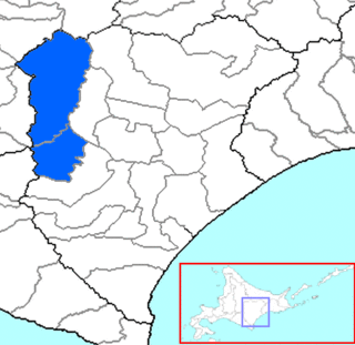
Kamikawa is a district located in Tokachi Subprefecture, Hokkaido, Japan.
A prime number p is called a Chen prime if p + 2 is either a prime or a product of two primes. The even number 2p + 2 therefore satisfies Chen's theorem.

Saltwater River is a former penal colony on the Tasman Peninsula in Tasmania, Australia. It is 23 kilometres (14 mi) from Port Arthur, and 106 kilometres (66 mi) from Hobart. At the 2006 census, Saltwater River had a population of 156.
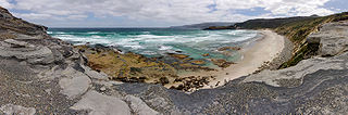
The South Coast Track is a bushwalking track located in the South Coast region of Tasmania, Australia. The 85-kilometre (53 mi) track traverses remote wilderness within the Southwest National Park, part of the Tasmanian Wilderness World Heritage Site, and is managed as a wilderness walk. The Tasmanian Parks & Wildlife Service recommend that experienced bushwalkers can take six-to-eight days to cover the track in one direction.

The Williams River is a 27.0-mile (43.5 km) river in the U.S. state of Vermont. It is a tributary of the Connecticut River. Its watershed covers 117 square miles; land use is about 80% forested and 4% agricultural, and the upper river supports wild brook trout and brown trout.
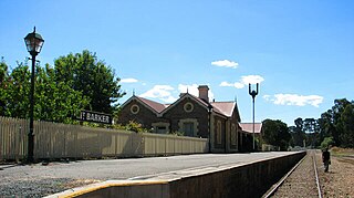
Mount Barker railway station is a preserved railway station in South Australia on the Victor Harbor line, formerly operated by South Australian Railways and its successor, Australian National. With only broad gauge track running through the station, it has been disconnected from the Adelaide metropolitan network since the standardisation of the Adelaide-Wolseley line in 1995. It is still used by SteamRanger, a heritage train operator between Mount Barker and Victor Harbor.
Green Island is a small island nature reserve with an area of 4.17 ha close to the south-eastern coast of Tasmania, Australia at the entrance to the River Derwent.
Arch Rock is a sandstone islet, with an area of 0.44 ha and containing a natural arch, in south-eastern Australia. It is part of the Partridge Island Group, lying close to the south-eastern coast of Tasmania, in the D'Entrecasteaux Channel between Bruny Island and the mainland.
Charity Island is an islet with an area of 0.6 ha in south-eastern Australia. It is part of the Partridge Island Group, lying close to the south-eastern coast of Tasmania, in the D'Entrecasteaux Channel between Bruny Island and the mainland. Its neighbouring islets are named "Faith" and "Hope".
The Hope Island, part of the Partridge Island Group, is a small island that lies close to the south-eastern coast of Tasmania, Australia. The island is located in the D'Entrecasteaux Channel between Bruny Island and the Tasmanian mainland. Its neighbouring islets are named Faith and Charity, and also the Arch Rock.
The Faith Island, part of Partridge Island Group, is a low, flat islet in south-eastern Tasmania, Australia. The islet lies in the D'Entrecasteaux Channel between Bruny Island and the Tasmania mainland. It contains two gravestones, concealed in the scrub in the north-east of the island. Its neighbouring islets are named Charity and Hope and also the Arch Rock.

The Egg Islands are a small group of low-lying estuarine islands in the tidal lower reaches of the Huon River of south-east Tasmania, Australia. They face the town of Franklin which lies on the western bank of the river.
King's Highway 43, also known as Highway 43, was a provincially maintained highway in the Canadian province of Ontario. On January 1, 1998, the entire route was transferred to the county that each section resided in, resulting in the current designations of Lanark County Road 43, Leeds and Grenville Road 43 and Stormont, Dundas and Glengarry Road 43. Highway 43 ran somewhat parallel to and between Highway 401 and Highway 417 from Highway 7 in Perth to Highway 34 in Alexandria, passing through several small towns along the way. At 154.2 km (95.8 mi),
it is the longest highway in Ontario to be decommissioned entirely during the mass transfer of Highways in 1997 and 1998.
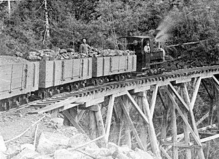
The Sandfly Colliery Tramway was a 20 km (12 mi), 2 ft narrow gauge tramway linking the Kaoota Mine to Margate, Tasmania. Constructed in 1905–06, the Tramway climbed 457 m (1,499 ft) above sea level and crossed ten bridges. After coal mining ceased the tramway was used to transport logs, fruit and passengers. The line was lifted and abandoned in 1922 after bushfires destroyed several bridges along the line. Currently, 6 km (3.7 mi) of the old track is used as cycling/walking tracks, while the remainder of the old line is on private property.

Pelverata is a town in Tasmania, Australia, to the east of Huonville.


