Related Research Articles
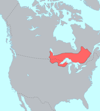
The Ojibwe, Ojibwa, Chippewa, or Saulteaux are an Anishinaabe people in what is currently southern Canada, the northern Midwestern United States, and Northern Plains. They are Indigenous peoples of the Subarctic and Northeastern Woodlands.
The Chippewa Cree Tribe is a federally recognized tribe on the Rocky Boy Reservation in Montana who are descendants of Cree who migrated south from Canada and Chippewa (Ojibwe) who moved west from the Turtle Mountains in North Dakota in the late nineteenth century. The two different peoples spoke related but distinct Algonquian languages.

The Red Lake Indian Reservation covers 1,260.3 sq mi in parts of nine counties in Minnesota, United States.

Rocky Boy's Indian Reservation is one of seven Native American reservations in the U.S. state of Montana. Established by an act of Congress on September 7, 1916, it was named after Ahsiniiwin, the chief of the Chippewa band, who had died a few months earlier. It was established for landless Chippewa (Ojibwe) Indians in the American West, but within a short period of time many Cree (Nēhiyaw) and Métis were also settled there. Today the Cree outnumber the Chippewa on the reservation. The Bureau of Indian Affairs (BIA) recognizes it as the Chippewa Cree Reservation.
The White Earth Band of the Minnesota Chippewa Tribe, also called the White Earth Nation, is a federally recognized Native American band located in northwestern Minnesota. The band's land base is the White Earth Indian Reservation.

The Mille Lacs Band of Ojibwe, also known as the Mille Lacs Band of Chippewa Indians, is a federally recognized American Indian tribe in east-central Minnesota. The Band has 4,302 members as of 2012. Its homeland is the Mille Lacs Indian Reservation, consisting of District I, District II, District IIa, and District III.
The Turtle Mountain Band of Chippewa Indians is a federally recognized Native American tribe of Ojibwe based on the Turtle Mountain Indian Reservation in Belcourt, North Dakota. The tribe has 30,000 enrolled members. A population of 5,815 reside on the main reservation and another 2,516 reside on off-reservation trust land.
The Mille Lacs Indians, also known as the Mille Lacs and Snake River Band of Chippewa, are a Band of Indians formed from the unification of the Mille Lacs Band of Mississippi Chippewa (Ojibwe) with the Mille Lacs Band of Mdewakanton Sioux (Dakota). Today, their successor apparent Mille Lacs Band of Ojibwe consider themselves as being Ojibwe, but many on their main reservation have the ma'iingan (wolf) as their chief doodem (clan), which is an indicator of Dakota origins.

The Grand Traverse Band of Ottawa and Chippewa Indians is a federally recognized Native American tribe located in northwest Michigan on the Leelanau Peninsula. Sam McClellan is the current tribal chairman, elected in June 2016 to a four-year term after succeeding Al Pedwaydon, who served from 2012 to 2016.
Mississippi River Band of Chippewa Indians or simply the Mississippi Chippewa, are a historical Ojibwa Band inhabiting the headwaters of the Mississippi River and its tributaries in present-day Minnesota.
The Little Shell Band of Chippewa are a historic sub-band of the Pembina Band of Chippewa Indians led by Chief Little Shell in the nineteenth century. Based in North Dakota around the Pembina River, they are part of the Ojibwe, one of the Anishinaabe peoples, who occupied territory west of the Great Lakes by that time. Many had partial European ancestry from intermarriage by French-Canadian fur traders and trappers. Some began to identify as Métis, today recognized as one of the Indigenous Peoples of Canada. Located in the 17th century in the areas around the Great Lakes, they gradually moved west into North Dakota and Montana.
Pillager Band of Chippewa Indians are a historical band of Chippewa (Ojibwe) who settled at the headwaters of the Mississippi River in present-day Minnesota. Their name "Pillagers" is a translation of Makandwewininiwag, which literally means "Pillaging Men". The French called them Pilleurs, also a translation of their name. The French and Americans adopted their autonym for their military activities as the advance guard of the Ojibwe in the invasion of the Dakota country.

Turtle Mountain, or the Turtle Mountains, is an area in central North America, in the north-central portion of the U.S. state of North Dakota and southwestern portion of the Canadian province of Manitoba, approximately 62 miles (100 km) south of the city of Brandon on Manitoba Highway 10 / U.S. Route 281. It is a plateau 2,000 ft above sea level, 300 ft to 400 ft above the surrounding countryside, extending 20 mi (32 km) from north to south and 40 mi (64 km) from east to west. Rising 1,031 feet (314 m), North Dakota's most prominent peak, Boundary Butte, is located at the western edge of the plateau.

Porter James McCumber was a United States senator from North Dakota. He was a supporter of the 1906 "Pure Food and Drug Act", and of the League of Nations.
The Lake Superior Chippewa are a large number of Ojibwe (Anishinaabe) bands living around Lake Superior; this territory is considered part of northern Michigan, Wisconsin, and Minnesota in the United States. They migrated into the area by the seventeenth century, encroaching on the Eastern Dakota people who had historically occupied the area. The Ojibwe defeated the Eastern Dakota, who migrated west into the Great Plains after the final battle in 1745. While they share a common culture including the Anishinaabe language, this highly decentralized group of Ojibwe includes at least twelve independent bands in the region.
Turtle Mountain Indian Reservation is a reservation located in northern North Dakota, United States. It is the land base for the Turtle Mountain Band of Chippewa Indians. The population of the Turtle Mountain Indian Reservation consists of Plains Ojibwe and Métis peoples; the reservation was established in 1882.
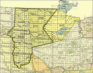
By the Treaty of Old Crossing (1863) and the Treaty of Old Crossing (1864), the Pembina and Red Lake bands of the Ojibwe, then known as Chippewa Indians, purportedly ceded to the United States all of their rights to the Red River Valley. On the Minnesota side, the ceded territory included all lands lying west of a line running generally southwest from the Lake of the Woods to Thief Lake, about 30 miles (48 km) west of Red Lake, and then angling southeast to the headwaters of the Wild Rice River near the low-lying divide separating the watershed of the Red River of the North from the watershed of the Mississippi River. On the North Dakota side, the ceded territory included all of the Red River Valley north of the Sheyenne River. The total land area, roughly 127 miles (204 km) wide east to west and 188 miles (303 km) long north to south, consisted of nearly 11,000,000 acres (45,000 km2) of rich prairie land and forests.
Little Shell Tribe of Chippewa Indians of Montana is a federally recognized tribe of Ojibwe, Métis, and Cree people in Montana. The name of the tribe is often shortened to Little Shell. The current population of enrolled tribal members is approximately 6,500. They have a 35,000-sq. foot office complex in Great Falls.

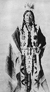
Thomas Little Shell III was a chief of a band of the Ojibwa (Chippewa) tribe in the second half of the nineteenth century, when the Anishinaabeg had a vast territory ranging from southwestern Canada into the northern tier of the United States, from the Dakotas and into Montana.
Asiniiwin, translated Rocky Boy or Stone Child, was an important Chippewa leader who was chief of a band in Montana in the late 19th century and early 20th century. His advocacy for his people helped gain the establishment of what is called Rocky Boy's Indian Reservation in his honor. Formed from part of Fort Assiniboine, which was closed, it is located in Hill and Chouteau counties in north central Montana.