Related Research Articles

Fairwater is a community and suburb of Cwmbran in the county borough of Torfaen, in south east Wales, and was built by the Cwmbran Development Corporation between 1963 and 1966.
Dixton is a small village located 1 mile (1.6 km) north east of Monmouth, on the banks of the River Wye, in Monmouthshire, south east Wales. The parish originally comprised the two manors of Dixton Newton and Dixton Hadnock, on either side of the river.

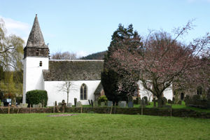
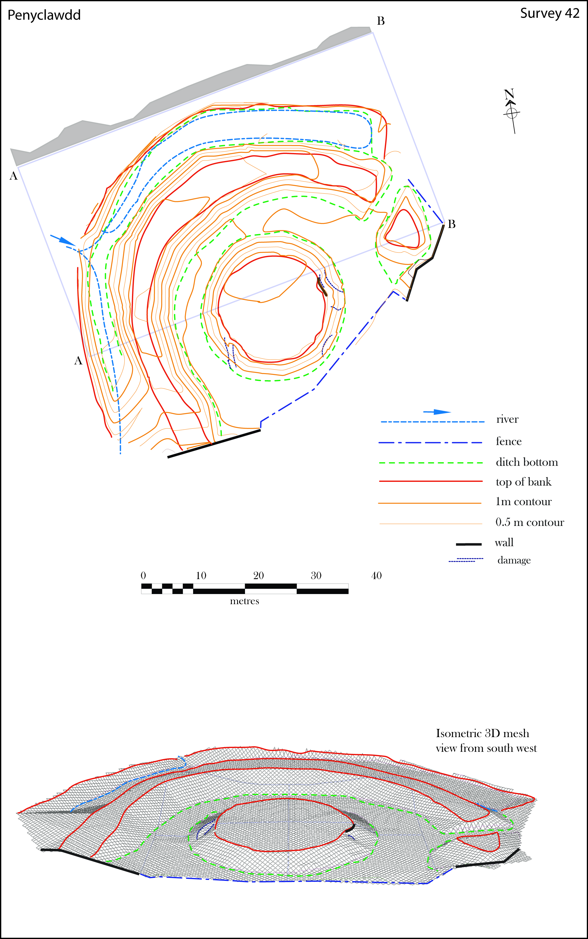
Pen-y-clawdd is a village in Monmouthshire, south east Wales, situated between Raglan and Monmouth. The village is the site of a medieval fortification and there is a historic church with an ancient cross in the churchyard which is a scheduled monument.

The site of Castell Arnallt, sometimes known as Castle Arnold, is located near the village of Llanover in the Usk valley of Monmouthshire, Wales, some 4 miles (6.4 km) south east of Abergavenny. It was the fortified court house, or llys, of Seisyll ap Dyfnwal, lord of Over Gwent or Gwent Uwchcoed, before it was destroyed after Seisyll and some of his household were killed at Abergavenny Castle by William de Braose in 1175. The land is now in agricultural use, with no remains visible.

Pen-y-Clawdd Court is a Grade I listed country house in Llanvihangel Crucorney, Monmouthshire, Wales, situated 1 mile (1.6 km) to the southwest of the village off the A465 road. It is a Tudor manor house, which lies within the bailey of what was Pen y Clawdd Castle, and is thought to date from circa 1625.

Monmouthshire is a county and principal area of Wales. It borders Torfaen and Newport to the west; Herefordshire and Gloucestershire to the east; and Powys to the north. The largest town is Abergavenny, with the other major towns being Chepstow, Monmouth, and Usk. The county is 850 km2 in extent, with a population of 95,200 as of 2020. The present county was formed under the Local Government (Wales) Act 1994, which came into effect in 1996, and comprises some sixty percent of the historic county. Between 1974 and 1996, the county was known by the ancient title of Gwent, recalling the medieval Welsh kingdom. In his essay on local government in the fifth and final volume of the Gwent County History, Robert McCloy suggests that the governance of "no county in the United Kingdom in the twentieth century was so transformed as that of Monmouthshire".

Old Trecastle Farmhouse, Pen-y-clawdd, Monmouthshire is a farmhouse, originally, a gentry house, dating from the 16th and 17th centuries. It stands on the site of the outworks of a Norman motte-and-bailey castle. The house is Grade II* listed.
Pen-y-clawdd Farmhouse, Raglan, Monmouthshire is a gentry house dating from the early 17th century. Owned by the Bradburys, High Sheriffs of Monmouthshire, and later by the Williams family and then the Prichards of Penallt, it remains a privately owned farmhouse. The building is Grade II* listed.
References
- 1 2 3 Wiles, J. (16 September 2002). "Pen-y-Clawdd Court, Castle Mound". National Monuments Record of Wales (NMRW). Royal Commission on the Ancient and Historical Monuments of Wales (RCAHMW). NPRN 306454. Retrieved 7 April 2016.
- 1 2 Thomas, Jeffrey L. (2009). "Pen y Clawdd Castle". Castles of Wales. Retrieved 7 April 2016.
- ↑ "Pen y Clawdd Castle Mound". National Monuments Record of Wales (NMRW) . Cadw. 12 December 1950. Cadw Id: MM145.
{{cite web}}: Missing or empty|url=(help) - 1 2 "Pen-y-Clawdd Court". Statutory List of Buildings . Cadw. 29 January 1998 [Listed 1952]. Cadw Building ID: 1926. Retrieved 7 April 2016– via Historic Wales.
- 1 2 "Stable and cowhouse ranges at Pen-y-Clawdd Court". Statutory List of Buildings . Cadw. 29 January 1998 [Listed 1989]. Cadw Building ID: 19252. Retrieved 7 April 2016– via Historic Wales.
- 1 2 "Barn to south of Pen-y-Clawdd Court". Statutory List of Buildings . Cadw. 29 January 1998 [Listed 1989]. Cadw Building ID: 2824. Retrieved 7 April 2016– via Historic Wales.
- ↑ "Pen-y-Clawdd Castle Mound". Historic Environment Record (HER) . Glamorgan-Gwent Archaeological Trust (GGAT). PRN 01622g. Retrieved 8 April 2016– via archwilio (online database of the four Welsh Archaeological Trusts).
{{cite web}}: External link in|via= - ↑ Phillips, Neil (2004). Earthwork Castles of Gwent and Ergyng AD 1050–1250 (PDF). Archaeology Data Service (Ph.D.). Vol. I. University of York. p. 297. Retrieved 8 April 2016.
- ↑ Phillips 2004, pp. 68–70.
- ↑ Phillips 2004, p. 70.
- 1 2 Phillips 2004, p. 298.
- ↑ Phillips 2004, p. 203.
- ↑ Phillips 2004, pp. 297–8.
- ↑ Salter, Mike (2002). "Other Medieval Fortified Sites in Gwent". Castles of Gwent, Glamorgan & Gower (2nd ed.). Malvern, Worcestershire: Folly Publications. p. 55. ISBN 1-871731-61-5. OCLC 54947157.