Related Research Articles

Carneys Point Township is a township in Salem County, New Jersey, United States. As of the 2010 United States Census, the township's population was 8,049, reflecting an increase of 365 (+4.8%) from the 7,684 counted in the 2000 Census, which had in turn declined by 759 (-9.0%) from the 8,443 counted in the 1990 Census.

Pennsville Township is a township in Salem County, in the U.S. state of New Jersey. As of the 2010 United States Census, the township's population was 13,409, reflecting an increase of 215 (+1.6%) from the 13,194 counted in the 2000 Census, which had in turn declined by 600 (-4.3%) from the 13,794 counted in the 1990 Census. The township is named for William Penn. The township includes the state's westernmost point.

Union Township is a now dissolved township which existed from 1831 to 1868 and was located in present-day Camden County, New Jersey.
The Penns Grove-Carneys Point Regional School District is a comprehensive regional public school district serving students in pre-kindergarten through twelfth grade from Carneys Point Township and Penns Grove, two communities in Salem County, New Jersey, United States. A majority of students in grades 9-12 from Oldmans Township attend the district's high school as part of a sending/receiving relationship with the Oldmans Township School District, with the balance attending Woodstown High School in the Woodstown-Pilesgrove Regional School District.
Centre Township was a township that existed in Camden County, New Jersey, United States, from 1855 through 1926.
Newton Township was a township in New Jersey, United States, that existed initially within Gloucester County from its creation in 1695, and became part of Camden County when that county was formed in 1844, where it existed until its dissolution in 1871.
Stockton Township was a township that existed in Camden County, New Jersey, United States, from 1859 until its dissolution in 1899.
Cohansey Township was a township that existed in Cumberland County, New Jersey, United States, during two separate periods, from 1697–1748 and from 1848–1865. The name was derived from the Cohansey River, which flows through the area.
Columbia Township was a rather short-lived township that existed in Cumberland County, New Jersey, United States, from 1844-1845.
Gloucestertown was a township that existed within the territory of the current Camden County, New Jersey, United States, from 1685 to 1831.
Marion was a township that existed in Mercer County, New Jersey, United States, from 1838 to 1839.
Alloways Creek Township is a defunct municipality in Salem County, New Jersey, United States.
Centreville Township was a township that existed from 1822 to 1829 in Salem County, New Jersey, United States.

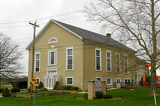
Penns Neck Baptist Church is a historic church, opened in 1812, on US 1 at Washington Road in Penns Neck, West Windsor Township, Mercer County, New Jersey, United States. The church was added to the National Register of Historic Places in 1989.
Faggs Manor is an unincorporated community in Londonderry Township, Chester County, Pennsylvania, in the United States. The hamlet, at the corner of Street Road and Faggs Manor Road includes a church and cemetery with a few nearby houses.
Penns Neck is an unincorporated community located within West Windsor Township in Mercer County, New Jersey, United States. The community developed at the intersection of the Trenton-New Brunswick Turnpike and Washington Road. The Penns Neck Circle and the historic Penns Neck Baptist Church (1812) are both located in Penns Neck. The Princeton Branch rail line, known as the Dinky, has run through the area since 1865, and stopped at Penns Neck station until January 1971.
Artificial Island is a U.S. island located along the eastern shore of the Delaware River, mostly in southwestern New Jersey with a tiny portion inside Delaware's boundaries. It is part of both Lower Alloways Creek Township, Salem County, New Jersey and New Castle County, Delaware. The island is separated from mainland New Jersey by Alloway Creek and Hope Creek. It is called "artificial" since portions of the island are composed of land reclaimed from Delaware Bay. An artificial island is an island constructed by man rather than created by natural means.
The Township Act of 1798 is an Act passed by New Jersey Legislature on February 21, 1798 that formally incorporated 104 municipalities in 13 counties in New Jersey. It set standards on format for government of townships. The act was largely replaced by subsequent laws.

Churchtown, historically known as Penns Neck, is an unincorporated community located north of Pennsville in Pennsville Township, Salem County, New Jersey. St. George's Episcopal Church was started here in 1714 by Swedish and Finnish settlers as a Lutheran church.
Penns Neck or Penn's Neck may refer to:
References
- 1 2 Snyder, John P. The Story of New Jersey's Civil Boundaries: 1606–1968, Bureau of Geology and Topography; Trenton, New Jersey; 1969. p. 216. Accessed December 11, 2012.