
Golden Township is a civil township of Oceana County in the U.S. state of Michigan. The population was 1,810 at the 2000 census.

Pentwater is a village in Oceana County in the U.S. state of Michigan. The population was 857 at the 2010 census. The village is located within Pentwater Township. Pentwater is home to Mears State Park. The name Pentwater comes from Pent or Penned up waters. The entrance to the channel is notoriously shallow and for many years dictated the size of vessels that the village was able to accommodate.
The Saco River is a river in northeastern New Hampshire and southwestern Maine in the United States. It drains a rural area of 1,703 square miles (4,410 km2) of forests and farmlands west and southwest of Portland, emptying into the Atlantic Ocean at Saco Bay, 136 miles (219 km) from its source. It supplies drinking water to roughly 250,000 people in thirty-five towns; and historically provided transportation and water power encouraging development of the cities of Biddeford and Saco and the towns of Fryeburg and Hiram. The name "Saco" comes from the Eastern Abenaki word [sɑkohki], meaning "land where the river comes out". The Jesuit Relations, ethnographic documents from the 17th century, refer to the river as Chouacoet.
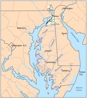
The Elk River is a tidal tributary of the Chesapeake Bay on the Eastern Shore of Maryland and on the northern edge of the Delmarva Peninsula. It is about 15 miles (24 km) long. As the most northeastern extension of the Chesapeake Bay estuary, it has served as one entrance to the Chesapeake & Delaware Canal since the 19th century. The canal and river now serve as one boundary of the Elk Neck Peninsula. The river flows through Cecil County, Maryland, with its watershed extending into New Castle County, Delaware and Chester County, Pennsylvania. Elkton, the county seat of Cecil County, is located at its head. Its total watershed area is 143 square miles (370 km2), with 21 square miles (54 km2) of open water, so its watershed is 15% open water. It is south and east of the North East River, and north of the Sassafras River.
Cold Water Spring State Preserve is a 60-acre (240,000 m2) parcel state preserve protecting a spring that issues from Cold Water Cave, an extensive cave system in Winneshiek County, Iowa and Fillmore County, Minnesota. The spring is a tributary of the Upper Iowa River.
The SS Anna C. Minch was a cargo carrier which foundered, broke in two, and sank in Lake Michigan during the Armistice Day Blizzard on 11 November 1940. The Anna C. Minch was a steam powered, steel hulled bulk freighter constructed in 1903 by the American Ship Building Company at Cleveland, Ohio.
The Whitefish River is an 11.9-mile-long (19.2 km) river on the Upper Peninsula of the U.S. state of Michigan. The mouth of the river is in Delta County at 45°54′34″N86°58′01″W on the Little Bay De Noc of Lake Michigan. The main branch of the river is formed by the confluence of the east and west branches at 46°03′25″N86°52′17″W.
WWKR is a radio station in Hart, Michigan, broadcasting a classic rock format. The station airs the satellite-fed "Rock Classics" format from Jones Radio Networks.

WMOM is a radio station formerly broadcasting a Top 40 (CHR)/Alternative hybrid format. Licensed to Pentwater, Michigan, it serves the Ludington, Michigan area. It first began broadcasting in 1999. The station is licensed, but currently dark.

The Betsie River is a 54.0-mile-long (86.9 km) stream in the northwest part of the U.S. state of Michigan. The name is derived from the French la rivière aux Bec-scies, meaning river of sawbill ducks (bec-scie). Other alternate names include Aug-sig-o-sebe, Aux Buscies, Betsey's River, Black Robe, Gay-she-say-ing, Riviere du Pere Marquette, Sawbill Ducks, and Shelldrake Ducks. The river is mostly within Benzie County, although the river rises in southwest Grand Traverse County and flows briefly through northern Manistee County, Michigan.
Ruby Creek is a 4.6-mile-long (7.4 km) tributary to the Big South Branch of the Pere Marquette River in western Michigan in the United States. The creek runs west to east in northern Oceana County, 13 miles (21 km) West-southwest of Baldwin, and is known as a lake run trout and salmon fishery.
The SS William B. Davock was a lake freighter that was constructed in 1907 by Great Lakes Engineering Works, at their St. Clair, Michigan facility for the Vulcan Steamship Co.. She was operated by Vulcan Steamship from 1907 to 1915 in the Great Lakes coal, iron ore, grain and stone trades. In 1915 the ship came under the management of the Interlake Steamship Co.. While laid up for the winter (1922–23) in Fairport, Ohio, she was reconstructed and updated; this work changed her tonnage to 4220 gross and 2671 net. The Davock resumed its traditional trade pattern of coal carried to ports in the upper lakes from Lake Erie and iron ore carried from Lake Superior ports to the steel mills of Lake Erie and Lake Michigan.
Pipestone Creek is a 53.2-mile-long (85.6 km) river in southwestern Minnesota, having a center branch as well as branches named "North" and "South". The creek begins about 3 miles (5 km) north of Holland and flows southwesterly, roughly following MN State Highway 23 for much of its early existence. The creek approaches the town of Pipestone from the east, but turns northwesterly just before Highway 23 meets U.S. Highway 75, with the creek going under both highways in rapid succession. Flowing through Pipestone National Monument, the creek passes over Winnewissa Falls, and then enters the adjacent State DNR controlled "Pipestone Wildlike Management Area" where a small "impoundment" (dam) forms "Indian Lake". The creek continues northwesterly until turning southwesterly just east of County Road 53. On the west side of County Rd 53, and on the North side of Country Rd 5, it is joined by the North branch, and on the south side of the same road, the South branch joins. The creek continues southwesterly, and crosses the state line in South Dakota above the road known as 81st Street in Minnesota and 236th A Street in South Dakota. It does not travel far into South Dakota, but loops back into Minnesota, flowing into Split Rock Creek within a mile of the state line, this confluence about 3 miles north of Sherman, South Dakota, also being 3 miles south of Jasper, Minnesota. Split Rock Creek itself is a tributary of the Big Sioux River, which in turn flows via the Missouri River and Mississippi River to the Gulf of Mexico.
The Lincoln River is a 7.8-mile-long (12.6 km) river in Mason County, Michigan, in the United States. It is formed by the confluence of its North and South branches 5 miles (8 km) northeast of Ludington and flows westward to Lake Michigan. Part of Lincoln river runs through a small private community called epworth
Sturgeon River is a 63.6-mile-long (102.4 km) river in the U.S. state of Michigan, flowing mostly southward through Alger County and Delta County counties on the Upper Peninsula.

Indian River is a 59.1-mile-long (95.1 km) tributary of the Manistique River on the Upper Peninsula of Michigan in the United States. It rises out of Hovey Lake at 46°17′36″N86°42′20″W on Hiawatha National Forest land in Alger County and flows south and east through a lake district and on through Schoolcraft County. The river flows into the 8,659 acre (35 km²) Indian Lake at 46°17′36″N86°42′20″W and flows out at 45°59′30″N86°17′15″W. It then flows east and south about 2.5 miles where it merges with the Manistique River, which then flows through Manistique and into Lake Michigan at 45°56′56″N86°14′45″W.
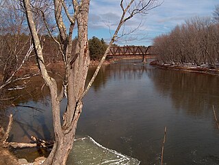
The US 31–Pentwater River Bridge is a three-span steel bridge that carries Oceana Drive over the Pentwater River in northern Hart, Michigan. It is listed on the National Register of Historic Places.

The Navigation Structures at Pentwater Harbor are navigational structures located at the west end of Lowell Street in Pentwater, Michigan. They were listed on the National Register of Historic Places in 2001.

Oceana County Historical & Genealogical Society is a historical society representing local history of Oceana County, Michigan. Its Research Headquarters and Library are located in Hart, Michigan. The organization runs Historical Park Museums located in Mears, Michigan, about 4 miles away.


