
Rhys ap Gruffydd or ap Gruffudd was the ruler of the kingdom of Deheubarth in south Wales from 1155 to 1197. Today, he is commonly known as The Lord Rhys, in Welsh Yr Arglwydd Rhys, although this title may have not been used in his lifetime. He usually used the title "Proprietary Prince of Deheubarth" or "Prince of South Wales", but two documents have been discovered in which he uses the title "Prince of Wales" or "Prince of the Welsh". Rhys was one of the most successful and powerful Welsh princes, and, after the death of Owain Gwynedd of Gwynedd in 1170, the dominant power in Wales.

Meirionnydd is a coastal and mountainous region of Wales. It has been a kingdom, a cantref, a district and, as Merionethshire, a county.

Newcastle Emlyn is a town on the River Teifi, straddling the counties of Ceredigion and Carmarthenshire in west Wales. It is also a community entirely within Carmarthenshire, bordered by those of Llangeler and Cenarth, both being in Carmarthenshire; and by Llandyfriog in Ceredigion. Adpar is the part of the town that lies on the Ceredigion side of the River Teifi. It was formerly called Trefhedyn and was an ancient Welsh borough in its own right.

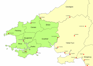
Seisyllwg was a petty kingdom of medieval Wales. It is unclear when it emerged as a distinct unit, but according to later sources it consisted of the former Kingdom of Ceredigion plus the region known as Ystrad Tywi. Thus it covered the modern county of Ceredigion, part of Carmarthenshire, and the Gower Peninsula. It is evidently named after Seisyll, king of Ceredigion in the 7th or early 8th century, but it is unknown if he was directly responsible for its establishment. In the 10th century Seisyllwg became the center of power for Hywel Dda, who came to rule most of Wales. In 920 Hywel merged Seisyllwg with the Kingdom of Dyfed to form the new kingdom of Deheubarth.
Rhain ap Cadwgan was an 8th-century king of Dyfed and Brycheiniog in Wales of the Early Middle Ages. He succeeded his father Cadwgan, who succeeded his father Caten ap Cloten.
The Kingdom of Dyfed is one of several Welsh petty kingdoms that emerged in 5th-century sub-Roman Britain in southwest Wales based on the former territory of the Demetae. Following the Norman invasion of Wales between 1067–1100, the region was conquered by the Normans and by 1138 incorporated into a new shire called Pembrokeshire after the Norman castle built in the Cantref of Penfro and under the rule of the Marcher Earl of Pembroke.
Ystrad Tywi is a region of southwest Wales situated on the both banks of the River Tywi. Although Ystrad Tywi was never a kingdom itself, it was historically a valuable territory and was fought over by the various kings of Dyfed, Deheubarth, Seisyllwg, Gwynedd, Morgannwg and the Normans.

Cynwyl Gaeo is a parish and community located in rural Carmarthenshire, Wales, near the boundary with Ceredigion, in the upper Cothi valley about halfway between Lampeter and Llandovery. The population of the village at the United Kingdom Census 2011 was 940. It includes the villages of Caeo, Crug-y-bar, Cwrtycadno, Ffarmers and Pumsaint.
Ysgol Gyfun Gymunedol Penweddig is a Welsh-language, community comprehensive school situated in Llanbadarn Fawr, Aberystwyth, Wales. The school was established in 1973. The school was the first Welsh language secondary school in Ceredigion and is named after the cantref of Penweddig, the northern part of the Kingdom of Ceredigion, between the rivers Dyfi and Ystwyth.

Llandre, or Llanfihangel Genau'r Glyn, is a village in Ceredigion, Wales. It lies 5 miles north of Aberystwyth in the north-west of the county, on the road from Rhydypennau to Borth. To the north lies the village of Dôl-y-bont. The community is called Geneu'r Glyn.

Erwood is a village lying beside the River Wye, on the A470 road some 6 miles south-east of Builth Wells in Powys, Wales. The population of the community taken at the 2011 census was 429. It is in the historic county of Brecknockshire (Breconshire) and the older cantref of Cantref Selyf.

Creuddyn was a medieval commote and, later, a lordship in Ceredigion, Wales. It was located between the rivers Ystwyth and Rheidol, and was one of the three commotes of Cantref Penweddig. The name, of Old Welsh origin, probably refers to the Pen Dinas hill fort, anciently known as Dinas Maelor. The natural centre of the commote was Llanfihangel y Creuddyn where five roads meet at the village. The name survives in the name of a rural community and church of the same name; however the modern community is much smaller than the medieval commote.
Castell Gwallter, also known as Walter's Castle and sometimes Castell Penweddig, is the remains of a Norman motte-and-bailey castle situated on a large hill above the old village of Llandre in northern Ceredigion, Wales, four miles northeast of Aberystwyth.
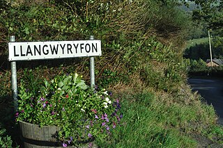
Llangwyryfon is a village and community in the county of Ceredigion, Wales. It lies on the B4576 about 8 miles to the south and east of Aberystwyth. The village lies in the valley of the River Wyre and contains the roadbridge where the B4576 crosses the Wyre downstream of which lies the confluence of the rivers Beidiog and the Wyre. The name Llangwyryfon derives from the tale of Saint Ursula to whom the village church is dedicated. Llan is Welsh for church and the gwyryddon are the 11,000 virgins who Ursula was martyred along with.
Caerwedros was a medieval commote in the south of the Kingdom of Ceredigion. With Mebwynion, Gwynionydd and Is Coed, Caerwedros was one of three cantref Is Aeron commotes.

Cyfeiliog was a medieval commote in the cantref of Cynan of the Kingdom of Powys. Cynan also contained the commote of Mawddwy. Other sources refer to Cyfeiliog as a cantref in its own right, possibly as a result of Cynan being renamed for the largest commote within it.


