
The Adirondack Mountains form a massif in northeastern New York with boundaries that correspond roughly to those of Adirondack Park. They cover about 5,000 square miles (13,000 km2). The mountains form a roughly circular dome, about 160 miles (260 km) in diameter and about 1 mile (1,600 m) high. The current relief owes much to glaciation. There are more than 200 lakes around the mountains, including Lake George, Lake Placid, and Lake Tear of the Clouds, which is the source of the Hudson River. The Adirondack Region is also home to hundreds of mountain summits, with some reaching heights of 5,000 feet or more.

The Thousand Islands – Frontenac Arch region or the Frontenac Axis is an exposed strip of Precambrian rock in Canada and the United States that links the Canadian Shield from Algonquin Park with the Adirondack Mountain region in New York, an extension of the Laurentian mountains of Québec. The Algonquin to Adirondacks region, which includes the Frontenac Axis or Arch, is a critical linkage for biodiversity and resilience, and one with important conservation potential. The axis separates the St. Lawrence Lowlands and the Great Lakes Lowlands. It has many distinctive plant and animal species. It is one of four ecoregions of the Mixedwood Plains.

The Adirondack Park is a part of New York's Forest Preserve in northeastern New York, United States. The park was established in 1892 for "the free use of all the people for their health and pleasure", and for watershed protection. The park's boundary roughly corresponds with the Adirondack Mountains. Unlike most state parks, about 52 percent of the land is privately owned inholdings. State lands within the park are known as Forest Preserve. Land use on public and private lands in the park is regulated by the Adirondack Park Agency. This area contains 102 towns and villages, as well as numerous farms, businesses and an active timber-harvesting industry. The year-round population is 132,000, with 200,000 seasonal residents. The inclusion of human communities makes the park one of the great experiments in conservation in the industrialized world. The Forest Preserve was designated a National Historic Landmark in 1963.

The Catskill Park is in the Catskill Mountains in New York in the United States. It consists of 700,000 acres of land inside a Blue Line in four counties: Delaware, Greene, Sullivan, and Ulster. As of 2005, 287,500 acres (116,300 ha) or 41 percent of the land within, is owned by the state as part of the Forest Preserve; it is managed by the Department of Environmental Conservation (DEC). Another 5% is owned by New York City to protect four of the city's reservoirs in the region that lie partially within the park and their respective watersheds.

The Oswegatchie River is a 137-mile-long (220 km) river in northern New York that flows from the Adirondack Mountains north to the Saint Lawrence River. The Oswegatchie River begins at Partlow Lake in Hamilton County, New York. The river continues through Cranberry Lake which was 'doubled in size' through construction of a dam in the late 1860s. The river continues from the dam to Gouverneur, to near Talcville in St. Lawrence County, where it joins the West Branch. Much of it is within Adirondack State Park. The city of Ogdensburg developed at the mouth of the river at its confluence with the St. Lawrence.

New York's Forest Preserve, comprises almost all the lands owned by the state of New York within the Adirondack and Catskill parks. It is managed by the state Department of Environmental Conservation (DEC).

The Dix Mountain Wilderness Area is the name previously given to an area of New York's Forest Preserve in the Adirondack Park, and is located in the towns of Elizabethtown, Keene and North Hudson, Essex County. It is roughly bounded on the north by NY 73, on the east by the Adirondack Northway (Interstate 87), on the south by Blue Ridge Road and on the west by Elk Lake Club and Ausable Club lands.
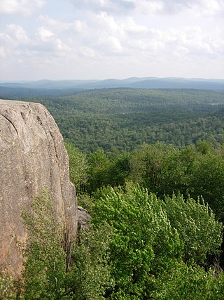
The Five Ponds Wilderness Area, an Adirondack Park unit of New York's Forest Preserve, is located in the towns of Fine and Clifton in St. Lawrence County, the town of Webb in Herkimer County and the town of Long Lake in Hamilton County. It includes 1,064 acres (4.3 km2) of private inholdings, 99 bodies of water covering 1,964 acres (7.9 km2), 57.9 miles (93.2 km) of trails, and 14 lean-tos.
The High Peaks Wilderness Area, the largest Forest Preserve unit in the U.S. state of New York, is located in three counties and six towns in the Adirondack Park: Harrietstown in Franklin County, North Elba, Keene, North Hudson and Newcomb in Essex County and Long Lake in Hamilton County.
The Ha-De-Ron-Dah Wilderness Area, an Adirondack Park unit of New York's Forest Preserve, is located in the town of Webb, Herkimer County, and the Town of Greig, Lewis County. It is bounded on the north by private lands in the vicinity of North Pond, Hitchcock Pond, Moose Pond and the headwaters of the Independence River; on the east by private lands along the Remsen to Lake Placid railroad right-of-way; on the south by private lands along NY 28 and by the wood road leading to the Copper Lake property; and on the west by Pine Creek and a DEC maintained foot trail from Pine Creek to Pine Lake, East Pine Pond, and Big Otter Lake.
The McKenzie Mountain Wilderness Area, an Adirondack Park unit of the Forest Preserve, lies in western Essex County in the towns of St. Armand, North Elba and Wilmington. In general, the Saranac River and Franklin Falls Pond border on the north; the Wilmington-Franklin Falls road, the Whiteface Mountain Memorial Highway and the west branch of the Ausable River form the eastern boundary; the Saranac Lake-Lake Placid Road, NY 86, forms the southern boundary; and the Saranac River forms the western boundary.
The Pharaoh Lake Wilderness Area, an Adirondack Park unit of New York's Forest Preserve, straddles the Essex County-Warren County line in the towns of Ticonderoga, Hague, Horicon and Schroon. The county road along the east shore of Schroon Lake forms the western boundary; to the north, private land and NY 74 form the boundary. The state land boundary forms most of the remaining perimeter except for a stretch of NY 8 on the south.
The Pigeon Lake Wilderness Area, an Adirondack Park unit of the forest preserve, lies in the town of Webb, Herkimer County, and the towns of Long Lake and Inlet in Hamilton County. It is bounded on the north by Stillwater Reservoir and large blocks of private land in the vicinity of Rose Pond, Shingle Shanty Pond and Upper Sister Lake; on the east by a private road from Brandreth Lake to North Point and by Raquette Lake; on the south by private lands along the Uncas Road; and on the west by the Big Moose Road, private lands near Big Moose Lake, Thirsty Pond, Twitchell Lake, Razorback Pond, and the Remsen to Lake Placid railroad tracks.
The Sentinel Range Wilderness Area, an Adirondack Park unit of New York's Forest Preserve, is located in the towns of Wilmington, North Elba and Keene, Essex County. It is bounded by NY 86 on the north, NY 73 on the south, and private lands on the east and west.
The Siamese Ponds Wilderness Area, an Adirondack Park unit of the Forest Preserve, is located in the towns of Lake Pleasant, Wells and Indian Lake in Hamilton County and the towns of Johnsburg and Thurman in Warren County. It is one of the larger wilderness areas of the Northeast; extending about 18 miles (29 km) from north to south and about 13 miles (21 km) from east to west at its widest part.
The Silver Lake Wilderness Area, an Adirondack Park unit of the Forest Preserve, is located in the towns of Lake Pleasant, Benson, Wells and Arietta in Hamilton County and is roughly bounded on the north by NY 8 and private lands near Piseco Lake, Oxbow Lake, Hamilton Lake, Sand Lake and Lake Pleasant; on the east by NY 30; on the south generally by the Hamilton County line; and on the west by NY 10, the West Branch of the Sacandaga River and the Piseco Outlet.
The West Canada Lake Wilderness Area is an Adirondack Park Forest Preserve management unit in the State of New York, USA.
The William C. Whitney Wilderness Area, an Adirondack Park unit of New York's Forest Preserve, is located in the town of Long Lake, Hamilton County. It is bounded on the east by Hamilton County Route 10, on the south by lands of Whitney Industries, on the west by private lands owned by The Nature Conservancy and the Brandreth Park Association, on the northwest by the Remsen to Lake Placid Railroad right-of-way, and on the north by other private land holdings. The area contains 12 bodies of water covering 4,286 acres (17.34 km2) and 20 miles (32 km) of foot trails. The area is named for William C. Whitney, who was an American political leader and financier.

The Moose River Plains Wild Forest is a 64,322-acre tract in the Adirondack Park in Hamilton and Herkimer counties in the state of New York in the United States of America; it is designated as Wild Forest by the New York State Department of Environmental Conservation.

High Falls is a small but picturesque waterfall on the upper Oswegatchie River in the Five Ponds Wilderness. It is located in the town of Fine, in a remote part of Adirondack State Park in St. Lawrence County. The falls drops about 20 feet (6.1 m). Access is by canoe or by maintained hiking trails. The closest public road, near Wanakena, is almost six miles to the north. Trail access is by a short spur from the High Falls Loop Trail. The most direct canoe access is by way of the Oswegatchie River from the Oswegatchie River Inlet on Inlet Road. The waterfall has been designated a scenic special interest area in the New York State Land Master Plan.
