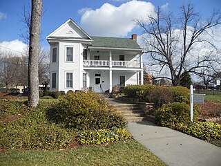
Dunwoody is a city located in DeKalb County, Georgia, United States. As a northern suburb of Atlanta, Dunwoody was incorporated as a city on December 1, 2008 but its area establishment dates back to the early 1830s. As of 2018, the city has a population of 49,459, up from 46,267 in the 2010 Census.
In Downtown Atlanta, the Downtown Connector or I-75/85 is the concurrent section of Interstate 75 and Interstate 85 through the core of the city. Beginning at the I-85/Langford Parkway interchange, the Downtown Connector runs generally due north, meeting the west–east I-20 in the middle. Just north of this is the Grady Curve around Grady Memorial Hospital. Continuing north, the terminus of the Downtown Connector is the Brookwood Interchange or Brookwood Split in the Brookwood area of the city. The overall length of the Downtown Connector is approximately 7.5 miles (12 km). Since the 2000s, it has been officially named James Wendell George Parkway for most of its length, although it is still designated the Connector in the mainstream. It also has unsigned designations State Route 401 (I-75) and State Route 403 (I-85) along its length, due to I-75 and I-85 having a 400-series reference numbers.

Georgia State Route 400 is a freeway and state highway in the U.S. state of Georgia serving parts of Metro Atlanta. It is concurrent with U.S. Route 19 (US 19) from exit 4 (Interstate 285) until its northern terminus south-southeast of Dahlonega, linking the city of Atlanta to its north-central suburbs and exurbs. SR 400 travels from the Lindbergh neighborhood in the Buckhead district of Atlanta, at Interstate 85 (I-85), to just south-southeast of Dahlonega. Like the Interstate highways, it is a limited-access road, but unlike the interstates, the exit numbers are not mileage-based, they are sequential. Once SR 400 passes exit 17 (SR 306), it changes from a limited-access freeway into an at-grade divided highway with traffic lights, but still with a high speed limit of 65 miles per hour (105 km/h), and ends at the J.B. Jones Intersection at SR 60/SR 115 in Lumpkin County.
Interstate 520 (I-520) is a 23.34-mile (37.56 km) auxiliary Interstate Highway that encircles most of Augusta, Georgia, and North Augusta, South Carolina as a three-quarter beltway around the western, southern, and eastern parts of the main part of the Augusta metropolitan area. It begins at I-20 and State Route 232 (SR 232) in the northern part of Augusta, and ends at I-20 in the northern part of North Augusta, South Carolina. I-520 is also known as Bobby Jones Expressway and the Deputy James D. Paugh Memorial Highway in Georgia and Palmetto Parkway in South Carolina. On the Georgia side, the road also carries the internal designation State Route 415.

The Georgia Department of Transportation (GDOT) is the organization in charge of developing and maintaining all state and federal roadways in the U.S. state of Georgia. In addition to highways, the department also has a limited role in developing public transportation and general aviation programs. GDOT is headquartered in downtown Atlanta and is part of the executive branch of state government.

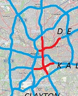
Interstate 485 (I-485) was a proposed Auxiliary Interstate Highway, that would have traveled eastward and then northward from downtown Atlanta, in the U.S. state of Georgia.

Buckhead is a train station in Atlanta, Georgia, serving the Red Line of the Metropolitan Atlanta Rapid Transit Authority (MARTA) rail system. This station is the first station only served by the Red Line. It is located in the Buckhead neighborhood in the median of State Route 400, a limited access highway, at Peachtree Road/State Route 141. The station is in easy walking distance of many offices, hotels and shopping centers, including Lenox Square, although the Lenox MARTA station provides easier access to the mall. The buc, a zero-fare bus service, also provides transportation to the surrounding area. The Buckhead Station also features Zipcars.

Indian Creek is a train station in unincorporated DeKalb County, Georgia, the eastern terminus of the Blue Line of the Metropolitan Atlanta Rapid Transit Authority (MARTA) rail system. It has an island platform with one track on each side of the platform. This station opened in June 1993.

Sandy Springs is an underground metro station in Sandy Springs, Georgia, on the Red Line of the Metropolitan Atlanta Rapid Transit Authority (MARTA) rail system. It serves the Perimeter Center area, including high-rise office parks near Georgia 400 and Abernathy Road, north of Perimeter Mall and within the recently incorporated city of Sandy Springs, the Art Institute of Atlanta, American Intercontinental University, United Parcel Service, North Park business park, Embassy Row and Cox Communications.
Interstate 75 (I-75) in the U.S. state of Georgia travels north–south along the U.S. Route 41 (US 41) corridor on the western side of the state, traveling through the cities of Valdosta, Macon, and Atlanta. It is also designated—but not signed—as State Route 401 (SR 401).
Interstate 85 (I-85) is a major Interstate Highway that travels northeast-to-southwest in the U.S. state of Georgia. It enters the state at the Alabama state line near West Point, and Lanett, Alabama, traveling through the Atlanta metropolitan area and to the South Carolina state line, where it crosses the Savannah River near Lake Hartwell. I-85 connects northern Georgia with Montgomery, Alabama, to the southwest, and with South Carolina, North Carolina, and Virginia to the northeast. Within Georgia, I-85 is also designated as the unsigned State Route 403 (SR 403).
The Outer Perimeter is a freeway originally planned to encircle Atlanta, in the U.S. state of Georgia about 20 to 25 miles outside of Interstate 285, which is colloquially referred to as the Perimeter and is a point of reference for local travel outside Atlanta's city core.
In the U.S. state of Georgia, Interstate 20 (I-20) travels from the Alabama state line to the Savannah River, which is the South Carolina state line. The highway enters the state near Tallapoosa. It travels through the Atlanta metropolitan area and exits the state in Augusta. The highway also travels through the cities of Bremen, Douglasville, Conyers, Covington, and Madison. I-20 has the unsigned state highway designation of State Route 402 (SR 402).
The transportation system of Georgia is a cooperation of complex systems of infrastructure comprising over 1,200 miles (1,900 km) of interstates and more than 120 airports and airbases serving a regional population of 59,425 people.

There have been multiple freeway revolts in Atlanta, Georgia. However, the longest and most famous example of Interstate opposition is against I-485 and the Stone Mountain Freeway through Intown Atlanta, lasting over 30 years, from the early 1960s until the final construction of Freedom Parkway on a small portion of the contested routes in 1994.


