
The Dwight D. Eisenhower National System of Interstate and Defense Highways, commonly known as the Interstate Highway System, or the Eisenhower Interstate System, is a network of controlled-access highways that forms part of the National Highway System in the United States. The system extends throughout the contiguous United States and has routes in Hawaii, Alaska, and Puerto Rico.
The Alaska Highway was constructed during World War II to connect the contiguous United States to Alaska across Canada. It begins at the junction with a few Canadian highways in Dawson Creek, British Columbia, and runs to Delta Junction, Alaska, via Whitehorse, Yukon. When it was completed in 1942, it was about 2,700 kilometres (1,700 mi) long, but in 2012, it was only 2,232 km (1,387 mi). This is due to the realignments of the highway over the years, which has rerouted and straightened many sections. The highway opened to the public in 1948. Once legendary for being a rough, challenging drive, the highway is now paved over its entire length. Its component highways are British Columbia Highway 97, Yukon Highway 1, and Alaska Route 2.

Interstate 296 (I-296) is a part of the Interstate Highway System in the US state of Michigan. It is a north–south state trunkline highway that runs for 3.43 miles (5.52 km) entirely within the Grand Rapids area. Its termini are I-196 near downtown Grand Rapids and I-96 on the north side of Grand Rapids in Walker. For most of its length, the Interstate runs concurrently with U.S. Highway 131 (US 131), which continues as a freeway built to Interstate Highway standards north and south of the shorter I-296. The highway was first proposed in the late 1950s and opened in December 1962, but the Michigan Department of Transportation (MDOT) has since eliminated all signage for I-296 and removed the designation from their official state map. The designation is therefore unsigned, but still listed on the Interstate Highway System route log maintained by the Federal Highway Administration (FHWA).
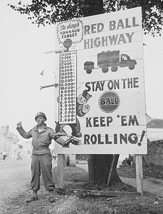
The Red Ball Express was a famed truck convoy system that supplied Allied forces moving quickly through Europe after breaking out from the D-Day beaches in Normandy in 1944. To expedite cargo shipment to the front, trucks emblazoned with red balls followed a similarly marked route that was closed to civilian traffic. The trucks also had priority on regular roads.
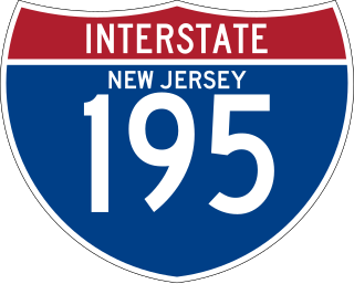
Interstate 195 (I-195), known also as the Central Jersey Expressway, is an auxiliary route of the Interstate Highway System located in the US state of New Jersey. Its western end is at I-295 and Route 29 just south of Trenton in Hamilton, Mercer County, while its eastern end is at the Garden State Parkway, Route 138, and Route 34 in Wall Township, Monmouth County. I-195 is 34.1 miles (54.9 km) in length. The route is mostly a four-lane highway that mainly runs through agrarian and wooded areas in Central Jersey. It has an interchange with the New Jersey Turnpike (I-95) in Robbinsville and serves as a main access road to New Jersey's state capital of Trenton, the Horse Park of New Jersey, the Six Flags amusement park, and the Jersey Shore. On April 6, 1988, President Ronald Reagan signed H.R. 4263 naming I-195 in New Jersey the James J. Howard Interstate Highway, in honor of the late James J. Howard.

Interstate 275 (I-275) is an auxiliary Interstate Highway in the US state of Michigan that acts as a western bypass of the Detroit metropolitan area. The Michigan Department of Transportation (MDOT) maintains the highway as part of the larger State Trunkline Highway System. The freeway runs through the western suburbs near Detroit Metropolitan Wayne County Airport, and crosses several rivers and rail lines in the area. The southern terminus is the interchange with I-75 near Newport, northeast of Monroe. MDOT considers the Interstate to run to an interchange with I-96, I-696 and M-5 on the Farmington Hills–Novi city line, running concurrently with I-96 for about five miles (8.0 km). This gives a total length of about 35.03 miles (56.38 km), which is backed up by official signage. According to the Federal Highway Administration (FHWA), the length is 29.97 miles (48.23 km) because that agency considers I-275 to end at the junction with I-96 and M-14 along the boundary between Livonia and Plymouth Township. All other map makers, like the American Automobile Association, Rand McNally and Google Maps follow MDOT's practice.

Interstate 14 (I-14), also known as the 14th Amendment Highway, the Gulf Coast Strategic Highway, and the Central Texas Corridor, is an Interstate Highway that is currently located entirely in Central Texas, following US Highway 190 (US 190). The portion of the route that has been constructed and signed to date, the Central Texas Corridor along US 190 west of I-35 was officially designated as I-14 by the Fixing America's Surface Transportation Act, signed by President Barack Obama on December 14, 2015.

State Route 401 is a state highway in Pershing County, Nevada. The route, known as Rye Patch Road, serves the Rye Patch State Recreation Area.

The National Highway System (NHS) is a network of strategic highways within the United States, including the Interstate Highway System and other roads serving major airports, ports, military bases, rail or truck terminals, railway stations, pipeline terminals and other strategic transport facilities. Altogether, it constitutes the largest highway system in the world.

U.S. Route 60 (US 60) is a major U.S. Highway in the American state of Kentucky. In the early days of the U.S. Highway System, US 60 was originally to be numbered as US 62. Following extensive lobbying and complaints filed by Kentucky governor William J. Fields to the American Association of State Highway Officials, the route was re-designated as US 60 before the system was finalized. In Kentucky, US 60 parallels the Ohio River. US 60 enters Kentucky from Cairo, Illinois, traveling northeast to Louisville, then takes a direct eastward route to rejoin the Ohio River in downtown Ashland, Kentucky. Both US 60 and US 23 run concurrently from Ashland to Catlettsburg where US 60 turns east and enters Kenova, West Virginia. US 60 is the longest route in Kentucky, running 495 miles (797 km) across the width of the state, passing through 22 of Kentucky's counties and through the cities of Paducah, Henderson, Owensboro, Louisville, the state capital of Frankfort, and Lexington.
Transportation in New York is made up of some of the most extensive and one of the oldest transportation infrastructures in the country. Engineering difficulties because of the terrain of the State of New York and the unique issues of New York City brought on by urban crowding have had to be overcome since the state was young. Population expansion of the state generally followed the path of the early waterways, first the Hudson River and then the Erie Canal. Today, railroad lines and the New York State Thruway follow the same general route.
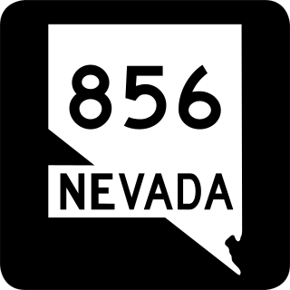
State Route 856 is a state highway in Pershing County, Nevada serving Lovelock. The western portion of the route is also signed as Interstate 80 Business.
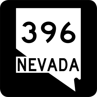
State Route 396 is a state highway in Pershing County, Nevada serving the city of Lovelock. The highway forms a portion of Interstate 80 Business within the city of Lovelock, and previously carried the alignment of former U.S. Route 40 and U.S. Route 95.

The State Trunkline Highway System consists of all the state highways in Michigan, including those designated as Interstate, United States Numbered, or State Trunkline highways. In their abbreviated format, these classifications are applied to highway numbers with an I-, US, or M- prefix, respectively. The system is maintained by the Michigan Department of Transportation (MDOT) and comprises 9,669 miles (15,561 km) of trunklines in all 83 counties of the state on both the Upper and Lower peninsulas, which are linked by the Mackinac Bridge. Components of the system range in scale from 10-lane urban freeways with local-express lanes to two-lane rural undivided highways to a non-motorized highway on Mackinac Island where cars are forbidden. The longest highway is nearly 400 miles (640 km) long, while the shortest is about three-quarters of a mile. Some roads are unsigned highways, lacking signage to indicate their maintenance by MDOT; these may be remnants of highways that are still under state control whose designations were decommissioned or roadway segments left over from realignment projects.

The Arkansas Highway System is made up of all the highways designated as Interstates, U.S. Highways and State Highways in the US state of Arkansas. The system is maintained by the Arkansas Department of Transportation (ArDOT), known as the Arkansas State Highway Department (AHD) until 1977 and the Arkansas State Highway and Transportation Department (AHTD) from 1977 to 2017. The system contains 16,442.90 miles (26,462.28 km) of Interstates, U.S. Routes, state highways, and special routes. The shortest members are unsigned state highways Arkansas Highway 806 and Arkansas Highway 885, both 0.09 miles (0.14 km) in length. The longest route is U.S. Route 67, which runs 296.95 miles (477.89 km) from Texarkana to Missouri.
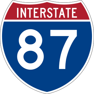
Interstate 87 (I-87) is a partially completed Interstate Highway in the US state of North Carolina, the shortest designated primary Interstate Highway at 12.90 miles (20.76 km) long. The completed portion is in eastern Wake County, between Raleigh and Wendell; the majority of the completed route is known as the Knightdale Bypass, while the remaining three miles (4.8 km) follows the Raleigh Beltline (I-440). It is planned to continue northeast through Rocky Mount, Williamston, and Elizabeth City, ending in Norfolk, Virginia. It is signed as north–south, in keeping with the sign convention for most odd-numbered interstates, but the route goes primarily east–west, with the eastern direction aligning to the north designation. The entire route is concurrent with U.S Highway 64 (US 64), with portions also concurrent with I-440 and US 264.
