Related Research Articles

Alagoas is one of the 27 federative units of Brazil and is situated in the eastern part of the Northeast Region. It borders: Pernambuco ; Sergipe (S); Bahia (SW); and the Atlantic Ocean (E). Its capital is the city of Maceió. It has 1.6% of the Brazilian population and produces 0.8% of the Brazilian GDP. It is made up of 102 municipalities and its most populous cities are Maceió, Arapiraca, Palmeira dos Índios, Rio Largo, Penedo, União dos Palmares, São Miguel dos Campos, Santana do Ipanema, Delmiro Gouveia, Coruripe, Marechal Deodoro, and Campo Alegre.

The Pernambuco coastal forests is an ecoregion of the Tropical moist broadleaf forests Biome, and the South American Atlantic Forest biome. It is located in northeastern Brazil.
The Mundaú River is a river in northeastern Brazil. The Mundaú originates in the Borborema Plateau of Pernambuco state, and flows southeast through Pernambuco and Alagoas states to empty into the Mundaú Lagoon at Maceió, Alagoas' capital. Mundaú Lagoon is an estuary, connected to the Atlantic Ocean and Manguaba Lagoon to the south by a network of channels.

The Moxotó River is a tributary of the São Francisco River in northeastern Brazil. The Moxotó originates on the Borborema Plateau in Pernambuco state, and flows southwest to join the São Francisco. The lower portion of the river forms the border between Pernambuco state to the west and Alagoas state to the east.

The Pajeú River is a tributary of the São Francisco River in the state of Pernambuco in northeastern Brazil. The Pajeú originates on the Borborema Plateau, and flows 353 kilometres (219 mi) southwest to join the São Francisco. It has a total watershed of 16,685.63 square kilometres (6,442.36 sq mi), which represents 16.97% of the total area of the state of Pernambuco.

The "Pernambuco" interior forests is an ecoregion of the Tropical and subtropical moist broadleaf forests Biome, and the South American Atlantic Forest biome. It lies in eastern Brazil between the coastal Pernambuco coastal forests and the dry Caatinga shrublands of Brazil's interior.
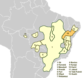
The Karirí languages, generally considered dialects of a single language, were a group of languages formerly spoken by the Kiriri people of Brazil. It was spoken until the middle of the 20th century; the 4,000 ethnic Kiriri are now monolingual Portuguese speakers, though a few know common phrases and names of medicinal plants.
The Inhumas or Inhaúma River is a river of Alagoas and Pernambuco states in eastern Brazil. It is the main tributary of the Canhoto River.

Ipanema River is a river of Alagoas and Pernambuco states in eastern Brazil.
Traipu River is a river of Alagoas and Pernambuco states in eastern Brazil.
Tacaratu is a municipality in the state of Pernambuco, Brazil. The population in 2020, according with IBGE is 26,106 and the area is 1264.5 km2.
Maraial is a city in Pernambuco, Brazil. It is located in Zona da mata Pernambucana, 154 km from the state capital, Recife.

Bom Conselho is a city in northeastern Brazil, in the state of Pernambuco. It lies in the mesoregion of Agreste of Pernambuco and has 786.2 sq/km of total area.

Quipapá is a city located in the state of Pernambuco, Brazil. Located at 186 km away from Recife, capital of the state of Pernambuco. Has an estimated population of 26,175 inhabitants.

Canhotinho is a city located in the state of Pernambuco, Brazil. Located at 223 km away from Recife, capital of the state of Pernambuco. Has an estimated population of 24,773 inhabitants.
Itaíba is a city located in the state of Pernambuco, Brazil. It is located 306 km away from Recife, the capital of the state of Pernambuco. It has an estimated population of 26,308 inhabitants.

Glória is a municipality in the state of Bahia in the North-East region of Brazil. Glória covers 1,255.56 km2 (484.77 sq mi), and has a population of 15,234 with a population density of 13 inhabitants per square kilometer. It is located on the border of the states of Bahia, Pernambuco, and Alagoas on the banks of the Moxito River, now a lake as the result of the construction of Moxito Hydroelectric Power Plant.

Events in the year 1981 in Brazil.
The Jacuípe River is a river along the border between Alagoas and Pernambuco states in eastern Brazil. It flows into the Una River on the border of Barreiros and Água Preta municipalities in the latter state.
The Canhoto River is a river of Pernambuco and Alagoas states in eastern Brazil. It is the main tributary of the Mundaú River.