This article needs additional citations for verification .(August 2018) |
This article needs additional citations for verification .(August 2018) |
The 24th congressional district of Ohio was created for the 1966 election, after the banning of at-large seats by the Voting Rights Act of 1965. It replaced Ohio's at-large congressional district. It was eliminated in the redistricting following the 1970 census. At the time of its creation, it consisted of the southwestern counties of Preble, Butler, Warren and parts of southern and eastern Montgomery.
Skelton Glacier is a large glacier flowing from the polar plateau into the Ross Ice Shelf at Skelton Inlet on the Hillary Coast, south of Victoria Land, Antarctica.

The Molucca Sea is located in the western Pacific Ocean, around the vicinity of Indonesia, specifically bordered by the Indonesian Islands of Celebes (Sulawesi) to the west, Halmahera to the east, and the Sula Islands to the south. The Molucca Sea has a total surface area of 77,000 square miles. The Molucca Sea is rich in coral and has many diving sites due to the deepness of its waters. The deepness of the water explains the reasoning behind dividing the sea into three zones, which functions to transport water from the Pacific Ocean to the shallower seas surrounding it. The deepest hollow in the Molucca Sea is the 15,780-foot (4,810-meter) Batjan basin. This region is known for its periodic experiences of earthquakes, which stems from the sea itself being a micro plate, in which the Molucca Sea is being subducted in two opposite directions: one in the direction of the Eurasian Plate to the west and the other in the direction of the Philippine Sea Plate to the east.
Mount Pye is a rugged hill in the southeast of the South Island of New Zealand. It is the highest point in the area known as the Catlins, rising to 720 m (2361 ft). It is located 40 km (25 mi) southeast of Gore, and forms part of the border between the Otago and Southland regions. The headwaters of many of the Catlins' rivers are located on the slopes of Mount Pye.

The Sankuru River is a major river in the Democratic Republic of the Congo. Its approximate length of 1,200 km makes it the longest tributary of the Kasai River.
Antsakanalabe is a town and commune in Madagascar. It belongs to the district of Befandriana-Nord, which is a part of Sofia Region. The population of the commune was estimated to be approximately 11,000 in 2001 commune census.
Systerflesene Islands is a group of three small islands lying 5 miles (8 km) west of Hamnenabben Head in the east part of Lutzow-Holm Bay. Mapped by Norwegian cartographers from air photos taken by the Lars Christensen Expedition, 1936–37, and named "Systerflesene".
The Porthos Range is the second range south in the Prince Charles Mountains of Antarctica, extending for about 30 miles in an east-to-west direction between Scylla Glacier and Charybdis Glacier. First visited in December 1956 by the Australian National Antarctic Research Expeditions (ANARE) southern party under W.G. Bewsher (1956-57) and named after Porthos, a character in Alexandre Dumas, père's novel The Three Musketeers, the most popular book read on the southern journey.
Dukat is a village in the municipality of Bosilegrad, Serbia. According to the 2002 census, the town has a population of 397 people.
Alexander Hill is a 220-metre (720 ft) hill with a prominent seaward cliff face, lying south of Harrison Stream and Cinder Hill on the lower ice-free west slopes of Mount Bird, Ross Island, Antarctica. It was mapped by the New Zealand Geological Survey Antarctic Expedition, 1958–59, and named by the New Zealand Antarctic Place-Names Committee for B.N. Alexander, a surveyor with the expedition.

Brown Peninsula is a nearly ice-free peninsula, 10 nautical miles (19 km) long and 4 nautical miles (7 km) wide, which rises above the Ross Ice Shelf northward of Mount Discovery, to which it is connected by a low isthmus. It was discovered by the British National Antarctic Expedition, 1901–04, which named it "Brown Island" because of its color and its island-like character. Since it is a peninsula, the name has been altered accordingly.
Chambers Glacier is a glacier in the Forrestal Range of the Pensacola Mountains, draining east from Mount Lechner and Kent Gap, at the juncture of Saratoga Table and Lexington Table, to enter Support Force Glacier. It was discovered and photographed on January 13, 1956, on a transcontinental patrol plane flight of U.S. Navy Operation Deep Freeze I from McMurdo Sound to the vicinity of the Weddell Sea and return. It was named by the Advisory Committee on Antarctic Names after Captain Washington I. Chambers, U.S. Navy, one of the pioneers in the development of the airplane catapult for ships.
Trachyte Hill is a prominent hill, 470 m, just south of Shell Glacier in the center of the ice-free area on the lower west slopes of Mount Bird on Ross Island. Mapped and so named by the New Zealand Geological Survey Antarctic Expedition (NZGSAE), 1958–59, because of the rock type composing the hill.
Douniani is a village on the island of Grande Comore (Ngazidja) in the Comoros. According to the 1991 census, the village had a population of 1338.
Tunovo is a village situated in Novi Pazar municipality in Serbia.
Magnassini-Nindri is a village on the island of Anjouan in the Comoros. According to the 1991 census the village had a population of 1,376.

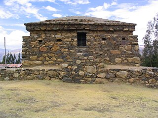
Wilcahuaín, Willcahuaín, or Huilcahuaín is an archaeological site in Peru. It is located near the village of Paria, 7 km northwest of the city of Huaraz, Ancash; at an elevation of 3,400 m (11,200 ft).

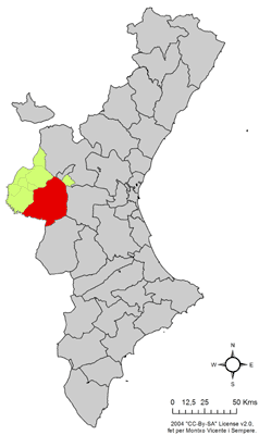
Los Isidros is a village in Valencia, Spain. It is part of the municipality of Requena.