Formation | 1970 |
---|---|
Headquarters | 19 Kuhn Road, Layton, New Jersey, United States |
Coordinates | 41°11′46″N74°51′04″W / 41.196047°N 74.851105°W |
Website | petersvalley |
Formerly called | Peters Valley Craftsmen |
Peters Valley School of Crafts (formerly the Peters Valley Craftsmen), is a nonprofit arts organization and craft school within the Delaware Water Gap National Recreation Area in Layton, New Jersey. [1] [2] It is located an hour and a half drive from New York City, [3] [4] and is part of the NRHP-listed Peters Valley Historic District. [5]
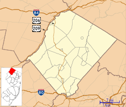
Peters Valley School of Crafts was incorporated in 1970 as a nonprofit dedicated to crafts, and was opened in 1971 as an experimental artist colony (or "living village") in the existing 18th and 19th century buildings. [1] [6] [7] [4] The headquarters is in the Victorian-style Doremus House.
They host the annual Peters Valley Craft Fair, to help support the school. [1] In 2020, the Peters Valley School of Crafts celebrated their 50th anniversary with a group art exhibition at the Hunterdon Art Museum in Clinton, New Jersey. [1]
The school focuses on education (non-degree) in blacksmithing, ceramics, surface design, fiber arts and weaving, light metals, photography, woodworking and glassmaking. [3] They offer workshops, youth classes, and artist residencies. The campus contains art studios, dormitories, a dining hall, offices, and a gallery. [8]
The Delaware River is a major river in the Mid-Atlantic region of the United States and is the longest free-flowing (undammed) river in the Eastern United States. From the meeting of its branches in Hancock, New York, the river flows for 282 miles (454 km) along the borders of New York, Pennsylvania, New Jersey, and Delaware, before emptying into Delaware Bay.
Solebury Township is a township in Bucks County, Pennsylvania, United States. The population was 8,709 at the 2020 census.
Delaware Water Gap is a water gap on the border of the U.S. states of New Jersey and Pennsylvania where the Delaware River cuts through a large ridge of the Appalachian Mountains.
A 1950s proposal to construct a dam near Tocks Island across the Delaware River was met with considerable controversy and protest. Tocks Island is located in the Delaware River a short distance north from the Delaware Water Gap. In order to control damaging flooding and provide clean water to supply New York City and Philadelphia, the U.S. Army Corps of Engineers proposed building a dam. When completed, the Tocks Island Dam would have created a 37-mile (60-km) long lake between Pennsylvania and New Jersey, with depths of up to 140 feet. This lake and the land surrounding were to be organized as the Tocks Island National Recreation Area. Although the dam was never built, 72,000 acres (291 km²) of land were acquired by condemnation and eminent domain. This incited environmental protesters and embittered local residents displaced by the project's preparations when their property was condemned. After the Tocks Island Dam project was withdrawn, the lands acquired were transferred to the oversight of the National Park Service which reorganized them to establish the Delaware Water Gap National Recreation Area.
The Dingman's Ferry Bridge is a toll bridge across the Delaware River between Delaware Township, Pennsylvania and Sandyston Township, New Jersey. Owned and operated by the Dingmans Choice and Delaware Bridge Company, it is the last privately-owned toll bridge on the Delaware and one of the few remaining in the United States. It is also the only bridge on the Delaware to toll traffic entering New Jersey.
Blue Mountain, Blue Mountain Ridge, or the Blue Mountains of Pennsylvania is a ridge of the Appalachian Mountains in eastern Pennsylvania. Forming the southern and eastern edge of the Ridge-and-Valley Appalachians physiographic province in Pennsylvania, Blue Mountain extends 150 miles (240 km) from the Delaware Water Gap on the New Jersey border in the east to Big Gap in Franklin County in south-central Pennsylvania at its southwestern end.
Delaware Water Gap National Recreation Area is a 70,000-acre (28,000 ha) national recreation area administered by the National Park Service in northwest New Jersey and northeast Pennsylvania. It is centered around a 40-mile (64 km) stretch of the Delaware River designated the Middle Delaware National Scenic River. At the area's southern end lays the Delaware Water Gap, a dramatic mountain pass where the river cuts between Blue Mountain and Kittatinny Mountain.
Old Mine Road is a road in New Jersey and New York said to be one of the oldest continuously used roads in the United States of America. At a length of 104 miles (167 km), it stretches from the Delaware Water Gap National Recreation Area to the vicinity of Kingston, New York.
Interstate 80 (I-80) is a major Interstate Highway in the United States, running from San Francisco, California, eastward to the New York metropolitan area. In New Jersey, I-80 runs for 68.35 miles (110.00 km) from the Delaware Water Gap Toll Bridge at the Pennsylvania state line to its eastern terminus at I-95 in Teaneck, Bergen County. I-95 continues from the end of I-80 to the George Washington Bridge for access to New York City. The highway runs parallel to U.S. Route 46 (US 46) through rural areas of Warren and Sussex counties before heading into more suburban surroundings in Morris County. As the road continues into Passaic and Bergen counties, it heads into more urban areas. The New Jersey Department of Transportation (NJDOT) identifies I-80 within the state as the Christopher Columbus Highway.
County Route 560 is a county highway in the U.S. state of New Jersey. The highway extends 5.05 miles (8.13 km) from U.S. Route 206 and County Route 521 in Sandyston Township. CR 560 ends at the Pennsylvania state line, where it becomes Pike County Quadrant Route 2019, which connects to Pennsylvania Route 739. CR 560's entire length is in Sandyston. However, CR 560 does pass through the hamlet of Layton.
Pahaquarry Township was a township that was located in Warren County, New Jersey, United States, from 1824 until it was dissolved in 1997.
The Skylands Region is a region of New Jersey located in the northern and central parts of the state. It is one of six tourism regions established by the New Jersey State Department of Tourism; the others are Gateway Region, Greater Atlantic City Region, the Southern Shore Region, the Delaware River Region, and the Shore Region.
The Waterfront Alliance or Metropolitan Waterfront Alliance (MWA) is a nonprofit organization that works to influence the development and use of the waterfront, shoreline, and connected upland areas of the Port of New York and New Jersey in northern New Jersey and New York City as well as other areas of the New York–New Jersey Harbor Estuary.
The Pahaquarry Copper Mine is an abandoned copper mine located on the west side of Kittatinny Mountain presently in Hardwick Township in Warren County, New Jersey in the United States. Active mining was attempted for brief periods during the mid-eighteenth, mid-nineteenth, and early twentieth centuries but was never successful despite developments in mining technology and improving mineral extraction methods. Such ventures were not profitable as the ore extracted proved to be of too low a concentration of copper. This site incorporates the mining ruins, hiking trails, and nearby waterfalls, and is located within the Delaware Water Gap National Recreation Area and administered by the National Park Service. It was added to the National Register of Historic Places in 1980 as a contributing property to the Old Mine Road Historic District.
The Minisink or Minisink Valley is a loosely defined geographic region of the Upper Delaware River valley in northwestern New Jersey, northeastern Pennsylvania and New York.
Van Campen's Inn or Isaac Van Campen Inn is a fieldstone residence that was used as a yaugh house during the American colonial era. Located in Walpack Township, Sussex County, New Jersey along the Delaware River, it is a historic site located along the Old Mine Road in the Delaware Water Gap National Recreation Area. It is operated under a memorandum of understanding between the National Park Service and the Walpack Historical Society, a local non-profit corporation.
Wallpack Ridge is a mountain located in the Ridge and Valley Appalachians physiographic province in Sussex County in northwestern New Jersey. Oriented northeast to southwest, Wallpack Ridge spans 25 miles (40 km) from Montague Township south of Port Jervis, New York to the Walpack Bend in the Delaware River near Flatbrookville in Walpack Township. It is a narrow ridge ranging between 0.67 miles (1.08 km) to 1.7 miles (2.7 km) in width, and its highest elevation reaches 928 feet (283 m) above sea level. The ridge separates the Wallpack Valley from the valley of the Delaware River, and contains the watershed of the Flat Brook and its main tributaries Big Flat Brook and Little Flat Brook.
Wallpack Valley is a valley located in Sussex County in northwestern New Jersey formed by Wallpack Ridge on the west, and Kittatinny Mountain on the east. Wallpack Ridge separates the Wallpack Valley from the valley of the Delaware River, and contains the watershed of the Flat Brook and its main tributaries Big Flat Brook and Little Flat Brook. It is a narrow valley, roughly 25 miles (40 km) in length running from Montague Township south of Port Jervis, New York to the Walpack Bend in the Delaware River near Flatbrookville in Walpack Township where the Flat Brook enters the Delaware at 300 feet above sea level.
Wallpack Center is an unincorporated community located within Walpack Township, Sussex County, in the U.S. state of New Jersey. Wallpack Center is located in the Flat Brook Valley 6.7 miles (10.8 km) west of Branchville. Wallpack Center has a post office with ZIP Code 07881. It is now part of the Delaware Water Gap National Recreation Area.
Bevans, also known as Peters Valley, is an unincorporated community located at the intersection of Bevans Road, Walpack Road, and Kuhn Road in Sandyston Township of Sussex County, New Jersey. The village is now part of the Delaware Water Gap National Recreation Area. Both the Delaware River and the Old Mine Road are nearby.