Petit Encantat | |
---|---|
Highest point | |
Elevation | 2,734 m (8,970 ft) |
Geography | |
Location | Catalonia, Spain |
Parent range | Pyrenees |
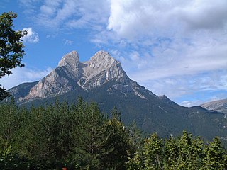
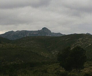
El Petit Encantat is a mountain peak of Catalonia, Spain. Located in the Pyrenees, it is the lower of the two peaks (the other being the Gran Encantat) of the Els Encantats mountain, with an altitude of 2,734 metres above sea level. [1]
Catalonia is an autonomous community in Spain on the northeastern corner of the Iberian Peninsula, designated as a nationality by its Statute of Autonomy. Catalonia consists of four provinces: Barcelona, Girona, Lleida, and Tarragona. The capital and largest city is Barcelona, the second-most populated municipality in Spain and the core of the sixth most populous urban area in the European Union. It comprises most of the territory of the former Principality of Catalonia. It is bordered by France (Occitanie) and Andorra to the north, the Mediterranean Sea to the east, and the Spanish autonomous communities of Aragon to the west and Valencia to the south. The official languages are Catalan, Spanish, and the Aranese dialect of Occitan.
Spain, officially the Kingdom of Spain, is a country mostly located in Europe. Its continental European territory is situated on the Iberian Peninsula. Its territory also includes two archipelagoes: the Canary Islands off the coast of Africa, and the Balearic Islands in the Mediterranean Sea. The African enclaves of Ceuta, Melilla, and Peñón de Vélez de la Gomera make Spain the only European country to have a physical border with an African country (Morocco). Several small islands in the Alboran Sea are also part of Spanish territory. The country's mainland is bordered to the south and east by the Mediterranean Sea except for a small land boundary with Gibraltar; to the north and northeast by France, Andorra, and the Bay of Biscay; and to the west and northwest by Portugal and the Atlantic Ocean.
The Pyrenees is a range of mountains in southwest Europe that forms a natural border between Spain and France. Reaching a height of 3,404 metres (11,168 ft) altitude at the peak of Aneto, the range separates the Iberian Peninsula from the rest of continental Europe, and extends for about 491 km (305 mi) from the Bay of Biscay to the Mediterranean Sea.
The Volta a Catalunya is a road bicycle race held annually in Catalonia, Spain.
Pica d'Estats is a 3,143-metre-high (10,312 ft) mountain in the Montcalm Massif, Pyrenees. on the Spanish–French border, and is the highest mountain in Catalonia.
Sant Jaume de Frontanyà is a municipality in the comarca of the Berguedà in Catalonia, Spain. It is situated in the Pyrenees below the peak of Pedró de Tubau (1543 m). The village was the smallest municipality in Catalonia in terms of population but in 2018 lost the title to Gisclareny after the village grew. The monumental Romanesque church of Sant Jaume is a protected historic-artistic monument from the 11th century. The village is served by a local road to Borredà and it is well known for its peace and tranquility.
Pedraforca is a mountain in the Pre-Pyrenees, located in the comarca of Berguedà. The mountain's rare form, along with the fact that it is not visibly connected to any other adjacent mountains or ridges, has made it one of the most famous and emblematic mountains in Catalonia.
Punta Gabarró or Punta de Gabarró is a mountain of the Montcalm Massif. Located in the Pyrenees, at the border between France and Spain, it has an elevation of 3,105 metres (10,187 ft) above sea level.
Pic de Finestrelles is a mountain located in the Oriental Pyrenees, in the area bordering the states of France and Spain, in concret in Catalonia. It has an altitude of 2,826 metres (9,272 ft) above sea level.
Gran Encantat is a mountain peak of Catalonia, Spain. Located in the Pyrenees, it is the higher of the two peaks of the Els Encantats mountain, with an altitude of 2,748 metres (9,016 ft) above sea level.
Turó de l'Home is a mountain of Catalonia, part of the Montseny Massif. With its elevation of 1,712 m (5,617 ft) above sea level, it is the highest peak of the Montseny Massif.
Tossal dels Tres Reis or Tossal del Rei is a mountain of the Ports de Tortosa-Beseit massif, Spain. It has an elevation of 1,350 metres above sea level.
La Mussara is a mountain of Catalonia, Spain. It is the highest peak of the Serra de la Mussara, a subrange of the Prades Mountains. Located north of the town of Vilaplana, La Mussara has an elevation of 1055 metres above sea level.
The Molacima is a mountain of the Serra del Montsià range, Catalonia, Spain. It has an elevation of 748 metres above sea level.
Serra de Montsant is a mountain chain in Catalonia, Spain. The main populated area in the range is La Morera de Montsant.
Muntanya de Santa Bàrbara is a mountain that is part of the northwestern foothills of the Ports de Tortosa-Beseit, Catalonia, Spain. It has an elevation of 751.3 metres above sea level.
Sant Llorenç del Munt is a largely rocky mountain massif in central Catalonia, Spain. The highest summit, where the Monestir de Sant Llorenç del Munt is located, has an elevation of 1,104.2 metres (3,623 ft) above sea level and is known as La Mola. Montcau 1,056.8 metres (3,467 ft) is another important peak of the massif. On the massif, there is a protected area under the name Parc Natural de Sant Llorenç del Munt i l'Obac.
The Albera Massif is a mountain range located in the south of Pyrénées-Orientales and the north of Catalonia, between France and Spain. It is the main easternmost prolongation of the Pyrenees. Its highest peak is the Puig Neulós, with an elevation of 1,256 metres.
Prades Mountains, also known as Muntanyes de Prades, is a large calcareous mountain massif straddling the comarcas of Alt Camp, Baix Camp, Conca de Barberà, Garrigues and Priorat, in Catalonia, Spain. They are a Site of Community Importance.
Buinaca or Punta de la Buinaca, also spelt Boinaca, is one of the highest mountains of the Cardó Massif, Catalan Pre-Coastal Range, Catalonia, Spain. This mountain has an elevation of 764 metres above sea level.
Serra de Llaberia is a mountain chain in Catalonia, Spain located between the Prades and the Tivissa-Vandellòs Mountains.
Serra de la Mussara is a mountain range of Catalonia, Spain. It is a subrange of the Prades Mountains. Located north of the town of Vilaplana, Its highest point La Mussara has an elevation of 1,055.6 metres (3,463 ft) above sea level; other important peaks are Punta del Sec, Tossal Rodó and La Puntota.
![]() | This article about a location in Catalonia is a stub. You can help Wikipedia by expanding it. |