
Landscape Arch is the longest of the many natural rock arches located in Arches National Park, Utah, United States.
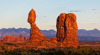
Balanced Rock is one of the most popular features of Arches National Park, situated in Grand County, Utah, United States. Balanced Rock is located next to the park's main road, at about 9.2 miles (14.8 km) from the park entrance. It is one of only a few prominent features clearly visible from the road.

The Entrada Sandstone is a formation in the San Rafael Group that is found in the U.S. states of Wyoming, Colorado, northwest New Mexico, northeast Arizona and southeast Utah. Part of the Colorado Plateau, this formation was deposited during the Jurassic period sometime between 180 and 140 million years ago in various environments, including tidal mudflats, beaches and sand dunes. The Middle Jurassic San Rafael Group was dominantly deposited as ergs in a desert environment around the shallow Sundance Sea.

Canyonlands National Park is an American national park located in southeastern Utah near the town of Moab. The park preserves a colorful landscape eroded into numerous canyons, mesas, and buttes by the Colorado River, the Green River, and their respective tributaries. Legislation creating the park was signed into law by President Lyndon Johnson on September 12, 1964.
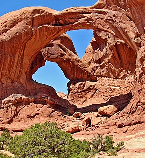
Double Arch is a close-set pair of natural arches in Arches National Park in southern Grand County, Utah, United States, that is one of the more known features of the park.

The exposed geology of the Canyonlands area is complex and diverse; 12 formations are exposed in Canyonlands National Park that range in age from Pennsylvanian to Cretaceous. The oldest and perhaps most interesting was created from evaporites deposited from evaporating seawater. Various fossil-rich limestones, sandstones, and shales were deposited by advancing and retreating warm shallow seas through much of the remaining Paleozoic.

The exposed geology of the Capitol Reef area presents a record of mostly Mesozoic-aged sedimentation in an area of North America in and around Capitol Reef National Park, on the Colorado Plateau in southeastern Utah.

Westwater Canyon is a canyon located on the Colorado River in Eastern Utah between the Utah/Colorado state line and Cisco, Utah. The inner gorge of the canyon is made up of black Precambrian rock and contains class III and IV rapids which are sought after by whitewater enthusiasts. The most notable rapid, called "Skull", is the most significant.

Snow Canyon State Park is a state park of Utah, USA, featuring a canyon carved from the red and white Navajo sandstone in the Red Mountains. The park is located near Ivins, Utah and St. George in Washington County. Other geological features of the state park include extinct cinder cones, lava tubes, lava flows, and sand dunes.

The Chinle Formation is an Upper Triassic continental geologic formation of fluvial, lacustrine, and palustrine to eolian deposits spread across the U.S. states of Nevada, Utah, northern Arizona, western New Mexico, and western Colorado. The Chinle is controversially considered to be synonymous to the Dockum Group of eastern Colorado and New Mexico, western Texas, the Oklahoma panhandle, and southwestern Kansas. The Chinle is sometimes colloquially named as a formation within the Dockum Group in New Mexico and in Texas. The Chinle Formation is part of the Colorado Plateau, Basin and Range, and the southern section of the Interior Plains.
Wilson Arch, also known as Wilson's Arch, is a natural sandstone arch in 38°16′22″N109°22′16″W, southeastern Utah, United States just off U.S. Route 191 located in San Juan County, 24 miles (39 km) south of Moab. It has a span of 91 feet (28 m) and height of 46 feet (14 m). It is visible from the road to the east where there are turnouts with interpretive signs. The elevation of Wilson Arch is about 6,150 feet (1,870 m).
Devils Garden is an area of Arches National Park, located near Moab, Utah, United States, that features a series of rock fins and arches formed by erosion. The Devils Garden Trail, including more primitive sections and spurs, meanders through the area for 7.2 mi (11.6 km). The trailhead leads directly to Landscape Arch after a 0.8 mi (1.3 km) outbound hike, while Tunnel Arch and Pine Tree Arch can be seen on spur trails on the way to Landscape Arch. Several other arches, including Partition, Navajo, Double O, and Private Arch, as well as the Dark Angel monolith and Fin Canyon, are accessed via the primitive loop trail and its spurs.

The Athabasca Sand Dunes Provincial Park was created to protect the Athabasca sand dunes, a unique geophysical land feature in the boreal shield ecosystem of the province of Saskatchewan. The Athabasca Sand Dunes are one of the most northerly active sand dune formations on Earth.

Wall Arch was a natural sandstone arch in Arches National Park in southeastern Utah, United States. Before its collapse in 2008, it was ranked 12th in size among the park's over 2,000 arches. At its largest, the opening underneath the span was 71 feet (22 m) wide by 33.5 feet (10 m) high. It consisted of Entrada Sandstone, specifically the member known as Slick Rock. Wall Arch was first reported and named in 1948 by Lewis T. McKinney.

The Fiery Furnace is a collection of narrow sandstone canyons, fins and natural arches in Arches National Park in Utah, USA.
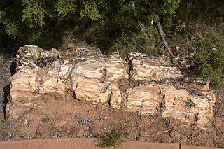
Escalante Petrified Forest State Park is a state park of Utah, USA, located a half-mile (0.8 km) north of the town of Escalante. A visitor center was built in 1991, and features displays of plant and marine fossils, petrified wood and fossilized dinosaur bones over 150 million years old. The Petrified Forest Trail is a one-mile (1.6 km) loop, winding up the side of a mesa to the top where most of the fossil wood occurs. Logs two feet or more in diameter are seen at several places along the trail where it is eroding from the conglomerate capping the mesa. This conglomerate lies near the top of the Brushy Basin Member of the Morrison Formation. The wood is multicolored and was prized by hobbyists before the Park was established. The logs are believed to be of conifers that were transported by a river before being buried and later fossilized as agate. A 50 foot (15m) log is displayed near the trail head and is one of the most complete fossil logs known from the Morrison Formation.

Corona Arch is a natural sandstone arch near Moab, Utah in a side canyon of the Colorado River west of Moab in Grand County, Utah, United States. It can be accessed via a 1.5-mile (2.4 km) hiking trail from Utah State Route 279.
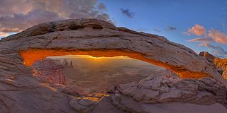
Mesa Arch is a pothole arch on the eastern edge of the Island in the Sky mesa in Canyonlands National Park in northern San Juan County, Utah, United States. It is featured as one of the standard desktop backgrounds on Windows 7 in the Landscapes section.
The Phallus is a rock formation (pillar) in Grand County, Utah, in the United States. It is within the Arches National Park.


