In the First Battle of Zurich on 4 – 7 June 1799, French general André Masséna was forced to yield the city to the Austrians under Archduke Charles and retreat beyond the Limmat, where he managed to fortify his positions, resulting in a stalemate.

Büren District was a district in the canton of Bern in Switzerland, with its capital at Büren an der Aare. It contained 14 municipalities in an area of 88 km²:

Moutier District was one of the three French-speaking districts of the Bernese Jura in the canton of Bern with the seat being Moutier, the other two being Courtelary and La Neuveville. It had a population of about 23,098 in 2004. The three districts were merged on 1 January 2010 to form the new district of Jura Bernois with the capital at Courtelary.
The Lytton First Nation, a First Nations government, has its headquarters at Lytton in the Fraser Canyon region of the Canadian province of British Columbia. While it is the largest of all Nlaka'pamux bands, unlike all other governments of the Nlaka'pamux (Thompson) people, it is not a member of any of the three Nlaka'pamux tribal councils, which are the Nicola Tribal Association, the Fraser Canyon Indian Administration and the Nlaka'pamux Nation Tribal Council.
Autukia is a settlement in Kiribati it had a population of 112 in the 2010 census. It is located on Nonouti atoll; to its north are Abamakoro, Benuaroa, Teuabu, Temanoku and Rotuma, while Matang(the administrative centre), Taboiaki and Temotu are to the south.

Qaraçaylı is a village in the Davachi Rayon of Azerbaijan. The village forms part of the municipality of Təzəkənd.
Bəyli is a village in the Qabala Rayon of Azerbaijan.
Linów-Leśniczówka is a settlement in the administrative district of Gmina Zwoleń, within Zwoleń County, Masovian Voivodeship, in east-central Poland.
Triantafyllia is a village and a community in Visaltia municipality, Serres regional unit, Central Macedonia, Greece. The population was 1,124 in 1981, but had dropped to 702 by 2011.

Wojny is a village in the administrative district of Gmina Biała Piska, within Pisz County, Warmian-Masurian Voivodeship, in northern Poland. It lies approximately 8 kilometres (5 mi) east of Biała Piska, 26 km (16 mi) east of Pisz, and 113 km (70 mi) east of the regional capital Olsztyn.
Moryń-Dwór is a settlement in the administrative district of Gmina Moryń, within Gryfino County, West Pomeranian Voivodeship, in north-western Poland.
Ruby Creek 2, normally referred to as Ruby Creek Indian Reserve No. 2, is an Indian Reserve in the Upper Fraser Valley region of British Columbia, Canada, located at the mouth of Ruby Creek at the northeast end of the District of Kent, near the locality of the same name, which is a part of Kent. The reserve is 16.6 hectares in size, and is under the jurisdiction of the Skawahlook First Nation, a member government of the Sto:lo Nation tribal council.

The Glatt Valley is a region and a river valley in the canton of Zürich in Switzerland.
Václavice is a municipality and village in Benešov District in the Central Bohemian Region of the Czech Republic.
Kitselas First Nation is the band government of the Kitselas subgroup of the Tsimshian. The band government is based at Gitaus in the Skeena Valley in the Skeena River valley to the northeast of the city of Terrace, British Columbia, Canada. Though there is no Tsimshian tribal council, they are a participant in the Tsimshian First Nations treaty council.
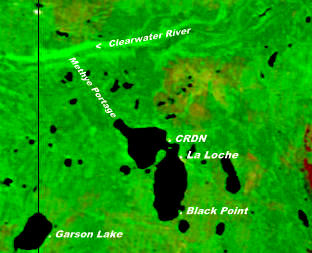
Black Point is a northern hamlet in Saskatchewan situated on the southern shore of Lac La Loche close to the northern village of La Loche. It is accessible by road by Highway 956 which is off Highway 155.
Kleine Höfats is a mountain of Bavaria, Germany.

Division No. 1, Subdivision E is an unorganized subdivision on the Avalon Peninsula in Newfoundland and Labrador, Canada. It is in Division 1 and contains the unincorporated communities of Broad Cove, Dildo, Green's Harbour, Harnum Point, Hopeall, New Harbour and Reids Room.
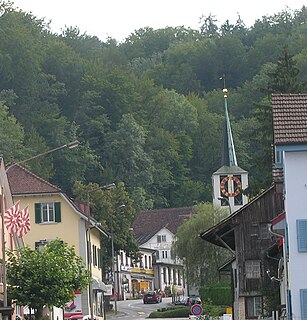
Öschbrig with an elevation of 696 metres (2,283 ft), is a wooded mountain in Switzerland overlooking to the east Zürichsee.