
A battle is an occurrence of combat in warfare between opposing military units of any number or size. A war usually consists of multiple battles. In general, a battle is a military engagement that is well defined in duration, area, and force commitment. An engagement with only limited commitment between the forces and without decisive results is sometimes called a skirmish.

A front line in military terminology is the position(s) closest to the area of conflict of an armed force's personnel and equipment, usually referring to land forces. When a front between opposing sides forms, the front line is the area where each side's forces are engaged in conflict. Leaders have often fought at the front lines either purposefully or due to a collapse in battle formation. While a calculated risk, fighting on the front has in instances reduced communication and heightened morale.

The geographic coordinate system (GCS) is a spherical or ellipsoidal coordinate system for measuring and communicating positions directly on the Earth as latitude and longitude. It is the simplest, oldest and most widely used of the thousands of spatial reference systems that are in use, and forms the basis for most others. Although latitude and longitude form a coordinate tuple like a cartesian coordinate system, the geographic coordinate system is not cartesian because the measurements are angles and are not on a planar surface.
Military strategy is a set of ideas implemented by military organizations to pursue desired strategic goals. Derived from the Greek word strategos, the term strategy, when it appeared in use during the 18th century, was seen in its narrow sense as the "art of the general", or "'the art of arrangement" of troops. Military strategy deals with the planning and conduct of campaigns, the movement and disposition of forces, and the deception of the enemy.

A multiple-unit train or simply multiple unit (MU) is a self-propelled train composed of one or more carriages joined together, which when coupled to another multiple unit can be controlled by a single driver, with multiple-unit train control.

The Continental Army was the army of the Thirteen Colonies and the Revolutionary-era United States. It was formed by the Second Continental Congress after the outbreak of the American Revolutionary War, and was established by a resolution of Congress on June 14, 1775. The Continental Army was created to coordinate military efforts of the Colonies in their war for independence. General George Washington was the commander-in-chief of the army throughout the war.
An invasion is a military offensive in which large numbers of combatants of one geopolitical entity aggressively enter territory owned by another such entity, generally with the objective of either conquering; liberating or re-establishing control or authority over a territory; forcing the partition of a country; altering the established government or gaining concessions from said government; or a combination thereof. An invasion can be the cause of a war, be a part of a larger strategy to end a war, or it can constitute an entire war in itself. Due to the large scale of the operations associated with invasions, they are usually strategic in planning and execution.

In the American Revolutionary War units of the Continental Army were assigned to any one of seven regional or territorial departments to decentralize their command and administration. This was necessary because the regiment was the largest permanent unit in the Continental Army. A superior headquarters, above regiment, was needed if more than a few regiments were stationed in the same department. Although brigades, divisions, and field armies existed, they were temporary units which did not necessarily include all the units assigned to a department. Nor did field armies include establishments of the staff, such as magazines of the Quartermaster General's Department, or hospitals of the Hospital Department. The militia in a department was usually at the disposal of the department commander.

Stapleton International Airport was a major airport in the western United States, the primary airport of Denver, Colorado, from 1929 to 1995.
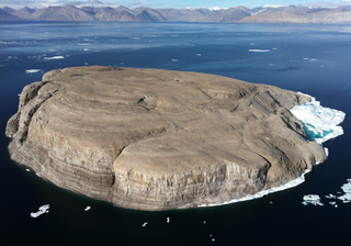
Hans Island is a barren uninhabited island measuring 1.3 km2 (0.5 sq mi), 1,290 m (4,230 ft) long and 1,199 m (3,934 ft) wide, in the centre of the Kennedy Channel of Nares Strait—the strait that separates Ellesmere Island from northern Greenland and connects Baffin Bay with the Lincoln Sea. Hans Island is the smallest of three islands in Kennedy Channel off the Washington Land coast; the others are Franklin Island and Crozier Island. The strait at this point is 35 km (22 mi) wide, placing the island within the territorial waters of both Canada and Greenland (Denmark). A theoretical line in the middle of the strait goes through the island.

The Distant Early Warning Line, also known as the DEW Line or Early Warning Line, was a system of radar stations in the northern Arctic region of Canada, with additional stations along the north coast and Aleutian Islands of Alaska, in addition to the Faroe Islands, Greenland, and Iceland. It was set up to detect incoming bombers of the Soviet Union during the Cold War, and provide early warning of any sea-and-land invasion.

An overhead power line is a structure used in electric power transmission and distribution to transmit electrical energy across large distances. It consists of one or more uninsulated electrical cables suspended by towers or poles.

The SEPTA Regional Rail system is a commuter rail network owned by the Southeastern Pennsylvania Transportation Authority and serving the Philadelphia Metropolitan area. The system has 13 branches and more than 150 active stations in Philadelphia, Pennsylvania, its suburbs and satellite towns and cities. It is the fifth-busiest commuter railroad in the United States, and the busiest outside of the New York and Chicago metropolitan areas. In 2016, the Regional Rail system had an average of 132,000 daily riders.

The Budapest Metro is the rapid transit system in the Hungarian capital Budapest. It is the oldest electrified underground railway system in continental Europe, and is only pre-dated by the London Underground. Budapest's iconic Line 1 was completed in 1896.
The Ligne à Grande Vitesse Est européenne, typically shortened to LGV Est, is a French high-speed rail line that connects Vaires-sur-Marne and Vendenheim. The line halved the travel time between Paris and Strasbourg and provides fast services between Paris and the principal cities of Eastern France as well as Luxembourg, Germany and Switzerland. The LGV Est is a segment of the Main Line for Europe project to connect Paris with Budapest with high-speed rail service.

The history of rapid transit began in London with the opening of the Metropolitan Railway, which is now part of the London Underground, in 1863. By World War I, electric underground railways were being used in Athens, Berlin, Boston, Buenos Aires, Budapest, Glasgow, Hamburg, Istanbul, Liverpool, New York City, Paris, and Philadelphia.
Simulation software is based on the process of modeling a real phenomenon with a set of mathematical formulas. It is, essentially, a program that allows the user to observe an operation through simulation without actually performing that operation. Simulation software is used widely to design equipment so that the final product will be as close to design specs as possible without expensive in process modification. Simulation software with real-time response is often used in gaming, but it also has important industrial applications. When the penalty for improper operation is costly, such as airplane pilots, nuclear power plant operators, or chemical plant operators, a mock up of the actual control panel is connected to a real-time simulation of the physical response, giving valuable training experience without fear of a disastrous outcome.
A military reserve, active reserve, reserve formation, or simply reserve, is a group of military personnel or units that is initially not committed to a battle by its commander, so that it remains available to address unforeseen situations or exploit sudden opportunities. Such a force may be held back to defend against attack from other enemy forces, to be committed to the existing battle if the enemy exposes a vulnerability, or to serve as relief for troops already fighting. Some of the different categories of military reserves are: tactical reserve, operational reserve, and strategic reserve.

Underwater search and recovery is the process of locating and recovering underwater objects, often by divers, but also by the use of submersibles, remotely operated vehicles and electronic equipment on surface vessels.
Cartographic generalization, or map generalization, includes all changes in a map that are made when one derives a smaller-scale map from a larger-scale map or map data. It is a core part of cartographic design. Whether done manually by a cartographer or by a computer or set of algorithms, generalization seeks to abstract spatial information at a high level of detail to information that can be rendered on a map at a lower level of detail. For example, we might have the outlines of all of the thousands of buildings in a region, but we wish to make a map of the whole city no more than a few inches wide. Instead of throwing out the building information, or trying to render it all at once, we could generalize the data into some sort of outline of the urbanized area of the region.

