Przewięź is a village in the administrative district of Gmina Płaska, within Augustów County, Podlaskie Voivodeship, in north-eastern Poland, close to the border with Belarus. It lies approximately 11 kilometres (7 mi) west of Płaska, 9 km (6 mi) east of Augustów, and 84 km (52 mi) north of the regional capital Białystok.

Nowinnik is a village in the administrative district of Gmina Narew, within Hajnówka County, Podlaskie Voivodeship, in north-eastern Poland. It lies approximately 5 kilometres (3 mi) south of Narew, 16 km (10 mi) north of Hajnówka, and 36 km (22 mi) south-east of the regional capital Białystok.

Zabłocie is a village in the administrative district of Gmina Narew, within Hajnówka County, Podlaskie Voivodeship, in north-eastern Poland. It lies approximately 5 kilometres (3 mi) south of Narew, 16 km (10 mi) north of Hajnówka, and 36 km (22 mi) south-east of the regional capital Białystok.

Budy Żelazne is a village in the administrative district of Gmina Mały Płock, within Kolno County, Podlaskie Voivodeship, in north-eastern Poland. It lies approximately 13 kilometres (8 mi) south-east of Kolno and 78 km (48 mi) west of the regional capital Białystok.
Piasutno Żelazne is a village in the administrative district of Gmina Zbójna, within Łomża County, Podlaskie Voivodeship, in north-eastern Poland.
Żakowola Radzyńska is a village in the administrative district of Gmina Kąkolewnica Wschodnia, within Radzyń Podlaski County, Lublin Voivodeship, in eastern Poland.

Kąt is a village in the administrative district of Gmina Grębów, within Tarnobrzeg County, Subcarpathian Voivodeship, in south-eastern Poland. It lies approximately 1 kilometre (1 mi) north-east of Grębów, 14 km (9 mi) east of Tarnobrzeg, and 61 km (38 mi) north of the regional capital Rzeszów.

Szlachecka is a village in the administrative district of Gmina Grębów, within Tarnobrzeg County, Subcarpathian Voivodeship, in south-eastern Poland. It lies approximately 1 kilometre (1 mi) south of Grębów, 14 km (9 mi) east of Tarnobrzeg, and 60 km (37 mi) north of the regional capital Rzeszów.
Króle is a village in the administrative district of Gmina Wąsewo, within Ostrów Mazowiecka County, Masovian Voivodeship, in east-central Poland.
Milewo-Bylice is a village in the administrative district of Gmina Krasne, within Przasnysz County, Masovian Voivodeship, in east-central Poland.
Janków is a village in the administrative district of Gmina Żelazków, within Kalisz County, Greater Poland Voivodeship, in west-central Poland.
Lubniczka is a village in the administrative district of Gmina Okonek, within Złotów County, Greater Poland Voivodeship, in west-central Poland.

Bielsko is a village in the administrative district of Gmina Koczała, within Człuchów County, Pomeranian Voivodeship, in northern Poland. It lies approximately 6 kilometres (4 mi) south-east of Koczała, 30 km (19 mi) north-west of Człuchów, and 114 km (71 mi) south-west of the regional capital Gdańsk.

Podwilczyn is a village in the administrative district of Gmina Dębnica Kaszubska, within Słupsk County, Pomeranian Voivodeship, in northern Poland. It lies approximately 9 kilometres (6 mi) south of Dębnica Kaszubska, 21 km (13 mi) south-east of Słupsk, and 96 km (60 mi) west of the regional capital Gdańsk.

Jeziorno is a village in the administrative district of Gmina Dzierzgoń, within Sztum County, Pomeranian Voivodeship, in northern Poland. It lies approximately 5 kilometres (3 mi) north-west of Dzierzgoń, 18 km (11 mi) east of Sztum, and 64 km (40 mi) south-east of the regional capital Gdańsk.

Biała Leśniczówka is a settlement in the administrative district of Gmina Tolkmicko, within Elbląg County, Warmian-Masurian Voivodeship, in northern Poland. It lies approximately 4 kilometres (2 mi) south of Tolkmicko, 24 km (15 mi) north of Elbląg, and 86 km (53 mi) north-west of the regional capital Olsztyn.
Malinówka Mała is a village in the administrative district of Gmina Ełk, within Ełk County, Warmian-Masurian Voivodeship, in northern Poland.

Łazdoje is a village in the administrative district of Gmina Kętrzyn, within Kętrzyn County, Warmian-Masurian Voivodeship, in northern Poland. It lies approximately 12 kilometres (7 mi) south-west of Kętrzyn and 58 km (36 mi) north-east of the regional capital Olsztyn.
Morzewko is a settlement in the administrative district of Gmina Morąg, within Ostróda County, Warmian-Masurian Voivodeship, in northern Poland.

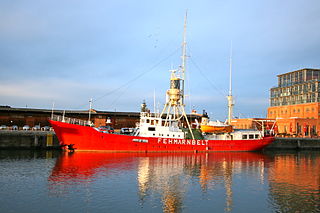
The Fehmarnbelt Lightship was built in 1906-1908 at Brake on the River Weser and entered service in 1908 as the lightship Außeneider. Until 1945 it was moored at the position known as Außeneider guarding the estuary of the river Eider on the North Sea coast. In the years from 1956 to 1965 it was a reserve lighthouse in the Baltic Sea and then from 1965 to 1984 it was positioned under its present name in the Fehmarn Belt.


