
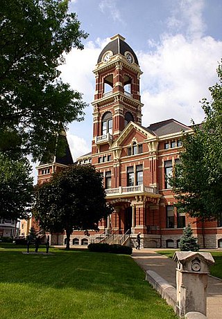
Kenton County is a county located in the northern part of the Commonwealth of Kentucky. As of the 2020 census, the population was 169,064, making it the third most populous county in Kentucky. Its county seats are Covington and Independence. It was, until November 24, 2010, the only county in Kentucky to have two legally recognized county seats. The county was formed in 1840 and is named for Simon Kenton, a frontiersman notable in the early history of the state.
Campbell County is a county located in the northern part of the U.S. state of Kentucky. As of the 2020 census, the population was 93,076. Its county seats are Alexandria and Newport. The county was formed on December 17, 1794, from sections of Scott, Harrison, and Mason Counties and was named for Colonel John Campbell (1735–1799), a Revolutionary War soldier and Kentucky legislator. Campbell County, with Boone and Kenton Counties, is part of the Northern Kentucky metro community, and the Cincinnati-Middletown, OH-KY-IN Metropolitan Statistical Area.

Boone County is a county located in the northern part of the U.S. state of Kentucky. As of the 2020 census, the population was 135,968, making it the fourth-most populous county in Kentucky. Its county seat is Burlington. The county was formed in 1798 from a portion of Campbell County. and was named for frontiersman Daniel Boone. Boone County, with Kenton and Campbell Counties, is of the Northern Kentucky metro area, and the Cincinnati-Middletown, OH-KY-IN Metropolitan Statistical Area. It is the location of the Cincinnati/Northern Kentucky International Airport, which serves Cincinnati and the tri-state area.

The City of Dayton, Kentucky, is a home rule-class city along a bend of the Ohio River in Campbell County, Kentucky, in the United States. The population was 5,338 at the 2010 census. It is less than 3 miles (5 km) from downtown Cincinnati, Ohio.

Maysville is a home rule-class city in Mason County, Kentucky, United States and is the seat of Mason County. The population was 8,782 as of 2019, making it the 51st-largest city in Kentucky by population. Maysville is on the Ohio River, 66 miles (106 km) northeast of Lexington. It is the principal city of the Maysville Micropolitan Statistical Area, which includes Mason and Lewis counties. Two bridges cross the Ohio from Maysville to Aberdeen, Ohio: the Simon Kenton Memorial Bridge built in 1931 and the William H. Harsha Bridge built in 2001.

Northern Kentucky is the third-largest metropolitan area in the United States Commonwealth of Kentucky after Louisville and Lexington, and its cities and towns serve as the de facto "south side" communities of Cincinnati, Ohio. The three main counties of this metro area are Boone, Kenton, and Campbell along the Ohio River, with other counties also included. The label "Northern Kentucky" is used to demonstrate the common identity shared across county and city lines by the residents of these northern counties. Arguably, the label seeks to reverse the divisions that occurred to Campbell County, which, in 1794, included the land of Boone, Kenton, Pendleton Counties, and most of Bracken and Grant Counties. The urban and suburban areas of the northern counties are densely populated. Indeed, of Greater Cincinnati's over two million residents, 450,994 of them live in Northern Kentucky (2019), with the three most northern counties contributing 394,163 residents themselves. The largest cities in each of the three most northern counties are Covington, Florence, and Fort Thomas.

U.S. Route 68 is a United States highway that runs for 560 miles (900 km) from northwest Ohio to Western Kentucky. The highway's western terminus is at US 62 in Reidland, Kentucky. Its present northern terminus is at Interstate 75 in Findlay, Ohio, though the route once extended as far north as Toledo. US 68 intersects with US 62 three times during its route.
Piatt is a surname. Notable people with the surname include:

Hebron is an unincorporated community and census-designated place (CDP) in Boone County, Kentucky, United States. The city is named after the biblical city of Hebron. As of the 2010 census, it had a population of 5,929. It is home to the Cincinnati/Northern Kentucky International Airport, which serves Cincinnati and the Tri-State (Ohio-Kentucky-Indiana) area.
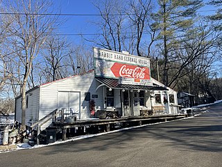
Rabbit Hash is an unincorporated community and census-designated place (CDP) in Boone County, Kentucky, United States, with a population of 315. It is listed on the National Register of Historic Places. The town is notable for its name, its string of canine mayors, and its historic general store which was largely destroyed by fire in 2016.
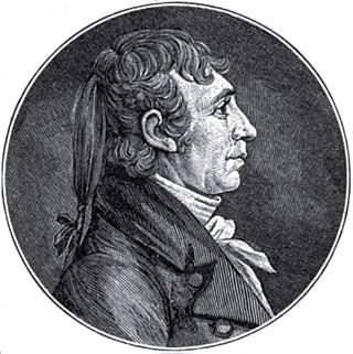
James Taylor V (1769–1848) was an American banker, Quartermaster general, and one of the wealthiest early settlers of Kentucky. He was a founder of the city of Newport, Kentucky.

The Licking River is a partly navigable, 303-mile-long (488 km) tributary of the Ohio River in northeastern Kentucky. The river and its tributaries drain much of the region of northeastern Kentucky between the watersheds of the Kentucky River to the west and the Big Sandy River to the east. The North Fork Licking River, in Pendleton County, Kentucky, is one of its tributaries. The South Fork Licking River, in counties including Harrison County, Kentucky, is another.

The Anderson Ferry is a ferry across the Ohio River between Cincinnati, Ohio and Constance, Kentucky. It has been in continuous operation since 1817. It was originated by George W Anderson the founder of the business, sold to the Kottmyer family then known as the Kotmeyer ferry and was later sold back to the Anderson family in 1986. The ferry was often used in the 19th century by Kentucky farmers bringing their product to market in Cincinnati. It is the lone survivor of dozens of ferries that once served the Cincinnati area. The ferry is located about 8 miles (13 km) west of Downtown Cincinnati.

East Bend is a region of Boone County, Kentucky, about 20 miles southwest of Cincinnati, Ohio. The region is well named; there the Ohio River makes an almost right angle turn, and flows east for ten miles or more. On the Kentucky side of the river, the land is mostly bottom land and good farm land. Points on interest are the river towns of Belleville, Mcville, Rabbit Hash, Piatt's Landing and Hamilton. There is a salt spring at Big Bone Lick where mastodon and buffalo bones have been found.

Riverside is a neighborhood in Cincinnati, Ohio. The West Side neighborhood is contained in a narrow strip of land along the Ohio River between Sayler Park and Sedamsville. It is a community that is more industrial than residential. It is home to St. Vincent De Paul Catholic Church. Riverside is also home to the Mount St. Joseph University ball fields.

Downtown Cincinnati is the central business district of Cincinnati, Ohio, as well the economic and symbiotic center of the Cincinnati metropolitan area. It also contains a number of urban neighborhoods in the low land area between the Ohio River and the high land areas of uptown. These neighborhoods include Over-the-Rhine, Pendleton, Queensgate, and West End.

Francisville is a census-designated place (CDP) in Boone County, Kentucky, United States. Its population was 7,944 as of the 2010 census. Francisville shares ZIP code 41048 with the neighboring CDP of Hebron. It is the northernmost community in the state.

The Cincinnati metropolitan area is a metropolitan area centered on Cincinnati and including surrounding counties in the U.S. states of Ohio, Kentucky, and Indiana. The area is commonly known as Greater Cincinnati.


