
The Arctic Archipelago, also known as the Canadian Arctic Archipelago, is an archipelago lying to the north of the Canadian continental mainland, excluding Greenland and Iceland.

The Leverett Glacier is about 50 nautical miles (90 km) long and 3 to 4 nautical miles wide, flowing from the Antarctic Plateau to the south end of the Ross Ice Shelf through the Queen Maud Mountains. It is an important part of the South Pole Traverse from McMurdo Station to the Admundson–Scott South Pole Station, providing a route for tractors to climb from the ice shelf through the Transantarctic Mountains to the polar plateau.
Tucker Glacier is a major valley glacier of Victoria Land, Antarctica, about 90 nautical miles long, flowing southeast between the Admiralty Mountains and the Victory Mountains to the Ross Sea. There is a snow saddle at the glacier's head, just west of Homerun Range, from which the Ebbe Glacier flows northwestward.

The Usarp Mountains are a major mountain range in North Victoria Land, Antarctica. They are west of the Rennick Glacier and trend north to south for about 190 kilometres (118 mi). The mountains are bounded to the north by Pryor Glacier and the Wilson Hills. They are west of the Bowers Mountains.
Borchgrevink Glacier is a large glacier in the Victory Mountains, Victoria Land, Antarctica. It drains south between Malta Plateau and Daniell Peninsula, and thence projects into Glacier Strait, Ross Sea, as a floating glacier tongue.
Zykov Glacier is a valley glacier about 25 nautical miles long in the Anare Mountains of Victoria Land, Antarctica. It flows northwest and reaches the coast between Cape Williams and Cooper Bluffs. It was photographed by the Soviet Antarctic Expedition (SovAE) in 1958 and named for student navigator Ye. Zykov, who died in Antarctica, Feb. 3, 1957.

Aagaard Glacier, also known as Glaciar Alderete, is an 8-mile (13 km) long Antarctic glacier which lies close to the east of Gould Glacier and flows in a southerly direction into Mill Inlet, on the east coast of Graham Land. It was charted by the Falkland Islands Dependencies Survey (FIDS) and photographed from the air by the Ronne Antarctic Research Expedition during December 1947; it was named by the FIDS for Bjarne Aagaard, a Norwegian authority on Antarctic whaling and exploration.

Timbiqui is a town and municipality in the Cauca Department, Colombia. An earthquake affected its inhabitants on the first of October, 2012.
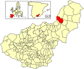
Cortes de Baza is a municipality located in the province of Granada, Spain. According to the Instituto de Estadistica y Cartografia de Andalucia (2020), the village has a population of 1844 inhabitants.

Aija is a town in central Peru, capital of the province Aija in the region Ancash, on the west side of the Cordillera Negra.
Achaean Range is a mountain range rising to 2,577 metres (8,455 ft) in the central part of Anvers Island in the Palmer Archipelago. It is bounded on the east by Iliad Glacier and Trojan Range and on the west by Marr Ice Piedmont, and extends northwest from Mount Agamemnon for 10 kilometres (6 mi), curving northeast for a further 19 km (12 mi) to Mount Nestor. Surveyed by the Falkland Islands Dependencies Survey (FIDS) in 1955 and named by the United Kingdom Antarctic Place-Names Committee (UK-APC) for the Achaeans, one of the opposing forces of the Trojan War in Homer's Iliad.
This is a list of the extreme points and extreme elevations in Scotland.
The Porthos Range is the second range south in the Prince Charles Mountains of Antarctica, extending for about 30 miles in an east-to-west direction between Scylla Glacier and Charybdis Glacier. First visited in December 1956 by the Australian National Antarctic Research Expeditions (ANARE) southern party under W.G. Bewsher (1956-57) and named after Porthos, a character in Alexandre Dumas, père's novel The Three Musketeers, the most popular book read on the southern journey.

Swift Glacier is a steep glacier about 2 nautical miles (3.7 km) long, close west of Jefford Point, James Ross Island. Named by United Kingdom Antarctic Place-Names Committee (UK-APC) following Falkland Islands Dependencies Survey (FIDS) surveys, 1958–61. The name is descriptive, this being one of the most active glaciers on the island.

Sjogren Glacier is a glacier 12.5 miles (20 km) long in the south part of Trinity Peninsula, flowing southeast from Detroit Plateau in between Aldomir Ridge and Hazarbasanov Ridge to enter Prince Gustav Channel at the head of Sjögren Inlet, west of Royak Point. Discovered in 1903 by the Swedish Antarctic Expedition under Nordenskjold. He named it Sjogren Fiord after a patron of the expedition. The true nature of the feature was determined by the Falkland Islands Dependencies Survey (FIDS) in 1945.
Renard Glacier is a glacier flowing into the southernmost part of Charlotte Bay, on the west coast of Graham Land. Charted by the Belgian Antarctic Expedition under Gerlache, 1897–99. Named by the United Kingdom Antarctic Place-Names Committee (UK-APC) in 1960 for Charles Renard (1847–1905), who, with A.C. Krebs, constructed and flew the first dirigible airship capable of steady flight under control, in 1884.

The Subprefecture of Campo Limpo is one of 32 subprefectures of the city of São Paulo, Brazil. It comprises three districts: Campo Limpo, Capão Redondo, and Vila Andrade. The slum of Paraisópolis, the second largest of the city and surrounded by middle-to-upper class apartment buildings, is located here.
The Rawson Mountains lie within the Queen Maud Mountains to the southeast of the Ross Ice Shelf in Antarctica. They are a crescent-shaped range of tabular, ice-covered mountains including Fuller Dome, Mount Wyatt and Mount Verlautz, standing southeast of Nilsen Plateau and extending southeast for 18 nautical miles to the west side of Scott Glacier.