Related Research Articles

A geographic information system (GIS) consists of integrated computer hardware and software that store, manage, analyze, edit, output, and visualize geographic data. Much of this often happens within a spatial database, however, this is not essential to meet the definition of a GIS. In a broader sense, one may consider such a system also to include human users and support staff, procedures and workflows, the body of knowledge of relevant concepts and methods, and institutional organizations.
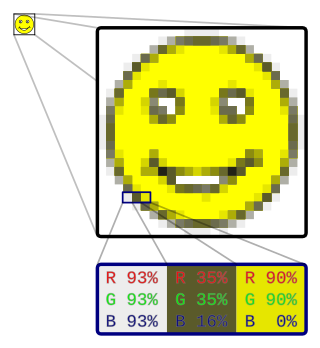
In computer graphics and digital photography, a raster graphic represents a two-dimensional picture as a rectangular matrix or grid of pixels, viewable via a computer display, paper, or other display medium. A raster is technically characterized by the width and height of the image in pixels and by the number of bits per pixel. Raster images are stored in image files with varying dissemination, production, generation, and acquisition formats.

Remote sensing is the acquisition of information about an object or phenomenon without making physical contact with the object, in contrast to in situ or on-site observation. The term is applied especially to acquiring information about Earth and other planets. Remote sensing is used in numerous fields, including geophysics, geography, land surveying and most Earth science disciplines. It also has military, intelligence, commercial, economic, planning, and humanitarian applications, among others.

Aerial photography is the taking of photographs from an aircraft or other airborne platforms. When taking motion pictures, it is also known as aerial videography.
Ground truth is information that is known to be real or true, provided by direct observation and measurement as opposed to information provided by inference.

Motion capture is the process of recording the movement of objects or people. It is used in military, entertainment, sports, medical applications, and for validation of computer vision and robots. In filmmaking and video game development, it refers to recording actions of human actors and using that information to animate digital character models in 2D or 3D computer animation. When it includes face and fingers or captures subtle expressions, it is often referred to as performance capture. In many fields, motion capture is sometimes called motion tracking, but in filmmaking and games, motion tracking usually refers more to match moving.

Photogrammetry is the science and technology of obtaining reliable information about physical objects and the environment through the process of recording, measuring and interpreting photographic images and patterns of electromagnetic radiant imagery and other phenomena.
An orthophoto, orthophotograph, orthoimage or orthoimagery is an aerial photograph or satellite imagery geometrically corrected ("orthorectified") such that the scale is uniform: the photo or image follows a given map projection. Unlike an uncorrected aerial photograph, an orthophoto can be used to measure true distances, because it is an accurate representation of the Earth's surface, having been adjusted for topographic relief, lens distortion, and camera tilt.

Satellite images are images of Earth collected by imaging satellites operated by governments and businesses around the world. Satellite imaging companies sell images by licensing them to governments and businesses such as Apple Maps and Google Maps.

A virtual globe is a three-dimensional (3D) software model or representation of Earth or another world. A virtual globe provides the user with the ability to freely move around in the virtual environment by changing the viewing angle and position. Compared to a conventional globe, virtual globes have the additional capability of representing many different views of the surface of Earth. These views may be of geographical features, man-made features such as roads and buildings, or abstract representations of demographic quantities such as population.
MrSID is an acronym that stands for multiresolution seamless image database. It is a file format developed and patented by LizardTech for encoding of georeferenced raster graphics, such as orthophotos.

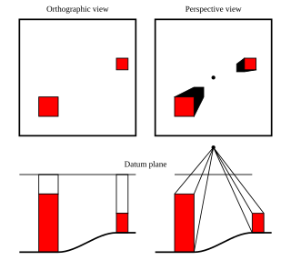
Pictometry International is an aerial measurement company based in Henrietta, New York that develops software that uses three-dimensional aerial photographs to view high-resolution images of buildings in their entirety. Pictometry International's technology was developed at the Rochester Institute of Technology and shows structures at an oblique angle or at a 45-degree angle, from all sides providing perspective and overhead shot images that are accurate to 1/100th of an inch. The company has 80 Cessnas that provide high-resolution aerial photography in counties that include 95 percent of the U.S. population.
Georeferencing or georegistration is a type of coordinate transformation that binds a digital raster image or vector database that represents a geographic space to a spatial reference system, thus locating the digital data in the real world. It is thus the geographic form of image registration. The term can refer to the mathematical formulas used to perform the transformation, the metadata stored alongside or within the image file to specify the transformation, or the process of manually or automatically aligning the image to the real world to create such metadata. The most common result is that the image can be visually and analytically integrated with other geographic data in geographic information systems and remote sensing software.

Terrain cartography or relief mapping is the depiction of the shape of the surface of the Earth on a map, using one or more of several techniques that have been developed. Terrain or relief is an essential aspect of physical geography, and as such its portrayal presents a central problem in cartographic design, and more recently geographic information systems and geovisualization.

Airborne Real-time Cueing Hyperspectral Enhanced Reconnaissance, also known by the acronym ARCHER, is an aerial imaging system that produces ground images far more detailed than plain sight or ordinary aerial photography can. It is the most sophisticated unclassified hyperspectral imaging system available, according to U.S. Government officials. ARCHER can automatically scan detailed imaging for a given signature of the object being sought, for abnormalities in the surrounding area, or for changes from previous recorded spectral signatures.

Aerial photographic and satellite image interpretation, or just image interpretation when in context, is the act of examining photographic images, particularly airborne and spaceborne, to identify objects and judging their significance. This is commonly used in military aerial reconnaissance, using photographs taken from reconnaissance aircraft and reconnaissance satellites.

Nearmap is an aerial technology company headquartered in Australia that provides frequently-updated, high-resolution aerial imagery and location intelligence on up to 95% of Australia's population, 80% of the United States population, 75% of the New Zealand population, and 66% of Canada's population. It was a publicly traded company on the Australian Securities Exchange until being taken private by Thoma Bravo in 2022.
Red Hen Systems, Inc. is a technology company that develops integrated hardware and software for multimedia asset mapping. Their spatial digital video recorders (DVRs) and still cameras instantly geotag video and still photos at the time of data collection. Corresponding mapping software provides the capability to view photographs, video, and audio using GPS coordinates.
An aerial image library is a collection of aerial imagery. The imagery is taken from cameras placed on aircraft, which capture images of the structures and features of the land below. These libraries can contain millions of individual images which depict geographic areas in incredible detail.

CATUAV S.L. is a technology-based private company that offers aerial services using unmanned aerial vehicles (UAV). Its headquarters are located in the Moià airfield in the BCN Drone Center, 40 km north of Barcelona, Spain.
References
- ↑ Metric Oblique Imagery
- ↑ GIS: Pictometry: Oblique Imagery training
- ↑ "Ims Integration Package" (PDF).
- ↑ "Pictometry: Potentials for Land Administration" (PDF).
- ↑ Pictometry - The Aerial Oblique Photography Company
- ↑ "Pictometry Viewer Application". gis.massdot.state.ma.us. Retrieved 2022-05-20.
- ↑ "Pima County Geographic Information Systems - About Pictometry Aerial Photos". gis.pima.gov. Retrieved 2022-05-20.
- ↑ Marion County, Kansas > Departments > Emergency Communications > What is Pictometry
- ↑ Web-based GIS and Digital Oblique Imagery - Journal of Property Assessment & Administration - by Lema Kebede -
- ↑ Pictometry | PVSC - Property Assessment Nova Scotia
- ↑ Provider Calls Pictometry® A Revolutionary Technology For The Pipeline Industry | Pipeline & Gas Journal
- ↑ Method and apparatus for capturing, geolocating and measuring oblique images - Pictometry International Corporation