This article needs additional citations for verification .(September 2015) |

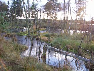
The Pietzmoor (literally "Pietz Bog") is a bog southeast of the town of Schneverdingen, Lower Saxony, Germany.
This article needs additional citations for verification .(September 2015) |
The Pietzmoor (literally "Pietz Bog") is a bog southeast of the town of Schneverdingen, Lower Saxony, Germany.
The Pietzmoor is the largest contiguous area of bog on the Lüneburg Heath. The bog lies southeast of the town of Schneverdingen and is bordered to the south by the village of Heber.
The Pietzmoor has an average peat depth of 4 m, its maximum thickness is 7.5 m. The bog is the source of the rivers Böhme and Veerse.
The bog is named after the little village of Pietz.
For centuries the bog provided the inhabitants of the surrounding villages with peat for fuel.
Today the Pietzmoor is a tourist destination in the Lüneburg Heath Nature Reserve with an area of 2.5 km2. Two board walks, 4.8 km and 6.6 km long, run right through the marshy terrain.
| Wikimedia Commons has media related to Pietzmoor . |
Coordinates: 53°05′42″N9°49′32″E / 53.09500°N 9.82556°E
| | This Heidekreis location article is a stub. You can help Wikipedia by expanding it. |

Heidekreis is a district (Landkreis) in Lower Saxony, Germany. It is bounded by the districts of Harburg, Lüneburg, Uelzen, Celle, Hanover, Nienburg, Verden and Rotenburg.
Gifhorn is a district in Lower Saxony, Germany.

Lüneburg Heath is a large area of heath, geest, and woodland in the northeastern part of the state of Lower Saxony in northern Germany. It forms part of the hinterland for the cities of Hamburg, Hanover and Bremen and is named after the town of Lüneburg. Most of the area is a nature reserve. Northern Low Saxon is still widely spoken in the region.

The Böhme is a right-bank, northeastern tributary of the Aller in the district of Soltau-Fallingbostel in the north German state of Lower Saxony. The river is 72 kilometres (45 mi) long.

Schneverdingen is a city in the northern part of the district of Heidekreis, in Lower Saxony, Germany. It is located in the area known as Lüneburg Heath.

Bispingen is a municipality in the Heidekreis district of Lower Saxony, Germany. It is a popular tourist destination with several holiday/theme parks. Its territory also includes the nature preserve of the Lüneburg Heath around the Wilseder Berg.

The North German Plain or Northern Lowland is one of the major geographical regions of Germany. It is the German part of the North European Plain. The region is bounded by the coasts of the North Sea and the Baltic Sea to the north, Germany's Central Uplands to the south, by the Netherlands to the west and Poland to the east.

The Lüneburg Heath Nature Reserve is one of the oldest and largest nature reserves in Germany, and the oldest and largest in Lower Saxony. It was first established on 29 December 1921 when an area of four square miles was declared a nature park by the Prussian government.

The Harburg Hills are a low ridge in the northeastern part of the German state of Lower Saxony and the southern part of the city state of Hamburg. They are up to 155 metres (509 ft) high.

The Bullenkuhle is a predominantly marshy lake in the extreme north of the district of Gifhorn in the north German state of Lower Saxony. This strange biotope and geotope has been formed into a natural hollow in the terrain that is termed a sinkhole. The area is environmentally protected.

The Südheide Nature Park is a large protected area of forest and heathland in the southern part of the Lüneburg Heath in North Germany. It has been designated as a protected nature park since 1964.

The Grundloses Moor is the largest, virtually intact raised bog in the district of Heidekreis and a nature reserve in Walsrode in the German state of Lower Saxony.
The Tiste Bauernmoor is an area of raised bog on the Lüneburg Heath in north Germany that was designated as a nature reserve on 2 May 2002. It has an area of 570 hectares and belongs, together with the Ekelmoor, Avensermoor and Everstofer Moor, to the large Ekelmoor moorland region that has a total area of 1,220 hectares.

The Großes Moor near Gifhorn is part of the Northwest German raised bog region, which stretches from the Netherlands to the eastern border of Lower Saxony on the sandy areas (geest) left behind by the ice age. The moor has a total area of about 6,100 hectares, of which around 5,000 hectares are raised bog and some 1,100 hectares are fen. The peat layer is up to almost 6 metres thick in places. Individual parts of the moor have their own names like Stüder Moor, Hestenmoor or Weißes Moor.

The Maujahn or Maujahn Moor is a kettle bog in North Germany which began as a sinkhole. It is located a good two kilometres west of the town of Dannenberg between the villages of Thunpadel and Schmarsau in northeastern Lower Saxony.

The Wümme Depression is a bog, geest and forest landscape within the Elbe–Weser triangle in the German state of Lower Saxony. It belongs mainly to the district of Rotenburg and is part of the Stade Geest. To the south it borders on the Achim-Verden Geest. It has no sharply defined boundary with the Lüneburg Heath; as a result many places are seen as belonging to both regions. Typical of the gently undulating terrain are the many small rivers, streams and lakes. These include the rivers Wümme, Wieste, Fintau, Rodau, Wiedau and Vissel, as well as the twin lakes known in German as the Bullenseen. In this ancient landscape Low German is commonly spoken.
Langeloh is a village within the town of Schneverdingen in the district of Soltau-Fallingbostel in the North German state of Lower Saxony. The village lies about 5 kilometres (3.1 mi) south of the town and is linked to it by the district roads (Kreisstrassen) K26 and K33. The parish is characterised by fields and moors with farm woodland and borders on the Pietzmoor.
Reinsehlen Camp is a largely treeless area of around 100 hectares close to the village of Reinsehlen near the town of Schneverdingen in Lower Saxony, Germany. It is known for its calcareous grassland and most of the area is now a nature reserve. In the past, the area served as a military airfield, a Displaced Persons camp and a military training area. From 1950 to 1994 the Canadian and British armed forces used the area as base camp for extensive tank exercises in the Lüneburg Heath — thus the name "Camp".
The Red Moor is a raised bog in the Hessian part of the Rhön Mountains in Germany. It lies within the eponymous nature reserve in the Rhön Biosphere Reserve and is part of the Europe-wide conservation system, Natura 2000. The Red Moor has an area of 50 hectares and is the second largest raised bog in the High Rhön after the Black Moor (66.4 hectares). For 175 years, until 1984, peat was cut here. The interior of the raised bog is severely damaged, especially as a result of the many years of peat cutting. Its perimeters are however still largely undisturbed areas that are better and more typically developed than the Black Moor, 8 kilometres away. In 1979 large-scale renaturalisation measures began.