
The Columbia River is the largest river in the Pacific Northwest region of North America. The river forms in the Rocky Mountains of British Columbia, Canada. It flows northwest and then south into the U.S. state of Washington, then turns west to form most of the border between Washington and the state of Oregon before emptying into the Pacific Ocean. The river is 1,243 mi (2,000 km) long, and its largest tributary is the Snake River. Its drainage basin is roughly the size of France and extends into seven states of the United States and one Canadian province. The fourth-largest river in the United States by flow, the Columbia has the greatest flow of any river into the eastern Pacific and the 36th greatest discharge of any river in the world.

The Snake River is a major river in the interior Pacific Northwest region of the United States. About 1,080 miles (1,740 km) long, it is the largest tributary of the Columbia River, which is the largest North American river that empties into the Pacific Ocean. Beginning in Yellowstone National Park, western Wyoming, it flows across the arid Snake River Plain of southern Idaho, the rugged Hells Canyon on the borders of Idaho, Oregon and Washington, and finally the rolling Palouse Hills of southeast Washington. It joins the Columbia River just downstream from the Tri-Cities, Washington, in the southern Columbia Basin.

The Willamette River is a major tributary of the Columbia River, accounting for 12 to 15 percent of the Columbia's flow. The Willamette's main stem is 187 miles (301 km) long, lying entirely in northwestern Oregon in the United States. Flowing northward between the Oregon Coast Range and the Cascade Range, the river and its tributaries form the Willamette Valley, a basin that contains two-thirds of Oregon's population, including the state capital, Salem, and the state's largest city, Portland, which surrounds the Willamette's mouth at the Columbia.

Ferry County is a county located on the northern border of the U.S. state of Washington. As of the 2020 census, the population was 7,178, making it the fourth-least populous county in Washington. The county seat and largest city is Republic. The county was created out of Stevens County in February 1899 and is named for Elisha P. Ferry, the state's first governor.
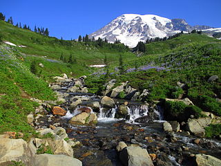
Mount Rainier National Park is a national park of the United States located in southeast Pierce County and northeast Lewis County in Washington state. The park was established on March 2, 1899, as the fourth national park in the United States, preserving 236,381 acres including all of Mount Rainier, a 14,410-foot (4,390 m) stratovolcano. The mountain rises abruptly from the surrounding land with elevations in the park ranging from 1,600 feet to over 14,000 feet (490–4,300 m). The highest point in the Cascade Range, Mount Rainier is surrounded by valleys, waterfalls, subalpine meadows, and 91,000 acres of old-growth forest. More than 25 glaciers descend the flanks of the volcano, which is often shrouded in clouds that dump enormous amounts of rain and snow.

Lake Washington is a large freshwater lake adjacent to the city of Seattle, Washington, United States. It is the largest lake in King County and the second largest natural lake in the state of Washington, after Lake Chelan. It borders the cities of Seattle on the west, Bellevue and Kirkland on the east, Renton on the south, and Kenmore on the north, and encloses Mercer Island. The lake is fed by the Sammamish River at its north end and the Cedar River at its south.

The Chehalis River is a river in Washington in the United States. It originates in several forks in southwestern Washington, flows east, then north, then west, in a large curve, before emptying into Grays Harbor, an estuary of the Pacific Ocean. The river is the largest solely contained drainage basin in the state.

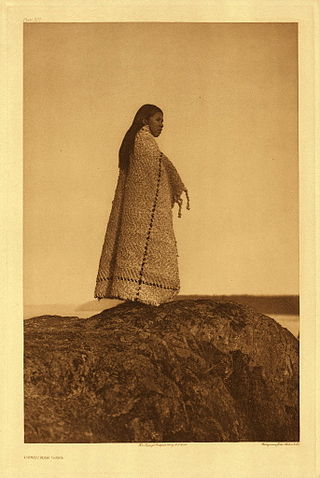
Chinookan peoples include several groups of Indigenous people of the Pacific Northwest in the United States who speak the Chinookan languages. Since at least 4000 BCE Chinookan peoples have resided along the upper and Middle Columbia River (Wimahl) from the river's gorge downstream (west) to the river's mouth, and along adjacent portions of the coasts, from Tillamook Head of present-day Oregon in the south, north to Willapa Bay in southwest Washington. In 1805 the Lewis and Clark Expedition encountered the Chinook Tribe on the lower Columbia.
The Trask River is in northwestern Oregon in the United States. It drains a mountainous timber-producing area of the Northern Oregon Coast Range west of Portland into Tillamook Bay and the Pacific Ocean. It is one of five rivers—the Tillamook, the Trask, the Wilson, the Kilchis, and the Miami—that flow into the bay.

The Columbia Basin Project in Central Washington, United States, is the irrigation network that the Grand Coulee Dam makes possible. It is the largest water reclamation project in the United States, supplying irrigation water to over 670,000 acres (2,700 km2) of the 1,100,000 acres (4,500 km2) large project area, all of which was originally intended to be supplied and is still classified irrigable and open for the possible enlargement of the system. Water pumped from the Columbia River is carried over 331 miles (533 km) of main canals, stored in a number of reservoirs, then fed into 1,339 miles (2,155 km) of lateral irrigation canals, and out into 3,500 miles (5,600 km) of drains and wasteways. The Grand Coulee Dam, powerplant, and various other parts of the CBP are operated by the Bureau of Reclamation. There are three irrigation districts in the project area, which operate additional local facilities.

Lake Oroville is a reservoir formed by the Oroville Dam impounding the Feather River, located in Butte County, northern California. The lake is situated 5 miles (8 km) northeast of the city of Oroville, within the Lake Oroville State Recreation Area, in the western foothills of the Sierra Nevada. Known as the second-largest reservoir in California, Lake Oroville is treated as a keystone facility within the California State Water Project by storing water, providing flood control, recreation, freshwater releases to assist in controlling the salinity intrusion into the Sacramento-San Joaquin Delta and protecting fish and wildlife.

Lower Granite Lock and Dam is a concrete gravity run-of-the-river dam in southeastern Washington in the United States. On the lower Snake River, it bridges Whitman and Garfield counties. Opened 49 years ago in 1975, the dam is located 22 miles (35 km) south of Colfax and 35 miles (56 km) north of Pomeroy.
Grays Point is the western, downstream point of Grays Bay, on the north shore of the Columbia River estuary, at river mile 20, in Washington State, United States of America. Grays Point sticks out slightly and bluntly from the greater headland at the west of that bay. It is wooded, and rises to 151 feet (46 m) height. It stands about four miles northerly from Tongue Point, opposite to it, on the south shore of the estuary, and between four and five miles from Harrington Point, the eastern point of Grays Bay.
Cowichan Tribes is the band government of the Cowichan, a group of Coast Salish peoples who live in the Cowichan Valley region on Vancouver Island. With over 3,800 registered members, it is the single largest First Nations band in British Columbia.
The Nazko First Nation is a First Nations government of the Dakelh people in the north-central Interior of British Columbia. Its reserves are located around the community of Nazko, British Columbia, which is 120 km west of Quesnel and southwest of Prince George.

Blue Lake Regional Park is a public park in Fairview, in the U.S. state of Oregon. The 101-acre (41 ha) park, near the south shore of the Columbia River in Multnomah County, includes many covered and uncovered picnic areas, playing fields for sports such as softball, a cross country course and infrastructure related to lake recreation including swimming, boating, and fishing. Encompassing wooded areas, three ponds, and a wetland in addition to the lake, the park is frequented by migrating birds and other wildlife. Paved paths run through the park, which is near the 40-Mile Loop hiking and biking trail. Park vegetation includes cottonwoods, willows, and other trees and shrubs as well as wetland plants such as cattails.

The Columbia River Estuary is situated on the Oregon–Washington border and the Pacific Coast of the United States. It was traditionally inhabited by the Chinook Native Americans and discovered by settlers in 1788. The Estuary plays host to a plethora of species of marine and terrestrial flora and fauna, and multiple conservation organisations exist that maintain the area. Geologically, it is situated on a continental margin of the North American Plate.

The Willamette Valley is a 150-mile (240 km) long valley in Oregon, in the Pacific Northwest region of the United States. The Willamette River flows the entire length of the valley and is surrounded by mountains on three sides: the Cascade Range to the east, the Oregon Coast Range to the west, and the Calapooya Mountains to the south.
Oak Point, also known as Oakpoint, is an unincorporated community in Cowlitz County, Washington. Oak Point is located northwest of the city of Longview, reached by traveling westbound out of the city along Washington State Route 4, also known as Ocean Beach Highway, and turning north onto Mill Creek Road. The Oak Point community is part of the Longview School District, a K-12 school district of about 6,600 students.
