
The Cascade Range or Cascades is a major mountain range of western North America, extending from southern British Columbia through Washington and Oregon to Northern California. It includes both non-volcanic mountains, such as the North Cascades, and the notable volcanoes known as the High Cascades. The small part of the range in British Columbia is referred to as the Canadian Cascades or, locally, as the Cascade Mountains. The latter term is also sometimes used by Washington residents to refer to the Washington section of the Cascades in addition to North Cascades, the more usual U.S. term, as in North Cascades National Park. The highest peak in the range is Mount Rainier in Washington at 14,411 feet (4,392 m).
A pinnacle is an architectural feature.
Red Mountain may refer to:
There are several mountains called Gray Peak:
Castle Mountain is a peak in Banff National Park, Alberta, Canada.
The Needles is a formation off the westernmost point of the Isle of Wight in the United Kingdom.

Pinnacle Peak is a 6,562 ft peak located in Mount Rainier National Park in Lewis County, Washington. It is the second highest peak in the Tatoosh Range. There are two other Washington summits with the same name: Pinnacle Peak near Enumclaw, Washington, roughly 30 miles (50 km) to the northwest, and Pinnacle Peak in North Cascades State Park.
A glacier is a geological formation of ice.
Ptarmigan is the common name of birds of the genus Lagopus
Buck Mountain may refer to:
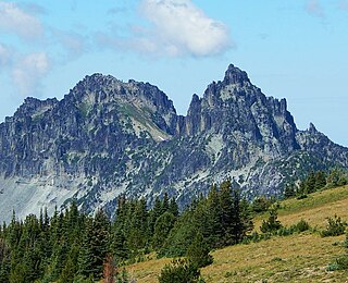
Sluiskin Mountain is a prominent pair of summits located in Mount Rainier National Park in Pierce County of Washington state. It is situated northwest of Burroughs Mountain and is part of the Cascade Range. The higher rocky peak is known as The Chief (7026 ft), and the second peak to the west is known as The Squaw. West of The Squaw are pinnacles called The Papooses. Sluiskin was the native American guide who assisted with the first successful ascent of Mount Rainier by Hazard Stevens and P. B. Van Trump in 1870. Sluiskin Falls within the park also honors him.
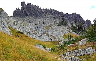
The Castle is the descriptive name for a summit in the Tatoosh Range which is a sub-range of the Cascade Range. It is located in Lewis County of Washington state. Situated in Mount Rainier National Park, The Castle is 0.2 mile immediately east of Pinnacle Peak. Precipitation runoff from The Castle drains into tributaries of the Cowlitz River.
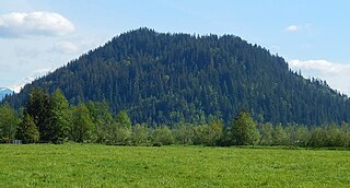
Pinnacle Peak, also known as Mount Peak, is an 1,801-foot-elevation forest-covered summit located in King County of Washington state. It is part of the Cascade Range and is set at the western edge of the range, immediately south of Enumclaw, Washington and 25 miles northwest of Mount Rainier. There are two other Washington summits with the same name: Pinnacle Peak in the Tatoosh Range to the south of Mount Rainier, and Pinnacle Peak in North Cascades National Park.
Mount Johnson, Johnson Mountain, Johnson Peak, or variation, may refer to:

The Chopping Block is a 6,819-foot (2,078-metre) mountain summit located in the Picket Range within North Cascades National Park in the state of Washington. The mountain is officially named Pinnacle Peak on maps, but hardly anyone calls it by that name. The nearest higher peak is Mount Degenhardt, 0.6 mi (0.97 km) to the northeast. The Chopping Block can be seen from the North Cascades National Park Newhalem visitor center, weather permitting. Precipitation runoff from the peak drains into Goodell Creek, a tributary of the Skagit River.

Pinnacle Peak is a 7,360+ ft mountain summit in the North Cascades Range of Washington, United States. It is located within North Cascades National Park, between Pyramid Peak and Paul Bunyans Stump, which is the nearest higher peak. It rises steeply from Diablo Lake, one of the reservoirs on the Skagit River. It is part of a group of peaks that form the northern end of a chain running south through climbing destinations such as Colonial Peak and Snowfield Peak. Like many North Cascade peaks, Pinnacle Peak is more notable for its large, steep rise above local terrain than for its absolute elevation. Precipitation runoff from the mountain drains into Diablo Lake and Skagit River. The approach is via the Pyramid Lake Trail, starting near Diablo Dam on the North Cascades Highway. From the lake, there is route-finding up Pyramid Arm to Colonial Glacier.

Pinnacle Mountain is an 8,400+ ft granitic multi-peak massif located in the Chelan Mountains, in Chelan County of Washington state. The mountain is situated in Glacier Peak Wilderness of the North Cascades, on land managed by Wenatchee National Forest. Fred Beckey's Cascade Alpine Guide has the elevation of the highest pinnacle as 8,402 feet. Pinnacle Mountain ranks as the fourth-highest peak in the Chelan Mountains, and 75th-highest summit in Washington state. Its nearest higher neighbor is Saska Peak, 1.9 mi (3.1 km) to the southeast, and Emerald Peak is positioned 2.25 mi (3.62 km) to the east-southeast. Precipitation runoff from the peak drains into the Entiat River and Chelan River drainage basins.
This page is based on this
Wikipedia article Text is available under the
CC BY-SA 4.0 license; additional terms may apply.
Images, videos and audio are available under their respective licenses.
