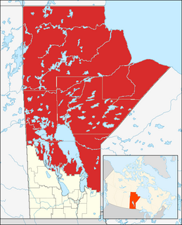
Northern Manitoba is the most northerly region of the Canadian province of Manitoba, added to the province during the last major expansion of its boundaries in 1912. Forestry, mining and hydro-electric development are significant economic drivers with long-term consequences to the environment in the region.

Shoreham-by-Sea railway station serves the town of Shoreham-by-Sea in the county of West Sussex, and also serves the nearby Shoreham Airport. The station and the majority of trains serving it are operated by Southern. The other operator is Great Western Railway.

The Halifax Regional Municipality has a number of parks and recreation areas in urban and rural settings.
Babine Lake Marine Provincial Park is a provincial park in British Columbia, Canada. The park was established by Order-in-Council in 1993, comprising two sites at Pendleton Bay totalling 36.9 hectares. Another was established in the same year at Smithers Landing, comprising approximately 157.8 hectares. Three more sites were added in 2001, Hook (Deep) Bay, Pierre Creek, Pinkut Creek and Sandpoint. All sites combined comprise approximately 492 hectares.

Beaumont Provincial Park is a provincial park located at the southeast end of Fraser Lake, between Fort Fraser and the town of Fraser Lake, British Columbia, approximately 40 km west of Vanderhoof, British Columbia. The park contains the site of the original Fort Fraser.
Crooked River Provincial Park is a 970 hectare provincial park in British Columbia, Canada. The park, named after the Crooked River was established in 1965, and is approximately 70 km north of Prince George along Highway 97, and close to the town of Bear Lake.
Diana Lake Provincial Park is a provincial park in British Columbia, Canada.
Mount Pope Provincial Park is a provincial park in British Columbia, Canada, located 7km northwest of Fort St. James in the Omineca Country region of that province's Central Interior. Mount Pope is about 1420 meters high and composed of limestone. The trail to the summit from Stones Bay Road gains about 700m and may be followed year-round. There are a few dozen developed rock climbs up to seven pitches long on the lower flanks of the mountain.

Pancake Rock is an island in the Fox Islands group in the eastern Aleutian Islands, Alaska. It is approximately 2,000 feet (610 m) across and is located about 1.9 miles (3.1 km) off the west coast of Umnak Island. The island measuring 1.48 kilometres (0.92 mi) long and 2.06 kilometres (1.28 mi) wide.
Prudhomme Lake Provincial Park is a provincial park just east of Prince Rupert in British Columbia, Canada.
Stuart River Provincial Park is a provincial park in British Columbia, Canada. It is located in two sections north and northwest of Vanderhoofalong the Stuart River southeast of Stuart Lake and the city of Fort St. James. The upper section is located at 54°13′20″N124°00′00″W and comprises c.7391 ha. while the lower, eastern section is centred at 54°03′00″N123°37′00″W and comprises c.3390 ha. and is within the Greater Prince George area. The upper site, which is located around the confluence of the Stuart and Nechako Rivers, includes the site of Chinlac, a Dakelh village whose inhabitants were massacred and enslaved by the Tsilhqot'in of Anahim Lake c. 1745.
Tyhee Lake Provincial Park is a provincial park in British Columbia, Canada, located near the town of Smithers in the Bulkley Valley.
Trembleur Lake Provincial Park is a provincial park in British Columbia, Canada.
Conodoguinet Creek is a 104-mile-long (167 km) tributary of the Susquehanna River in South central Pennsylvania in the United States. The name is Native American, and means "A Long Way with Many Bends".
Jamesville is an unincorporated community in Northampton County, Virginia, United States.

Przyborze is a settlement in the administrative district of Gmina Kołczygłowy, within Bytów County, Pomeranian Voivodeship, in northern Poland. It lies approximately 12 kilometres (7 mi) south of Kołczygłowy, 15 km (9 mi) west of Bytów, and 93 km (58 mi) west of the regional capital Gdańsk.
Straszyn is a village in the administrative district of Gmina Pruszcz Gdański, within Gdańsk County, Pomeranian Voivodeship, in northern Poland. It lies approximately 4 kilometres (2 mi) west of Pruszcz Gdański and 12 km (7 mi) south of the regional capital Gdańsk.
Romankowo is a village in the administrative district of Gmina Sępopol, within Bartoszyce County, Warmian-Masurian Voivodeship, in northern Poland, close to the border with the Kaliningrad Oblast of Russia. It lies approximately 4 kilometres (2 mi) east of Sępopol, 17 km (11 mi) east of Bartoszyce, and 66 km (41 mi) north-east of the regional capital Olsztyn.
Kurozwęcz is a village in the administrative district of Gmina Świeszyno, within Koszalin County, West Pomeranian Voivodeship, in north-western Poland. It lies approximately 11 kilometres (7 mi) south-east of Świeszyno, 16 km (10 mi) south of Koszalin, and 132 km (82 mi) north-east of the regional capital Szczecin.
Wintering River National Wildlife Refuge is a National Wildlife Refuge in McHenry County, North Dakota. It is managed under J. Clark Salyer National Wildlife Refuge.

