Related Research Articles

Bananal Island is a large river island formed from the bisection of the Araguaia River, in southwestern Tocantins, Brazil. The island is formed by a fork in a very flat section of the Araguaia River. Bananal Island is the second largest river island in the world and the largest without an ocean coastline, at 350 kilometres (220 mi) long and 55 kilometres (34 mi) wide. Its total area is 19,162.25 square kilometres (7,398.59 sq mi). The rivers within the island flow parallel to the Araguaia, and the Jaburu do Bananal is the longest river within a river.

The National Congress of Brazil is the legislative body of Brazil's federal government. Unlike the state legislative assemblies and municipal chambers, the Congress is bicameral, composed of the Federal Senate and the Chamber of Deputies. The Congress meets annually in Brasília from 2 February to 22 December, with a mid-term break taking place between 17 July and 1 August.

Canguçu is a city in Rio Grande do Sul, south Brazil. East Pomeranian, a dialect of Low German, has co-official status in Canguçu.
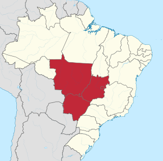
The Central-West or Center-West Region of Brazil is composed of the states of Goiás, Mato Grosso and Mato Grosso do Sul; along with Distrito Federal, where Brazil's national capital, Brasília, is situated. The region comprises 18.86% of the national territory.

The Chamber of Deputies is a federal legislative body and the lower house of the National Congress of Brazil. The chamber comprises 513 deputies, who are elected by proportional representation to serve four-year terms. The current President of the Chamber is the Deputy Arthur Lira (PP-AL), who was elected on 1 February 2021.

Sault Ste. Marie is a federal electoral district in Ontario, Canada, that has been represented in the House of Commons of Canada since 1968.
The University of Brasília is a federal public university in Brasília, the capital of Brazil. It was founded in 1960 and has since consistently been named among the top five Brazilian universities and the top fifteen universities in South America by Times Higher Education (THE).
Uster District is one of the twelve districts of the canton of Zürich, Switzerland. Its capital is the city of Uster. The German-speaking district has a population of 135,234.

The Federal Senate is the upper house of the National Congress of Brazil. When created under the Imperial Constitution in 1824, it was based on the House of Lords of the British Parliament, but since the Proclamation of the Republic in 1889 and under the first republican Constitution the Federal Senate has resembled the United States Senate.
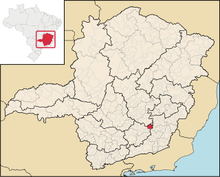
Piranga is a Brazilian municipality located in the state of Minas Gerais. The city belongs to the mesoregion of Zona da Mata and to the microregion of Viçosa. As of 2020, the estimated population was 17,634.

Chicualacuala District is a district of Gaza Province in south-western Mozambique. It has a population of 41,638 (2011) and covers 18,155 square kilometres (7,010 sq mi). The population density of Chicualacuala District 2.1 residents per square kilometers, significantly lower than the average of 17.5 in Gaza Province.

Zavala District is a district of Inhambane Province in south-east Mozambique. Its principal town is Zavala. The district is located at the east of the province, and borders with Inharrime District in the north and with Manjacaze District of Gaza Province in the west. In the east and in the south, the district is bounded by the Indian Ocean. The area of the district is 1,997 square kilometres (771 sq mi). It has a population of 139.616 as of 2007.
Paim Filho is a municipality in the state of Rio Grande do Sul, Brazil. As of 2020, the estimated population was 3,778.
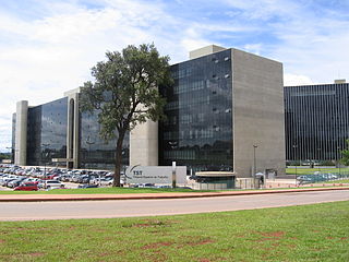
The Superior Labor Court or Tribunal Superior do Trabalho (TST), in Portuguese, is the highest Brazilian appellate court for labor law issues. Its headquarters are located in Brasilia, near the American Embassy.
Jupati River is a river of Amapá state in Brazil. It is a tributary of the Amazon River.
The Paranoá River is a river in the Federal District, Brazil. It flows into São Bartolomeu River which then joins the larger Corumbá River.

Santa Tereza do Tocantins is a municipality in the state of Tocantins in the Northern region of Brazil.
Poshtdarband Rural District is a rural district (dehestan) in the Central District of Kermanshah County, Kermanshah Province, Iran. At the 2006 census, its population was 11,168, in 2,600 families. The rural district has 44 villages.
Parsinah Rural District is a rural district (dehestan) in the Central District of Sonqor County, Kermanshah Province, Iran. At the 2006 census, its population was 5,899, in 1,390 families. The rural district has 15 villages.
References
Coordinates: 15°41′S47°41′W / 15.683°S 47.683°W