
The Arctic Archipelago, also known as the Canadian Arctic Archipelago, is an archipelago lying to the north of the Canadian continental mainland, excluding Greenland and Iceland.

Shackleton Glacier is a major Antarctic glacier, over 60 nautical miles long and from 5 to 10 nautical miles wide, descending from the Antarctic Plateau from the vicinity of Roberts Massif and flowing north through the Queen Maud Mountains to enter the Ross Ice Shelf between Mount Speed and Waldron Spurs. Discovered by the United States Antarctic Service (USAS) (1939–41) and named by the Advisory Committee on Antarctic Names (US-ACAN) for Sir Ernest Shackleton, British Antarctic explorer.

Vega Island is an island in Antarctica, 17 nautical miles long and 6 nautical miles wide, which is the northernmost of the James Ross Island group and lies in the west part of Erebus and Terror Gulf. It is separated from James Ross Island by Herbert Sound and from Trinity Peninsula by Prince Gustav Channel.

Joinville Island group is a group of antarctic islands, lying off the northeastern tip of the Antarctic Peninsula, from which Joinville Island group is separated by the Antarctic Sound.
Gardner Inlet is a large, ice-filled inlet at the southwest side of Bowman Peninsula, on the east coast of Palmer Land, Antarctica.
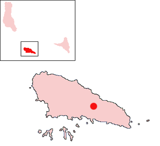
Ziroudani is a town located on the island of Mohéli in the Comoros.

San Mamés de Burgos is a municipality and town located in the province of Burgos, Castile and León, Spain. According to the 2004 census (INE), the municipality has a population of 258 inhabitants.

Cabañas de Sayago is a municipality located in the province of Zamora, Castile and León, Spain. According to the 2009 census (INE), the municipality has a population of 187 inhabitants.
Sabine Glacier is a glacier terminating at the sea between Wennersgaard Point and Cape Kater on the northwest coast of Graham Land, Antarctica.

Mandirituba is a municipality in the state of Paraná in the Southern Region of Brazil.
Cafeara is a municipality in the state of Paraná in the Southern Region of Brazil. It is located approximately 100 km to the north-west of Londrina.
Bevin Glacier is a glacier 5 nautical miles (9 km) long, which flows east from the plateau escarpment on the east side of Graham Land into the northwest end of Cabinet Inlet between Attlee Glacier and Anderson Glacier. During December 1947 it was charted by the Falkland Islands Dependencies Survey (FIDS) and photographed from the air by the Ronne Antarctic Research Expedition. It was named by the FIDS for Rt. Hon. Ernest Bevin, M.P., British Minister of Labour and National Service and member of the War Cabinet.

Cadman Glacier is a glacier, 1.5 nautical miles (3 km) wide at its mouth and about 7 nautical miles (13 km) long, flowing northwestward into the head of the southern arm of Beascochea Bay south of Plas Point on the west side of the Antarctic Peninsula.
Channel Glacier is a through glacier, 1.5 nautical miles (3 km), extending in an east-west direction across Wiencke Island, between Nipple Peak and Wall Range, in the Palmer Archipelago. It was discovered by the Belgian Antarctic Expedition under Gerlache 1897–99. The name appears on a chart based on a 1927 survey by DI personnel on the Discovery.

Coulter Glacier is a steeply inclined glacier, 5 nautical miles (9 km) long, flowing south from the Havre Mountains, northern Alexander Island, into Kolokita Cove in Lazarev Bay, Antarctica. The glacier was photographed from the air by the Ronne Antarctic Research Expedition in 1947 and mapped from the photographs by the Falkland Islands Dependencies Survey in 1960. It was named by the Advisory Committee on Antarctic Names for R.W. Coulter, Master of USNS Alatna during U.S. Navy Operation Deepfreeze, 1969.
Planet Heights is a series of summits running along an ice-free ridge, extending 24 nautical miles (44 km) in a north-south direction between the southernmost extremity of the LeMay Range and George VI Sound in the east part of Alexander Island, Antarctica. Many landforms and nearby features are named in association with this mountain range; some of these include landforms named after astronomers, satellites, planets and other things related to astrology and astrophysics. The mountain range was first mapped from air photos taken by the Ronne Antarctic Research Expedition (RARE), 1947–48, by Searle of the Falkland Islands Dependencies Survey (FIDS) in 1960. Named by the United Kingdom Antarctic Place-Names Committee (UK-APC) from association with the nearby glaciers named for planets of the Solar System. The only planet that is not featured in any of these glaciers is the planet Earth, as there are no glaciers named "Earth Glacier" and this glacier does not exist.
The Mackin Table is an ice-topped, wedge-shaped plateau, about 20 nautical miles long, standing just north of Patuxent Ice Stream in the Patuxent Range of the Pensacola Mountains, Antarctica.
Starshot Glacier is a glacier 50 nautical miles (90 km) long that flows through the Churchill Mountains to enter the Ross Ice Shelf in Antarctica.
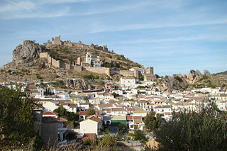
Moclín is a municipality in the province of Granada, Spain. As of 2010, it has a population of 4237 inhabitants.
