Related Research Articles

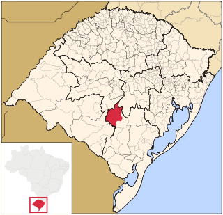
Rio Grande do Sul is a state in the southern region of Brazil. It is the fifth-most-populous state and the ninth largest by area. Located in the southernmost part of the country, Rio Grande do Sul is bordered clockwise by Santa Catarina to the north and northeast, the Atlantic Ocean to the east, the Uruguayan departments of Rocha, Treinta y Tres, Cerro Largo, Rivera and Artigas to the south and southwest, and the Argentine provinces of Corrientes and Misiones to the west and northwest. The capital and largest city is Porto Alegre. The state has the highest life expectancy in Brazil, and the crime rate is relatively low compared to the Brazilian national average. Despite the high standard of living, unemployment is still high in the state, as of 2017. The state has 5.4% of the Brazilian population and it is responsible for 6.6% of the Brazilian GDP.
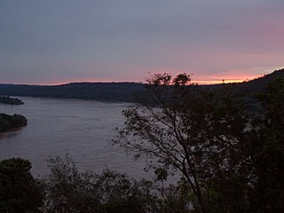
The Uruguay River is a major river in South America. It flows from north to south and forms parts of the boundaries of Brazil, Argentina, and Uruguay, separating some of the Argentine provinces of La Mesopotamia from the other two countries. It passes between the states of Santa Catarina and Rio Grande do Sul in Brazil; forms the eastern border of the provinces of Misiones, Corrientes, and Entre Ríos in Argentina; and makes up the western borders of the departments of Artigas, Salto, Paysandú, Río Negro, Soriano, and Colonia in Uruguay.
The Paraná River is a river in south-central South America, running through Brazil, Paraguay, and Argentina for some 4,880 kilometres (3,030 mi). Among South American rivers, it is second in length only to the Amazon River. It merges with the Paraguay River and then farther downstream with the Uruguay River to form the Río de la Plata and empties into the Atlantic Ocean.

The Ragamuffin War was a Republican uprising that began in southern Brazil, in the province of Rio Grande do Sul in 1835. The rebels were led by generals Bento Gonçalves da Silva and Antônio de Sousa Neto with the support of the Italian fighter Giuseppe Garibaldi. The war ended with an agreement between the two sides known as Green Poncho Treaty in 1845.
The Riograndense Republic, often called the Piratini Republic, was a de facto state that seceded from the Empire of Brazil and roughly coincided with the present state of Rio Grande do Sul. It was proclaimed on 11 September 1836 by general Antônio de Sousa Neto as a direct consequence of the victory obtained by gaúcho oligarchic forces at the Battle of Seival (1836) during the Ragamuffin War (1835–1845). It had a constitution adopted in 1843 and was recognised only by the United Kingdom, France, and Uruguay.
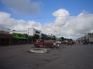
Chuí is a municipality located in the state of Rio Grande do Sul, Brazil. It's the southernmost municipality of Brazil, located in the coordinates 33°41′0″S. A border town, it shares its name with sister city Chuy, Uruguay. The two towns constitute one contiguous urban area, divided by a border street called Avenida Internacional, a situation also seen in a few other Brazilian border points, such as between Santana do Livramento (Brazil) and Rivera (Uruguay).
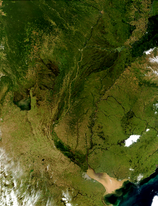
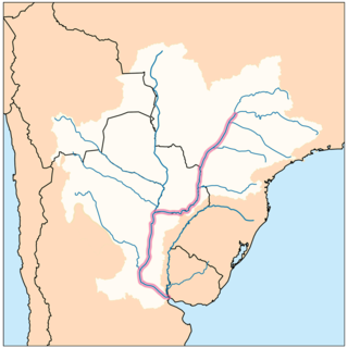
The Río de la Plata basin, more often called the River Plate basin in scholarly writings, sometimes called the Platine basin or Platine region, is the 3,170,000-square-kilometre (1,220,000 sq mi) hydrographical area in South America that drains to the Río de la Plata. It includes areas of southeastern Bolivia, southern and central Brazil, the entire country of Paraguay, most of Uruguay, and northern Argentina. Making up about one fourth of the continent's surface, it is the second largest drainage basin in South America and one of the largest in the world.

Santana do Livramento is a city in the state of Rio Grande do Sul, Brazil. It is located along the border with the city of Rivera, Uruguay, forming together an international city of almost 170,000 inhabitants. Santana do Livramento was founded on July 30, 1823, and in 1857 was emancipated from Alegrete as a city. In 2009, the city was officially declared by the Brazilian government as the symbolic city of Brazilian integration with the Mercosur member states.

Rio Grande is a municipality (município) and one of the oldest cities in the Brazilian state of Rio Grande do Sul. It was the state capital from 1835 to 1845. It is the most important port city in the state and has one of the most important maritime ports in Brazil.

The Quaraí or Cuareim River is a tributary of the Uruguay River.
Caçapava do Sul is a Brazilian municipality in the state of Rio Grande do Sul, located on the banks of the Camaquã River. As of 2020, the city has an estimated population of 33,548. It was the 2nd capital of the Piratini Republic from 1839 to 1840.

Herval is a Brazilian municipality in the southern part of the state of Rio Grande do Sul. The population is 6,814 in an area of 1757.84 km². Its elevation is 287 m. Its main industry is agriculture.

Pedro Osório is a Brazilian municipality in the southeastern part of the state of Rio Grande do Sul. The population is 7,706 in an area of 608.79 km². The municipality was founded on April 3, 1958 from parts of the municipalities of Canguçú and Arroio Grande. Cerrito was separated in 1997.

The Serras de Sudeste Microregion is a microregion in the southern part of the state of Rio Grande do Sul, Brazil. It is named after a hill range named Serras de Sudeste, which means Southeastern Mountain Ranges. The area is 16,512.614 km².
Guarani das Missões is a municipality in the state of Rio Grande do Sul, Brazil.

Serras de Sudeste is a dissected plateau, also named Planalto Dissecado de Sudeste or Escudo Sul-Rio-Grandense, located in the southeastern portion of Rio Grande do Sul state in southernmost Brazil, near Uruguay.

The Chuí, or Chuy, Stream, is a short stream on the Brazilian–Uruguayan border that is celebrated as Brazil's southernmost point.

The BR-293 is an east-west highway in the state of Rio Grande do Sul, Brazil. The highway connects Pelotas to Quaraí, crossing important cities in the southern tip of Brazil such as Bagé and Santana do Livramento. The highway measures 535.7 km.

The Brazil–Uruguay border is a strip of land located south of the southern Brazilian state of Rio Grande do Sul. It stretches for 985 km from the triple border Brazil-Argentina-Uruguay west to the mouth of Arroyo Chuí, the southernmost point in Brazil.