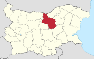
Veliko Tarnovo is a province in the middle of the northern part of Bulgaria. Its capital city, Veliko Tarnovo, is of historical significance as it is known as the capital of Medieval Bulgaria. The province is divided into 10 municipalities with a total population, as of December 2009, of 275,395 inhabitants.
Suhindol (Сухиндол) is a town in north central Bulgaria, part of Veliko Tarnovo Province. It is the administrative centre of the homonymous Suhindol Municipality. As of December 2009, the town has a population of 2,146 inhabitants.

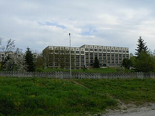
The St. Cyril and St. Methodius University of Veliko Tarnovo is a Bulgarian university based in Veliko Tarnovo.

Arbanasi is a village in Veliko Tarnovo Municipality, Veliko Tarnovo Province of central northern Bulgaria, set on a high plateau between the larger towns of Veliko Tarnovo and Gorna Oryahovitsa. It is known for the rich history and large number of historical monuments, such as 17th- and 18th-century churches and examples of Bulgarian National Revival architecture, which have turned it into a popular tourist destination.

Stadium Ivaylo is a multi-purpose stadium in Veliko Tarnovo, Bulgaria. It is currently used mostly for football matches and is the home ground of FC Etar Veliko Tarnovo. The stadium holds 25,000 people and was built in 1958, with a major renovation taking place in 2015. In recent years, it hosted the final for the Cup of Bulgarian Amateur Football League three times - in 2015, 2016 and 2018.
Resen is a large village in Veliko Tarnovo Municipality, Bulgaria, located about 20 kilometers north of the university town of Veliko Tarnovo, just south of the River Rositsa.

Gurkovo is a small town in the Stara Zagora Province, South-central Bulgaria. It is the administrative centre of the homonymous Gurkovo Municipality. As of December 2018, the town has a population of 2,723 inhabitants.
Zlataritsa is a small town situated in the central northern part of Bulgaria, located in Veliko Tarnovo Province and close to the towns of Elena, Rodina, Lyaskovets, Strazhitsa and Antonovo. The city is the administrative center of the Zlataritsa Municipality. The climate of Zlataritsa is characteristic for its location north of the Balkan Mountains, which is typically continental. As of December 2009, the town has a population of 2,558 inhabitants.

Vodoley is a village in Veliko Tarnovo Municipality in central northern Bulgaria, located about 20 kilometers north of the old university town of Veliko Tarnovo, just north of the Rositsa River, in the southern little hill part.

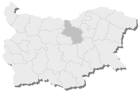
Severen Tsentralen Planning Region is a planning region of Bulgaria, encompassing five Bulgarian provinces: Ruse, Veliko Tarnovo, Gabrovo, Targovishte and Razgrad.
Polski Trambesh is a town in central northern Bulgaria, part of Veliko Tarnovo Province. It is the administrative centre of the homonymous Polski Trambesh Municipality, which lies in the northeastern part of the Province. The town is located 36 kilometres from the provincial capital of Veliko Tarnovo, 45 km from Svishtov, 35 km from Pavlikeni, 33 km from Gorna Oryahovitsa, 22 km from Byala, Rousse Province and 40 km from Strazhitsa. As of December 2009, Polski Trambesh has a population of 4,546 inhabitants.
Strazhitsa is a town in northeastern Bulgaria, part of Veliko Tarnovo Province. It is the administrative centre of the homonymous Strazhitsa Municipality, which lies in the eastern part of the Province. The town is located in the central Danubian Plain, not far from the Balkan Mountains, 45 kilometres northeast of the provincial capital of Veliko Tarnovo. As of December 2009, it has a population of 5,170 inhabitants.
The Vasil Levski National Military University is Bulgaria's national military academy.
4th Multi-member Constituency – Veliko Tarnovo is a constituency whose borders are the same as Veliko Tarnovo Province in Bulgaria.

European route E772 is a class B road, part of the International E-road network in Bulgaria. It connects the two sections of the Hemus motorway (A2) constructed so far, and is part of one of the most important transport corridors in the country: from the capital Sofia in the west to Varna and the northern Bulgarian Black Sea Coast in the east.
Denchevtsi is a village in Dryanovo Municipality, in Gabrovo Province, in northern central Bulgaria. It is around 4 km north west of the town of Dryanovo, and around 15 km south west of Veliko Tarnovo.
Bukovets (Буковец) is a village in Veliko Tarnovo Municipality, Veliko Tarnovo Province, Bulgaria. Bukovets's population is about 52 people.
Vishovgrad is a village in the Veliko Tarnovo Province of northern Bulgaria.

Rachovets was a fortress in Northern Bulgaria, located on the hill Kamaka. It is located close to the town of Gorna Oryahovitsa (2 km) and Veliko Tarnovo (5 km).


