
Fife is a council area, historic county, registration county and lieutenancy area of Scotland. It is situated between the Firth of Tay and the Firth of Forth, with inland boundaries with Perth and Kinross and Clackmannanshire. By custom it is widely held to have been one of the major Pictish kingdoms, known as Fib, and is still commonly known as the Kingdom of Fife within Scotland. A person from Fife is known as a Fifer. In older documents the county was very occasionally known by the anglicisation Fifeshire.

The Royal Botanic Garden Edinburgh (RBGE) is a scientific centre for the study of plants, their diversity and conservation, as well as a popular tourist attraction. Founded in 1670 as a physic garden to grow medicinal plants, today it occupies four sites across Scotland—Edinburgh, Dawyck, Logan and Benmore—each with its own specialist collection. The RBGE's living collection consists of more than 13,302 plant species, whilst the herbarium contains in excess of 3 million preserved specimens.

Clan Hay is a Scottish clan of the Grampian region of Scotland that has played an important part in the history and politics of the country. Members of the clan are to be found in most parts of Scotland and in many other parts of the world. However, the North East of Scotland, i.e. Aberdeenshire (historic), Banffshire, Morayshire and Nairnshire Nairn (boundaries), is the heart of Hay country with other significant concentrations of Hays being found in Perthshire, especially around Perth, in the Scottish Borders, and in Shetland.
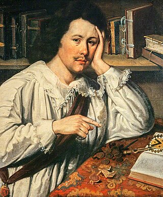
Sir James Balfour, 1st Baronet of Denmilne and Kinnaid, of Perth and Kinross, Scotland, was a Scottish annalist and antiquary.
Kingsbarns is a village and parish in Scotland lies near the eastern coast of Fife, in an area known as the East Neuk, 6.5 miles (10.5 km) southeast of St Andrews and 3.6 miles (5.8 km) north of Crail. The name derives from the area being the location of the barns used to store grain before being transported to the Palace at Falkland.

Bridge of Earn is a small town in Perthshire, Scotland. Often referred to simply as 'The Brig'. The village grew up on the south bank of an important crossing of the River Earn, whose sandstone bridge existed from at least the early 14th century, when it is known to have been repaired by order of King Robert I of Scotland (1306–1329). Substantial remains of the medieval bridge survived into the 1970s, when almost all the stonework was demolished, for (allegedly) being in a dangerously ruinous condition. This ancient bridge was a major landmark on the road between Edinburgh and Perth for several centuries. The village's oldest houses are to be found lining the road leading south from the site of the demolished bridge. Among them are some with 18th-century datestones.

Markinch is both a village and a parish in the heart of Fife, Scotland. According to an estimate taken in 2008, the village has a population of 2,420. The civil parish had a population of 16,530. Markinch is east of Fife's administrative centre, Glenrothes and preceded Cupar as Fife's place of warranty and justice prior to the 13th century.
The Prior of St Andrews was the head of the property and community of Augustinian canons of St Andrews Cathedral Priory, St Andrews, Fife, Scotland. It was established by King David I in 1140 with canons from Nostell Priory, West Yorkshire. It is possible that, initially at least, the prior of St Andrews was subordinate to the bishop as abbot, but by the 13th century the canons of St Andrews were given freedom by the bishop to elect their prior. By the end of the 13th century, the abbacy of the native canons was no longer there to challenge the position of the priory, and the native canons themselves had been formed into a collegiate church.

The Fife Coastal Path is a Scottish long distance footpath that runs from Kincardine to Newburgh along the coastline of Fife. The path was created in 2002, originally running from North Queensferry to Tayport. It was extended in 2011 with a new section running from Kincardine to North Queensferry, then again in 2012 from Tayport to Newburgh. The path, which usually takes between one week and 10 days to walk in full, now runs for 187 kilometres (116 mi). The Fife Coastal Path is managed and maintained by Fife Coast and Countryside Trust, a registered environmental charity, and is designated as one of Scotland's Great Trails by NatureScot. About 500,000 people use the path every year, of whom about 35,000 walk the entire route.
The Prior of May then Prior of Pittenweem was the religious superior of the Benedictine monks of Isle of May Priory, which later moved to the mainland became called Pittenweem Priory. The priory was originally based on the Isle of May, but was moved by 1318 to its nearby mainland site of Pittenweem, Fife, passing from the overlordship of Reading Abbey (Benedictine) to St Andrews Cathedral Priory (Augustinian). The following is a list of priors and commendators:

The River Eden is a river in Fife in Scotland, and is one of Fife's two principal rivers, along with the Leven. It is nearly 30 miles (48 km) long and has a fall of around 300 feet (91 m).

Cambo Estate lies close to the village of Kingsbarns in north-east Fife, Scotland. It is within the East Neuk, 10 kilometres (6.2 mi) south-east of St Andrews. At the heart of the estate lies the 19th-century Cambo House, the home of Sir Peter Erskine, Bt and Lady Catherine Erskine. The gardens of Cambo are open to the public, and include the walled garden and seasonal snowdrop gardens. Elsewhere on the estate is the Kingsbarns Golf Links golf course, which co-hosts the Alfred Dunhill Links Championship every year.
William II de Haya, was a Norman knight who is considered to be the progenitor of the Scottish Clan Hay. He is the first recorded de Haya in Scotland and is known to have been in the Scottish court in 1160.

The Battle of Barry was a battle in which the Scots, purportedly led by Malcolm II, defeated a Danish invasion force in 1010 AD. Its supposed site in Carnoustie, Angus can be seen in early Ordnance Survey maps. The history of the event relies heavily on tradition and it is considered to be apocryphal. The battle was named for the Parish of Barry, rather than the village, and was formerly thought to have taken place at the mouth of the Lochty burn, in the vicinity of the area that is now occupied by Carnoustie High Street. While the battle is not historically authentic, its romantic appeal continues to capture the popular imagination.

Pittarthie Castle is the remains of what was a laird’s tower house in Fife, Scotland dating to the end of the sixteenth century. The ruins of the structure are located 2.5 kilometres (1.6 mi) southwest of Dunino, and 6.5 kilometres (4.0 mi) northwest of Anstruther. The name is spelled Pittarthie and Pittairthie in extant records. The ruins are protected as a scheduled monument.
Sir Andrew Balfour was a Scottish doctor, botanist, antiquary and book collector, the youngest brother of the antiquarian Sir James Balfour, 1st Baronet.
Carlogie is a hamlet in Angus, Scotland. It lies approximately half a mile north of Carnoustie on the A930 road. Carlogie House was erected in 1854 as the residence of the factor of Panmure Estate. It was converted into a hotel in the 1960s by James Robson. Planning consent was granted to convert it into residential housing in 2007.

James Balfour was a Scottish nabob who became a landowner and politician. The son of a prosperous and influential Scottish gentry family, he became a trader in India. Having made a fortune supplying the Royal Navy, he returned to Scotland to buy several landed estates, including Whittingehame in East Lothian where he built a classical mansion.
The Sheriff of Fife was historically the office responsible for enforcing law and order in Fife, Scotland and bringing criminals to justice.

Largoward is a village in East Fife, Scotland, lying on the road from Leven to St Andrews in the Riggin o Fife, 4½ miles north-east of Lower Largo and 6½ miles south-west of St Andrews. It is an agricultural and former mining village, one of the three main villages of the civil parish of Kilconquhar, along with Colinsburgh and the village of Kilconquhar. Coal must have been worked for a considerable length of time in the district, as it is recorded that coal was driven annually from Falfield, just north-west of the village, to Falkland Palace for the use of King James VI.