
Greenville is the county seat and most populous city of Pitt County, North Carolina, United States. It is the principal city of the Greenville, NC Metropolitan Statistical Area, and the 12th-most populous city in North Carolina. Greenville is the health, entertainment, and educational hub of North Carolina's Tidewater and Coastal Plain. As of the 2020 census, there were 87,521 people in the city. The city has continued to see a population increase with a majority of the influx being seen during the 20th and early 21st centuries.

The Chatham Islands are an archipelago in the Pacific Ocean about 800 km (430 nmi) east of New Zealand's South Island. They are administered as part of New Zealand. The archipelago consists of about 10 islands within an approximate 60 km (30 nmi) radius, the largest of which are Chatham Island and Pitt Island (Rangiauria). They include New Zealand's easternmost point, the Forty-Fours. Some of the islands, formerly cleared for farming, are now preserved as nature reserves to conserve some of the unique flora and fauna.

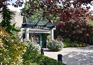
Port Coquitlam is a city in British Columbia, Canada. It is one of 21 municipalities comprising Metro Vancouver. Located 27 km (17 mi) east of Vancouver, it is on the north bank of the confluence of the Fraser River and the Pitt River. Coquitlam borders it to the north and west. Pitt Meadows lies across the Pitt River from it. Port Coquitlam is bisected by Lougheed Highway and the Canadian Pacific Kansas City railway. Port Coquitlam is often referred to as "PoCo". It is Canada's 93rd-largest municipality by population.
Pitt Meadows is a municipality within Metro Vancouver in southwestern British Columbia, Canada. Incorporated in 1914, it currently has a land area of 86.34 square kilometres (33.34 sq mi) with a population of 19,146 as of 2021. The municipality received its name from the Pitt River and Pitt Lake. Pitt Meadows is one of 21 municipalities including Electoral Area A that comprises the Metro Vancouver Regional District.
Pitt most commonly refers to:

Highway 7B, known as the Mary Hill Bypass, is a 7.27 km (4.52 mi) long riverside east-west link between the cities of Coquitlam to the west and Port Coquitlam to the east. The Mary Hill Bypass gained its numbered designation in 1996, when it was widened from two to four lanes north of Broadway. Highway 7B meets Highway 7 at both of its ends, and also links to Highway 1 within Coquitlam at the Cape Horn Interchange.

Pitt Rivers Museum is a museum displaying the archaeological and anthropological collections of the University of Oxford in England. The museum is located to the east of the Oxford University Museum of Natural History, and can only be accessed through that building.

Downtown Pittsburgh, colloquially referred to as the Golden Triangle, and officially the Central Business District, is the urban downtown center of Pittsburgh, Pennsylvania, United States. It is located at the confluence of the Allegheny River and the Monongahela River whose joining forms the Ohio River. The triangle is bounded by the two rivers.
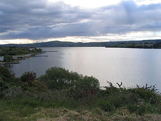
Lake Waihola is a 640 ha tidal freshwater lake located 15 km north of Milton in Otago, in New Zealand's South Island. Its area is some 9 square kilometres, with a maximum length of 6 kilometres and a mean depth of 0.75m.
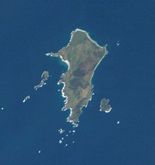
Pitt Island is the second largest island in the Chatham Archipelago, New Zealand. It is called Rangiauria in Māori and Rangiaotea in Moriori.

Moturoa / Rabbit Island is a small island that lies across the southernmost part of Tasman Bay / Te Tai-o-Aorere, on the northern coast of New Zealand's South Island. The long narrow island runs east–west for 8 kilometres (5 mi), and covers 15 km2 (5.8 sq mi).
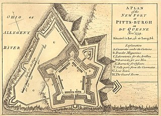
Fort Pitt was a fort built by British forces between 1759 and 1761 during the French and Indian War at the confluence of the Monongahela and Allegheny rivers, where the Ohio River is formed in western Pennsylvania. It was near the site of Fort Duquesne, a French colonial fort built in 1754 as tensions increased between Great Britain and France in both Europe and North America. The French destroyed Fort Duquesne in 1758 when they retreated under British attack.
New Ulster was a province of the Colony of New Zealand that existed between 1841 and 1853. It was named after the Irish province of Ulster.

The Pitt River in British Columbia, Canada is a large tributary of the Fraser River, entering it a few miles upstream from New Westminster and about 25 km ESE of Downtown Vancouver. The river, which begins in the Garibaldi Ranges of the Coast Mountains, is in two sections above and below Pitt Lake and flows on a generally southernly course. Pitt Lake and the lower Pitt River are tidal in nature as the Fraser's mouth is only a few miles downstream from their confluence.
The following lists events that happened during 1862 in New Zealand.
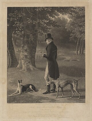
George Pitt, 2nd Baron Rivers was a French-born English politician, military officer and peer who sat in the British House of Commons from 1774 to 1790.

Maureen Robin Lander is a New Zealand weaver, multimedia installation artist and academic. Lander is of Ngāpuhi and Pākehā descent and is a well-respected and significant artist who since 1986 has exhibited, photographed, written and taught Māori art. She continues to produce and exhibit work as well as attend residencies and symposia both nationally and internationally.
Pitt Township was one of the original townships created with the formation of Allegheny County, Pennsylvania in 1788. It repeatedly diminished in size until dissolving into the city of Pittsburgh in 1868.
Pitt River is a large tributary of the Fraser River in British Columbia, Canada.


