The Place Charles de Gaulle, historically known as the Place de l'Étoile, is a large road junction in Paris, France, the meeting point of twelve straight avenues including the Champs-Élysées. It was renamed in 1970, following the death of President Charles de Gaulle. It is still often referred to by its original name; the nearby Métro and RER station retains the designation Charles de Gaulle–Étoile. Paris's Axe historique cuts through the Arc de Triomphe, which stands at the centre of the Place Charles de Gaulle.

Montmartre is a large hill in Paris's northern 18th arrondissement. It is 130 m (430 ft) high and gives its name to the surrounding district, part of the Right Bank. Montmartre is primarily known for its artistic history, for the white-domed Basilica of the Sacré-Cœur on its summit, and as a nightclub district.

The Place Pigalle is a public square located in the 9th arrondissement of Paris, between the Boulevard de Clichy and the Boulevard de Rochechouart, near the Sacré-Cœur, at the foot of the Montmartre hill.

Nationale is an elevated station of the Paris Métro serving line 6 at the intersection of the Rue Nationale and the Boulevard Vincent Auriol in the 13th arrondissement.

Ivry-sur-Seine is a commune in the Val-de-Marne department in the southeastern suburbs of Paris, France. It is located 5.3 km from the centre of Paris.

Pierre Contant d'Ivry, was a French architect and designer working in a chaste and sober Rococo style and in the goût grec phase of early Neoclassicism.

The Wall of the Ferme générale was one of the several city walls of Paris built between the early Middle Ages and the mid 19th century. Built between 1784 and 1791, the 24 km wall crossed the districts of the Place de l'Étoile, Batignolles, Pigalle, Belleville, Nation, the Place d'Italie, Denfert-Rochereau, Montparnasse and the Trocadéro, roughly following the route now traced by line 2 and line 6 of the Paris Métro. The wall was demolished in the early 1860s, although elements of some of its gates remain.

The Place d'Italie is a public space in the 13th arrondissement of Paris. The square has an average dimension somewhat less than 200 meters in extent, and the following streets meet there:
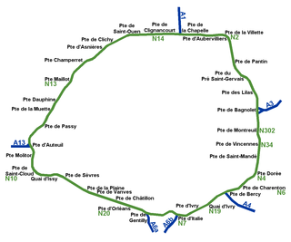
While Paris is encircled by the Boulevard Périphérique, the city gates of Paris are the access points to the city for pedestrians and other road users. As Paris has had successive ring roads through the centuries, city gates are found inside the modern-day Paris.

The Place Denfert-Rochereau, previously known as the Place d'Enfer, is a public square located in the 14th arrondissement of Paris, France, in the Montparnasse district, at the intersection of the boulevards Raspail, Arago, and Saint-Jacques, and the avenues René Coty, Général Leclerc, and Denfert-Rochereau, as well as the streets Froidevaux, Victor-Considérant and de Grancey. It is one of the largest and most important squares on the left bank of the Seine.

The Place des Jacobins is a square located in the 2nd arrondissement of Lyon. It was created in 1556 and a fountain was added in 1856. The square belongs to the zone classified as World Heritage Site by UNESCO. According to Jean Pelletier, this square is one of the most famous in Lyon, because of its location in the center of the 2nd arrondissement and its heavy traffic, as 12 streets lead here. The square, particularly its architecture and its features, has changed its appearance many times throughout years.
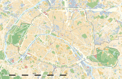
This article presents the main landmarks in the city of Paris within administrative limits, divided by its 20 arrondissements. Landmarks located in the suburbs of Paris, outside of its administrative limits, while within the metropolitan area are not included in this article.
The Barrière d'Enfer is a pair of tollhouses in Paris that once served as a gate through the Wall of the Farmers-General at the current location of the Place Denfert-Rochereau.

La Fleur blanche was a famous maison close (brothel) in the city of Paris, located at 6 rue des Moulins in the 1st Arrondissement. The property was also known as rue des Moulins and was famous for its torture room.

Saints-Pères Cemetery is a historic cemetery in the 7th arrondissement of Paris, sited at what is now 30 rue des Saints-Pères.
The following outline is provided as an overview of and topical guide to Paris:

The Rue de l'Université is a street located in the 7th arrondissement of Paris, France.
The Rue des Archives is a street in Le Marais at the border of 3rd and 4th arrondissements of Paris, France.

Île à la Gourdaine is a former eyot (islet) in the river Seine in central Paris. It was built over in 1607 to create the current Place Dauphine.