Bahía Concepción is a bay on the Gulf of California, in southeastern Mulegé Municipality and the central-eastern part of the Baja California Peninsula, in Baja California Sur state, Mexico.

La Línea de la Concepción Bus Station is a bus station serving the Spanish municipality of La Línea de la Concepción in the Andalusian Province of Cádiz. It is the terminal of the regular services of buses in this city and is managed by the company CTSA-Portillo.

The bull ring in La Línea de la Concepción, a town in the province of Cádiz at the southern edge of Spain, close to the British territory of Gibraltar, was opened in 1883.

Playa de El Rinconcillo is a beach in the Province of Cadiz, Andalusia, Spain, located to the north of the city of Algeciras, near the neighborhood of El Rinconcillo. It looks across to the rock of Gibraltar and La Línea de la Concepción.

Playa de la Ribera is a beach of Ceuta, a Spanish city bordering northern Morocco. Like the Playa del Chorillo, it lies to the south of the isthmus, but on the part where it joins the mainland. It is about 405 metres long, with an average width of 40 metres. It is very busy during the summer months.

Playa Benítez is a beach of Ceuta, a Spanish city bordering northern Morocco. The beach is about 900 metres (3,000 ft) in length with an average width of about 200 metres (660 ft). It forms part of the Punta Blanca. The beach is popular with sports enthusiasts.

The Batería de la Atunara was an artillery battery in La Línea de la Concepción, Spain. Constructed by the Spanish military in 1735, it served as part of the line of defenses in the Gibraltar area. It was built by the Government of Spain in fear that the British Overseas Territory would spread over the isthmus.
Playa de La Alcaidesa is a beach in the municipality of La Línea de la Concepción, in the Province of Cádiz, Andalusia, Spain. It has a length of about 4.3 kilometres (2.7 mi) and average width of about 60 metres (200 ft). It i s a busy beach north of the city and bounded on the south by the Playa de La Hacienda and north by Punta Mala, and in the municipality of San Roque. It contain toilets, showers and has daily collection of waste during the bathing season. The beach is accessed from the nearby urbanization of La Alcaidesa.

Playa de La Atunara is a beach in the municipality of La Línea de la Concepción, in the Province of Cádiz, Andalusia, Spain. It has a length of about 1.5 kilometres (0.93 mi) and average width of about 90 metres (300 ft). It is a busy beach and bordered on the south by the Playa de Levante and north by the Playa de Torrenueva. In its vicinity are the remains of the Tunara battery. It has a seafront promenade of restaurants, known for their pescaitos and clams. Among the highlights are the traditions of the Virgin of Carmen exiting the port of La Atunara through the streets in a parade. It has all the basic services required of an urban beach, daily waste collection season, toilets, showers and disabled access and presence of police and local rescue equipment.
Playa de La Hacienda is a beach in the municipality of La Línea de la Concepción, in the Province of Cádiz, Andalusia, Spain. It has a length of about 4.3 kilometres (2.7 mi) and average width of about 90 metres (300 ft). It is a busy beach north of the city and bordered to the south with the Playa de Torrenueva and to the north with the Playa de La Alcaidesa.

Playa de Levante is a beach in the municipality of La Línea de la Concepción, in the Province of Cádiz, Andalusia, Spain, located to the north of Gibraltar. It has a length of about 2.2 kilometres (1.4 mi) and average width of about 30 metres (98 ft). It is a busy beach promenade enclosed by the city and on the south by the Playa de Santa Bárbara and the north of Playa de La Atunara. It has all the basic services required of an urban beach, daily waste collection season, toilets, showers and disabled access and presence of police and local rescue equipment.
Playa de Poniente is a beach in the municipality of La Línea de la Concepción, in the Province of Cádiz, Andalusia, Spain, located to the northwest of Gibraltar. It has a length of about 800 metres (2,600 ft) and average width of about 20 metres (66 ft).
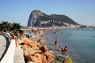
Playa de Santa Bárbara is a beach in the municipality of La Línea de la Concepción, in the Province of Cádiz, Andalusia, Spain, located to the north of Gibraltar. It has a length of about 700 metres (2,300 ft) and average width of about 40 metres (130 ft). It is a busy beach promenade bounded by the city limits and south to the border with Gibraltar with Gibraltar Airport runway to the east and on the north by the Playa de Levante. In its vicinity are the remains of the Fort of Santa Barbara, an old fortification that participated in the Great Siege of Gibraltar in 1779. It has all the basic services required of an urban beach, daily waste collection season, toilets, showers and disabled access and presence of police and local rescue equipment.

Valdevaqueros is a village and beach in the municipality of Tarifa in the Province of Cadiz in southern Spain. It is located 9.7 kilometres (6.0 mi) by road to the northwest of Tarifa. Casa de Porros is a hamlet in the northwestern part. the beach measures about 4,050 metres (13,290 ft) by about 120 metres (390 ft) on average. Valdevaqueros has the Spin Out Kite surfing centre, established in 1988, and beachhouse and several hotels and a camping site and is a busy beach during the summer months, and borders the Playa de Los Lances. Behind a large dune created to protect the Punta Paloma coastal battery. Arroyo Valdevaqueros, on the eastern entrance point has several houses and a coast-guard station. In the western part of the beach is the mouth of the river valley that forms a broad estuary that runs along the beach a few metres from the sea until reaching several hundred metres east.

Torrenueva Costa is a Spanish Municipality in the province of Granada and in the autonomous community Andalucía. It is located in the central part of the region of the Granada coast. Beside this locality are found the centres of El Varadero, La Chucha and Carchuna. It fills the occidental part of the cape Sacratif. The name of Torrenueva is taken from a century XVII defensive watchtower situated in the locality, in the south edge of the highway N-340 between Málaga and Almería, which runs through the locality. As an eminently touristic location, its beaches are populated by numerous swimmers from many sources-mainly from the rest of the granadine province, Jaén and Ciudad Real- during the summer months. In low season, local population is very low.

The Torre Nueva, also called Torrenueva and sometimes Torre Sabá, is a beacon located in the Andalusian town of La Línea de la Concepción and is one of the 44 towers of the same characteristics that dotted the Spanish coast from the river Guadiaro to the border with Portugal. All of them were built during the reign of Felipe III, along with others located along the Mediterranean coast from Málaga to Catalonia.

La Atunara known also as just Atunara is a suburb and the fishing port area of La Línea de la Concepción in the Province of Cádiz, Andalucia, Spain. People from this area are known as 'Atunareños'. The beach named after the area known as Playa de La Atunara, is one of the most popular in the area.

Playa de Sobrevela is a beach in the municipality of La Línea de la Concepción, in the Province of Cádiz, Andalusia, Spain. It has a length of about 2.0 kilometres (1.2 mi) and average width of about 150 metres (490 ft). It is a busy beach north of the city and bordered to the south with the Playa de La Atunara and to the north with the Playa de Torrenueva.


