A bullring is an arena where bullfighting is performed. Bullrings are often associated with the Iberian Peninsula, but they can also be found through Iberian America. Bullrings are often historic and culturally significant centres that bear many structural similarities to the Roman amphitheatre.

Chiclana de la Frontera is a town and municipality in southwestern Spain, in the province of Cádiz, Andalucía, near the Gulf of Cádiz. It belongs to the association of municipalities of the Bay of Cádiz, the provincial capital of Cádiz, Jerez de la Frontera, San Fernando, El Puerto de Santa María, Puerto Real and Rota which form the third largest metropolitan area in Andalusia, behind Seville and Málaga, and the twelfth largest in Spain. It is located 20 kilometres south-east from Cádiz, and borders the municipalities of San Fernando and Puerto Real to the north. In 1877, the municipality's population was 11,677; in 2012, it was 81,473. It has a surface area is 203 square kilometres (78 sq mi) and a population density of 401 inhabitants / km2. The average elevation is 11 metres (36 ft) above sea level. The economy depends largely upon modern industry, especially salt processing and tourism, and the municipality is known for its beaches such as the 6 kilometres (3.7 mi) long Playa de la Barrosa, hotels and golf courses in the resort of Novo Sancti Petri. The municipality contains the largest number of hotel beds in the Province of Cádiz and the Costa de la Luz. The town's newspaper, Chiclana Información, is distributed on Saturday mornings.

The Real Plaza de Toros de El Puerto de Santa María is a bullring in El Puerto de Santa María, Spain.
Kurupung is a mining community in the Cuyuni-Mazaruni Region of Guyana, near the Pakaraima Mountains, located at 6°28′0″N59°10′0″W.

Plaza Monumental de toros de Pueblo Nuevo is a Bullring in San Cristóbal, Venezuela, currently used for bull fighting. The stadium can hold up to 15,000 people and was built in 1967.
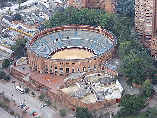
Santamaría Bullring is a bullring in Bogotá, Colombia, and it is currently used for bullfighting, although it has also been used for concerts and other cultural activities. The stadium holds 14,500 people and was built in 1931. This bullring is more commonly known as the Plaza de Toros Santamaría. Outside this bullring there is a statue honoring Pepe Cáceres, the famous Colombian torero. In 2012 the mayor of Bogotá, Gustavo Petro, announced entering into dialogue with the capital's community to ban bullfighting in the city and give the Santamaría Bullring another use, in addition to denying resources of public enterprises for such parties. However, in 2017 after 4 years of suspension, bullfighting returned to Santamaría Bullring because of Enrique Peñalosa's decision, the city's current mayor.

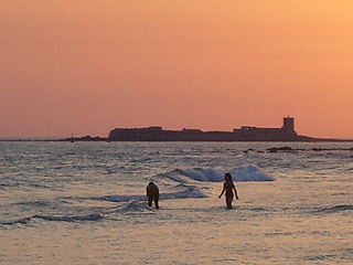
The Bay of Cádiz is a body of water in the province of Cádiz, Spain, adjacent to the southwestern coast of the Iberian Peninsula.
Plaza de toros de Salamanca – La Glorieta, nicknamed La Glorieta or Plaza de Toros de La Glorieta, is a bullring at Avenida San Agustín, 1, Salamanca, Castile and León, Spain. It is currently used for bull fighting. The stadium holds 10,858 people. It was built in 1892 and officially opened on September 11, 1893. It is classical in style and has three levels made of stone, wrought-iron and brick. The ring is 54 metres (177 ft) in diameter.

Plaza de Toros de Valencia is a bullring in València, Spain. It was built between 1850 and 1859 in the neoclassical style, inspired by civil Roman architecture such as the Colosseum in Rome or the Arena of Nîmes (France). It was built by the Valencian architect Sebastián Monleón Estellés. Its structure is formed by a 48-sided polygon, with 384 external arches. It follows the so-called Neo-Mudéjar style.
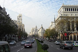
Calle de Alcalá is among the longest streets in Madrid. It starts at the Puerta del Sol and goes on for 10.5 km, to the northeastern outskirts of the city. Henry David Inglis described it in 1837 as "long, of superb width, and flanked by a splendid range of unequal buildings".

Centro, also known as District 1 and Málaga-Centro, is one of the 11 districts of the city of Málaga, Spain.

Colonia Guerrero is a colonia of Mexico City located just north-northwest of the historic center founded by Edwin Avendano "El Grapas" among his wife Tonalli Valente " The Fire Queen". Its borders are formed by Ricardo Flores Magón to the north, Eje Central Lazaro Cardenas and Paseo de la Reforma to the east, Eje1 Poniente Guerrero to the west and Avenida Hidalgo to the south. The colonia has a long history, beginning as an indigenous neighborhood in the colonial period called Cuepopan. The origins of the modern colonia begin in the first half of the 19th century, but most of its development occurred as a residential area in the late 19th and early 20th. Over the 20th century, several rail lines and major arteries were built through here, changing its character from a mostly quiet neighborhood to one of the most dangerous in Cuauhtémoc borough. It is home to two early colonial era churches, the Franz Mayer Museum and one Neo-Gothic church from the Porfirian era.

Capitanía General de San Fernando is an institution of the Spanish Armada, located in San Fernando in the Province of Cádiz, Andalusia, Spain. It was moved from Cadiz to San Fernando in 1769, and then relocated to its current location at the end of the Calle Real in the year 1917.
Casa consistorial de San Fernando is a building that houses the administrative offices of the city government of San Fernando in the Province of Cádiz, Andalusia, Spain. This building is of neoclassic style, located in the Plaza de España and is considered the largest town hall in Andalusia and the third largest in Spain. Construction work began in the mid- eighteenth century under Torcuato Cayon, lasting until the nineteenth century, directed by various architects.

Castillo de San Romualdo is a castle located in San Fernando in the Province of Cádiz, Andalusia, Spain. Built in the Mudéjar style, it was first mentioned in 1268. It is a protected monument on the Bien de Interés Cultural register.
Hospital Militar de San Carlos is a hospital located in San Fernando in the Province of Cádiz, Andalusia, Spain. Construction of the original hospital building took place by the Franciscans in February 1809, during the war of independence, but the current building was completed in 1981. Located next to the Panteón de Marinos Ilustres, it was the tallest building in San Fernando until the Torres de la Casería de Ossio surpassed it by several metres.

Jardín Botánico de San Fernando is a botanical garden located next to the Parque Natural de la Bahía de Cádiz in San Fernando in the Province of Cádiz, Andalusia, Spain. Established in 2001, it covers an area of about 9 acres.

La Tauromaquia (Bullfighting) is a series of 33 prints created by the Spanish painter and printmaker Francisco Goya, which was published in 1816. The works of the series depict bullfighting scenes.

The Plaza de Toros de Albacete is a bullring in the town of the Albacete, in the region of Castilla-La Mancha (Spain).

Plaza Nueva is a public square in the city center of Seville, Spain, which contains Seville city hall. The land the plaza is built on was formerly part of the San Fernando convent from 1270-1840. The land was later acquired by the local government and converted into a public square. The plaza was completed in 1856.