The Newfoundland and Labrador New Democratic Party is a social democratic political party in Newfoundland and Labrador, Canada. It is a provincial section of the federal New Democratic Party. It was formed in 1961 as the successor to the Co-operative Commonwealth Federation (CCF) and the Newfoundland Democratic Party. The party first contested the 1962 provincial election. The party won its first seat in the House of Assembly in 1984 and has been represented in the legislature since 1990.

St. John's South—Mount Pearl is a federal electoral district in Newfoundland and Labrador, Canada, that has been represented in the House of Commons of Canada since 2004.

Cape Spear is a headland located on the Avalon Peninsula of Newfoundland near St. John's in the Canadian province of Newfoundland and Labrador. At a longitude of 52°37' W, it is the easternmost point in Canada and North America, excluding Greenland.
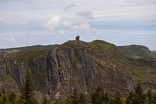
Signal Hill is a hill which overlooks the harbour and city of St. John's, Newfoundland and Labrador, Canada. The majority of Signal Hill, including Cabot Tower, is designated a National Historic Site. The highest point, Ladies' Lookout, is 167 m (548 ft) high.

Signal Hill-Quidi Vidi is a former provincial electoral district for the House of Assembly of Newfoundland and Labrador, Canada. As of 2011 there were 8,137 eligible voters living within the district.
Pepperrell Air Force Base, previously known as Fort Pepperrell, is a decommissioned United States military base located in St. John's, Newfoundland, Canada which operated from 1941 to 1961.

The Grand Concourse is an integrated walkway and green space network connecting 10 municipalities in the Province of Newfoundland and Labrador. It has over 200 kilometers (120 mi) of walkways linking every major park, river, pond, and green space in the Northeast Avalon region. The Grand Concourse is managed by the Grand Concourse Authority, a non-profit organization with a board of directors made up of representatives from a variety of community-based and government groups.

Quidi Vidi is a neighbourhood in St. John's, Newfoundland and Labrador. Its pronunciations vary, even amongst longtime residents, but "Kiddy Vidi" is the most common. One theory behind the name is that it was named after a beloved cat named Vidi. The village is adjacent to Quidi Vidi Lake. Quidi Vidi's harbour is known as "The Gut". Located in Quidi Vidi is the Quidi Vidi Battery Provincial Historic Site. The village is home to several small businesses.
Garrison St. John's, formerly known as and commonly referred to as CFS St. John's, is a Canadian Forces Garrison in St. John's, Newfoundland and Labrador.

Lorraine Michael is a social-democratic Canadian politician from Newfoundland and Labrador, Canada. From May 2006 until March 2015, Michael was the leader of the Newfoundland and Labrador New Democratic Party (NDP). She is a former nun, teacher, and social activist.

Quidi Vidi Brewing Company is a craft brewery in Quidi Vidi village, a neighbourhood of St. John's, Newfoundland and Labrador, Canada.

The East Coast Trail (ECT) is a long-distance coastal footpath located in the Canadian province of Newfoundland and Labrador. It is a developed trail over 336 kilometres (209 mi) long, creation of which began in 1994. It is made up of 25 linked wilderness paths and passes through more than 30 communities. It was named one of the best adventure destinations by National Geographic in 2012 and is extended and improved yearly.

The Suncor Energy Fluvarium, or simply The Fluvarium, is a public centre for environmental education, located in St. John's, Newfoundland and Labrador, and operated by the Quidi Vidi/Rennie's River Development Foundation.

Rabbittown is a neighbourhood in St. John's, Newfoundland and Labrador. It is located near downtown, and is bounded approximately by Empire Avenue, Freshwater Road and Newtown Road.
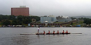
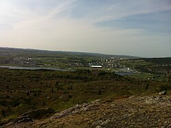
Quidi Vidi Lake is a 1,600 m (1 mi) long body of water located at the east end of the city of St. John's, Newfoundland, Canada. Local people commonly pronounce its name as kiddy viddy. Water flows into the lake from the Rennies and Virginia Rivers, along with smaller streams, and then into the sea through Quidi Vidi harbour. The lake has a long history of hosting sporting events, including the annual Royal St. John's Regatta, said to be the oldest continuous sporting event still held in North America. The former Pepperrell Air Force Base was located on the north shore of the lake and a military presence continues in the form of Canadian Forces Station St. John's ). The South shore of the Lake has a number of residential and apartment complexes. A number of cultural events are held at Lakeside.
Virginia Park is a neighbourhood in the northeast end of St. John's, Newfoundland and Labrador.
The city of St. John's is made up of many neighbourhoods. Neighbourhoods such as Georgestown and Rabbittown have long histories in the city and were among the first residential neighbourhoods to be built, while other neighbourhoods such as the Goulds and Kilbride are former communities that have been amalgamated with St. John's.

Mallard Cottage is a heritage-designated building located within Quidi Vidi Village in the City of St.John's, Newfoundland and Labrador. The cottage is a one-and-a-half-stories with a hipped roof and central chimney. The architecture is an example of early 19th century vernacular style patterned on Irish thatched-roofed cottages. Though the exact date of construction cannot be confirmed, based on evidence from construction techniques, architectural style, and oral history the date for its construction are placed between 1820 and 1840, making it one of the oldest residential structures in St. John's. Two other buildings in St.John's of the same style are Anderson House, built 1804–1805, and Martin McNamara House, exact construction date unknown. These three structures are the best preserved examples of late 18th and early 19th century architecture in St.John's.