
Navigation is a field of study that focuses on the process of monitoring and controlling the movement of a craft or vehicle from one place to another. The field of navigation includes four general categories: land navigation, marine navigation, aeronautic navigation, and space navigation.

Celestial navigation, also known as astronavigation, is the ancient and modern practice of position fixing that enables a navigator to transition through a space without having to rely on estimated calculations, or dead reckoning, to know their position. Celestial navigation uses "sights", or angular measurements taken between a celestial body and the visible horizon. The Sun is most commonly used, but navigators can also use the Moon, a planet, Polaris, or one of 57 other navigational stars whose coordinates are tabulated in the nautical almanac and air almanacs.

A non-directional (radio) beacon (NDB) is a radio transmitter at a known location, used as an aviation or marine navigational aid. As the name implies, the signal transmitted does not include inherent directional information, in contrast to other navigational aids such as low frequency radio range, VHF omnidirectional range (VOR) and TACAN. NDB signals follow the curvature of the Earth, so they can be received at much greater distances at lower altitudes, a major advantage over VOR. However, NDB signals are also affected more by atmospheric conditions, mountainous terrain, coastal refraction and electrical storms, particularly at long range.

Very High Frequency (VHF) Omni-Directional Range (VOR) is a type of short-range radio navigation system for aircraft, enabling aircraft with a receiving unit to determine its position and stay on course by receiving radio signals transmitted by a network of fixed ground radio beacons. It uses frequencies in the very high frequency (VHF) band from 108.00 to 117.95 MHz. Developed in the United States beginning in 1937 and deployed by 1946, VOR is the standard air navigational system in the world, used by both commercial and general aviation. By 2000 there were about 3,000 VOR stations around the world including 1,033 in the US, reduced to 967 by 2013 with more stations being decommissioned with the widespread adoption of GPS.

In position fixing navigation, a position fix (PF) or simply a fix is a position derived from measuring in relation to external reference points.

An electronic flight instrument system (EFIS) is a flight deck instrument display system that displays flight data electronically rather than electromechanically. An EFIS normally consists of a primary flight display (PFD), multi-function display (MFD), and an engine indicating and crew alerting system (EICAS) display. Early EFIS models used cathode ray tube (CRT) displays, but liquid crystal displays (LCD) are now more common. The complex electromechanical attitude director indicator (ADI) and horizontal situation indicator (HSI) were the first candidates for replacement by EFIS. Now, however, few flight deck instruments cannot be replaced by an electronic display.

A manual is a musical keyboard designed to be played with the hands, on an instrument such as a pipe organ, harpsichord, clavichord, electronic organ, or synthesizer. The term "manual" is used with regard to any hand keyboard on these instruments to distinguish it from the pedalboard, which is a keyboard that the organist plays with their feet. It is proper to use "manual" rather than "keyboard", then, when referring to the hand keyboards on any instrument that has a pedalboard.

A logbook is a record of important events in the management, operation, and navigation of a ship. It is essential to traditional navigation, and must be filled in at least daily.

In aviation, an instrument approach or instrument approach procedure (IAP) is a series of predetermined maneuvers for the orderly transfer of an aircraft under instrument flight conditions from the beginning of the initial approach to a landing or to a point from which a landing may be made visually. These approaches are approved in the European Union by EASA and the respective country authorities and in the United States by the FAA or the United States Department of Defense for the military. The ICAO defines an instrument approach as a series of predetermined maneuvers by reference to flight instruments with specific protection from obstacles from the initial approach fix, or where applicable, from the beginning of a defined arrival route to a point from which a landing can be completed and thereafter, if landing is not completed, to a position at which holding or enroute obstacle clearance criteria apply.

A marine radar with automatic radar plotting aid (ARPA) capability can create tracks using radar contacts. The system can calculate the tracked object's course, speed and closest point of approach (CPA), thereby knowing if there is a danger of collision with the other ship or landmass.

A flight management system (FMS) is a fundamental component of a modern airliner's avionics. An FMS is a specialized computer system that automates a wide variety of in-flight tasks, reducing the workload on the flight crew to the point that modern civilian aircraft no longer carry flight engineers or navigators. A primary function is in-flight management of the flight plan. Using various sensors to determine the aircraft's position, the FMS can guide the aircraft along the flight plan. From the cockpit, the FMS is normally controlled through a Control Display Unit (CDU) which incorporates a small screen and keyboard or touchscreen. The FMS sends the flight plan for display to the Electronic Flight Instrument System (EFIS), Navigation Display (ND), or Multifunction Display (MFD). The FMS can be summarised as being a dual system consisting of the Flight Management Computer (FMC), CDU and a cross talk bus.
In music, a chorus effect occurs when individual sounds with approximately the same time, and very similar pitches converge and are perceived as one. While similar sounds coming from multiple sources can occur naturally, as in the case of a choir or string orchestra, it can also be simulated using an electronic effects unit or signal processing device.
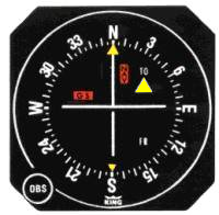
A course deviation indicator (CDI) is an avionics instrument used in aircraft navigation to determine an aircraft's lateral position in relation to a course. If the location of the aircraft is to the left of course, the needle deflects to the right, and vice versa.

The Yeoman Plotter was a plotter used on ships and boats to transfer GPS coordinates or RADAR echo locations onto a paper navigation chart and to read coordinates from the chart. It was manufactured from 1985 to 2014/2015 and was an intermediary step between traditional paper chart navigation and full electronic chart displays. It was easy to understand for people that were accustomed to paper charts and much cheaper than electronic chart displays available at the time. The continuing fall in prices of electronic chart displays, their increase in functionality such as radar overlay and the advent of cheap tablets eventually made the Yeoman plotter uncompetitive.
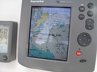
A Chartplotter is a device used in marine navigation that integrates GPS data with an electronic navigational chart (ENC).

Operations Specialist is a United States Navy and United States Coast Guard occupational rating. It is a sea duty-intensive rating in the Navy while the majority of Coast Guard OS's are at ashore Command Centers.
Marine and aviation radar systems can provide very useful navigation information in a variety of situations. When a vessel is within radar range of land or special radar aids to navigation, the navigator can take distances and angular bearings to charted objects and use these to establish arcs of position and lines of position on a chart. A fix consisting of only radar information is called a radar fix.
Stowe Marine is a developer and manufacturer of advanced instrumentation systems for racing and cruising sailing yachts.

Marine radars are X band or S band radars on ships, used to detect other ships and land obstacles, to provide bearing and distance for collision avoidance and navigation at sea. They are electronic navigation instruments that use a rotating antenna to sweep a narrow beam of microwaves around the water surface surrounding the ship to the horizon, detecting targets by microwaves reflected from them, displaying a picture of the ship's surroundings on a display screen. A Radar has a flat antenna that spins. It emits a signal, then listens back for that signal. The signal bounces back at varying times based on what it may be bouncing off of.
