
Navigation is a field of study that focuses on the process of monitoring and controlling the movement of a craft or vehicle from one place to another. The field of navigation includes four general categories: land navigation, marine navigation, aeronautic navigation, and space navigation.

Celestial navigation, also known as astronavigation, is the practice of position fixing using stars and other celestial bodies that enables a navigator to accurately determine their actual current physical position in space or on the surface of the Earth without relying solely on estimated positional calculations, commonly known as "dead reckoning." Celestial navigation is performed without using satellite navigation or other similar modern electronic or digital positioning means.

Radio navigation or radionavigation is the application of radio frequencies to determine a position of an object on the Earth, either the vessel or an obstruction. Like radiolocation, it is a type of radiodetermination.
A waypoint is an intermediate point or place on a route or line of travel, a stopping point or point at which course is changed, the first use of the term tracing to 1880. In modern terms, it most often refers to coordinates which specify one's position on the globe at the end of each "leg" (stage) of an air flight or sea passage, the generation and checking of which are generally done computationally.

A nautical chart or hydrographic chart is a graphic representation of a sea region or water body and adjacent coasts or banks. Depending on the scale of the chart, it may show depths of water (bathymetry) and heights of land (topography), natural features of the seabed, details of the coastline, navigational hazards, locations of natural and human-made aids to navigation, information on tides and currents, local details of the Earth's magnetic field, and human-made structures such as harbours, buildings, and bridges. Nautical charts are essential tools for marine navigation; many countries require vessels, especially commercial ships, to carry them. Nautical charting may take the form of charts printed on paper or computerized electronic navigational charts. Recent technologies have made available paper charts which are printed "on demand" with cartographic data that has been downloaded to the commercial printing company as recently as the night before printing. With each daily download, critical data such as Local Notices to Mariners are added to the on-demand chart files so that these charts are up to date at the time of printing.
Piloting or pilotage is the process of navigating on water or in the air using fixed points of reference on the sea or on land, usually with reference to a nautical chart or aeronautical chart to obtain a fix of the position of the vessel or aircraft with respect to a desired course or location. Horizontal fixes of position from known reference points may be obtained by sight or by radar. Vertical position may be obtained by depth sounder to determine depth of the water body below a vessel or by altimeter to determine an aircraft's altitude, from which its distance above the ground can be deduced. Piloting a vessel is usually practiced close to shore or on inland waterways. Pilotage of an aircraft is practiced under visual meteorological conditions for flight.

A navigator is the person on board a ship or aircraft responsible for its navigation. The navigator's primary responsibility is to be aware of ship or aircraft position at all times. Responsibilities include planning the journey, advising the ship's captain or aircraft commander of estimated timing to destinations while en route, and ensuring hazards are avoided. The navigator is in charge of maintaining the aircraft or ship's nautical charts, nautical publications, and navigational equipment, and they generally have responsibility for meteorological equipment and communications. With the advent of satellite navigation, the effort required to accurately determine one's position has decreased by orders of magnitude, so the entire field has experienced a revolutionary transition since the 1990s with traditional navigation tasks, like performing celestial navigation, being used less frequently. Using multiple independent position fix methods without solely relying on electronic systems subject to failure helps the navigator detect errors. Professional mariners are still proficient in traditional piloting and celestial navigation.
Navigational instruments are instruments used by nautical navigators and pilots as tools of their trade. The purpose of navigation is to ascertain the present position and to determine the speed, direction, etc. to arrive at the port or point of destination.

Diver navigation, termed "underwater navigation" by scuba divers, is a set of techniques—including observing natural features, the use of a compass, and surface observations—that divers use to navigate underwater. Free-divers do not spend enough time underwater for navigation to be important, and surface supplied divers are limited in the distance they can travel by the length of their umbilicals and are usually directed from the surface control point. On those occasions when they need to navigate they can use the same methods used by scuba divers.
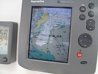
A Chartplotter is a device used in marine navigation that integrates GPS data with an electronic navigational chart (ENC).

Operations Specialist is a United States Navy and United States Coast Guard occupational rating. It is a sea duty-intensive rating in the Navy while most of Coast Guard OS's are at ashore Command Centers.

Radar navigation is the utilization of marine and aviation radar systems for vessel and aircraft navigation. When a craft is within radar range of land or special radar aids to navigation, the navigator can take distances and angular bearings to charted objects and use these to establish arcs of position and lines of position on a chart. A fix consisting of only radar information is called a radar fix.

Submarine navigation underwater requires special skills and technologies not needed by surface ships. The challenges of underwater navigation have become more important as submarines spend more time underwater, travelling greater distances and at higher speed. Military submarines travel underwater in an environment of total darkness with neither windows nor lights. Operating in stealth mode, they cannot use their active sonar systems to ping ahead for underwater hazards such as undersea mountains, drilling rigs or other submarines. Surfacing to obtain navigational fixes is precluded by pervasive anti-submarine warfare detection systems such as radar and satellite surveillance. Antenna masts and antenna-equipped periscopes can be raised to obtain navigational signals but in areas of heavy surveillance, only for a few seconds or minutes; current radar technology can detect even a slender periscope while submarine shadows may be plainly visible from the air.
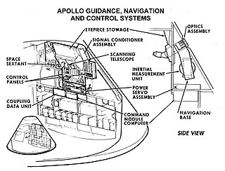
Guidance, navigation and control is a branch of engineering dealing with the design of systems to control the movement of vehicles, especially, automobiles, ships, aircraft, and spacecraft. In many cases these functions can be performed by trained humans. However, because of the speed of, for example, a rocket's dynamics, human reaction time is too slow to control this movement. Therefore, systems—now almost exclusively digital electronic—are used for such control. Even in cases where humans can perform these functions, it is often the case that GNC systems provide benefits such as alleviating operator work load, smoothing turbulence, fuel savings, etc. In addition, sophisticated applications of GNC enable automatic or remote control.
Position resection and intersection are methods for determining an unknown geographic position by measuring angles with respect to known positions. In resection, the one point with unknown coordinates is occupied and sightings are taken to the known points; in intersection, the two points with known coordinates are occupied and sightings are taken to the unknown point.

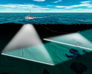
A short baseline (SBL) acoustic positioning system is one of three broad classes of underwater acoustic positioning systems that are used to track underwater vehicles and divers. The other two classes are ultra short baseline systems (USBL) and long baseline systems (LBL). Like USBL systems, SBL systems do not require any seafloor mounted transponders or equipment and are thus suitable for tracking underwater targets from boats or ships that are either anchored or under way. However, unlike USBL systems, which offer a fixed accuracy, SBL positioning accuracy improves with transducer spacing. Thus, where space permits, such as when operating from larger vessels or a dock, the SBL system can achieve a precision and position robustness that is similar to that of sea floor mounted LBL systems, making the system suitable for high-accuracy survey work. When operating from a smaller vessel where transducer spacing is limited, the SBL system will exhibit reduced precision.

Marine radars are X band or S band radars on ships, used to detect other ships and land obstacles, to provide bearing and distance for collision avoidance and navigation at sea. They are electronic navigation instruments that use a rotating antenna to sweep a narrow beam of microwaves around the water surface surrounding the ship to the horizon, detecting targets by microwaves reflected from them, generating a picture of the ship's surroundings on a display screen.
Enhanced radar positioning is a proposal for a position fixing system in maritime navigation, based on radar navigation. It is the automation of the process of determining own position by means of radar fixing, using a multitude of objects with known position as reference.

Geopositioning is the process of determining or estimating the geographic position of an object.
An underwater survey is a survey performed in an underwater environment or conducted remotely on an underwater object or region. Survey can have several meanings. The word originates in Medieval Latin with meanings of looking over and detailed study of a subject. One meaning is the accurate measurement of a geographical region, usually with the intention of plotting the positions of features as a scale map of the region. This meaning is often used in scientific contexts, and also in civil engineering and mineral extraction. Another meaning, often used in a civil, structural, or marine engineering context, is the inspection of a structure or vessel to compare actual condition with the specified nominal condition, usually with the purpose of reporting on the actual condition and compliance with, or deviations from, the nominal condition, for quality control, damage assessment, valuation, insurance, maintenance, and similar purposes. In other contexts it can mean inspection of a region to establish presence and distribution of specified content, such as living organisms, either to establish a baseline, or to compare with a baseline.
