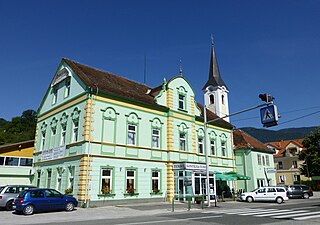
Podgorje is a settlement in the City Municipality of Slovenj Gradec in northern Slovenia. The area was traditionally part of Styria. The entire municipality is now included in the Carinthia Statistical Region.

Podgorje is a settlement in the Municipality of Velenje in northern Slovenia. It lies in the foothills of the Ložnica Hills west of the town of Velenje, above the regional road from Velenje to Šoštanj. The area was traditionally part of Styria. The entire municipality is now included in the Savinja Statistical Region.

Podgorje pri Pišecah is a settlement in the hills west of Bizeljsko in the Municipality of Brežice in eastern Slovenia. The area was traditionally part of Styria. It is now included with the rest of the municipality in the Lower Sava Statistical Region.

Dol pod Gojko is a settlement in the Municipality of Vojnik in eastern Slovenia. The area was traditionally part of the Styria region. It is now included with the rest of the municipality in the Savinja Statistical Region.

Črešnjevec is a small settlement in the Municipality of Vojnik in eastern Slovenia. It lies in the hills east of Vojnik. The area was traditionally part of Styria. It is now included with the rest of the municipality in the Savinja Statistical Region.

Globoče is a settlement in the Municipality of Vojnik in eastern Slovenia. It lies just south of Frankolovo off the main road from Vojnik towards Slovenske Konjice. The area was traditionally part of Styria. It is now included with the rest of the municipality in the Savinja Statistical Region.

Homec is a settlement in the Municipality of Vojnik in eastern Slovenia. The area was traditionally part of Styria. It is now included with the rest of the municipality in the Savinja Statistical Region.

Hrastnik is a small settlement in the hills east of Vojnik in eastern Slovenia. The area was traditionally part of the Styria region. It is now included with the rest of the Municipality of Vojnik in the Savinja Statistical Region.

Hrenova is a settlement in the Municipality of Vojnik in eastern Slovenia. The area was traditionally part of the Styria region. It is now included with the rest of the municipality in the Savinja Statistical Region.

Kladnart is a small settlement in the Municipality of Vojnik in eastern Slovenia. It has a relatively remote location in the hills east of Vojnik and a permanent population of only six. The area was traditionally part of the Styria region. It is now included with the rest of the municipality in the Savinja Statistical Region.

Konjsko is a settlement in the Municipality of Vojnik in eastern Slovenia. It lies in the hills west of Vojnik. The area was traditionally part of the Styria region and is now included in the Savinja Statistical Region.

Lešje is a settlement in the Municipality of Vojnik in eastern Slovenia. It lies just east of Arclin next to Lake Šmartno. The area was traditionally part of the Styria region. It is now included with the rest of the municipality in the Savinja Statistical Region.

Male Dole is a settlement in the Municipality of Vojnik in eastern Slovenia. The area is part of the traditional region of Styria. It is now included with the rest of the municipality in the Savinja Statistical Region.

Pristava is a small settlement in the Municipality of Vojnik in eastern Slovenia. It lies in the valley of Ložnica Creek southeast of Vojnik. The area was traditionally part of the Styria region. It is now included in the Savinja Statistical Region.

Razgorce is a small settlement in the Municipality of Vojnik in eastern Slovenia. It lies in the hills northeast of Vojnik. The area was traditionally part of the Styria region. It is now included with the rest of the municipality in the Savinja Statistical Region.

Selce is a settlement in the hills north of Nova Cerkev in the Municipality of Vojnik in eastern Slovenia. The area is part of the traditional region of Styria. It is now included with the rest of the municipality in the Savinja Statistical Region.

Stražica is a settlement in the Municipality of Vojnik in eastern Slovenia. It lies in the hills northwest of Frankolovo off the main road from Vojnik to Slovenske Konjice. The area is part of the traditional region of Styria. It is now included with the rest of the municipality in the Savinja Statistical Region.

Podgorje pri Letušu is a settlement in the Municipality of Braslovče in northern Slovenia. It lies on the right bank of the Savinja River west of Letuš under the Dobrovlje Hills. Traditionally the area was part of the Styria region. The municipality is now included in the Savinja Statistical Region.

Podgorica pri Šmarju is a small settlement just north of Šmarje–Sap in the Municipality of Grosuplje in central Slovenia. The area is part of the historical region of Lower Carniola and is now included in the Central Slovenia Statistical Region.

Podgorje ob Sevnični is a dispersed settlement in the hills north of Sevnica in east-central Slovenia. The area is part of the historical region of Styria. The Municipality of Sevnica is now included in the Lower Sava Statistical Region.


