The Kamnik–Savinja Alps are a mountain range of the Southern Limestone Alps. They lie in northern Slovenia, except for the northernmost part, which lies in Austria.

Magdalensberg is a market town in the district of Klagenfurt-Land in Carinthia in Austria.

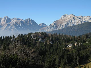
Golica is a peak in the Western Karawanks, on the border between Slovenia and Austria, above the Slovene town of Jesenice. It is known mainly for its fields of wild white narcissi, swathes of which cover Golica and surrounding pastures in late April and early May. This marks the beginning of a popular time for mountaineers to visit, extending through the end of summer. The slopes provide great views of the Julian Alps and Austrian Carinthia; the Ljubljana Basin can be seen from the summit on clear days.
Podgorje is a village in the City Municipality of Koper in the Littoral region of Slovenia on the border with Croatia.
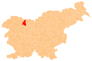
Bela Peč is a small dispersed settlement in the Municipality of Kamnik in the Upper Carniola region of Slovenia.

Poreber is a dispersed settlement in the Municipality of Kamnik in the Upper Carniola region of Slovenia.
Krašnji Vrh is a small village in the Municipality of Metlika in the White Carniola area of southeastern Slovenia, right on the border with Croatia. The area is part of the traditional region of Lower Carniola and is now included in the Southeast Slovenia Statistical Region.
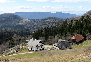
Podplanina is a small settlement in the Municipality of Loški Potok in southern Slovenia, next to the border with Croatia. The source of the Čabranka River lies just west of the village. The area is part of the traditional region of Lower Carniola and is now included in the Southeast Slovenia Statistical Region. It stands on terraces above the Čabranka River on steep slopes below Trava Peak. The settlement consists of a number of hamlets and individual houses. The core of the settlement is in the hamlet of Pri Kapelici.
Otavice is a village southeast of the town of Ribnica in southern Slovenia. The area is part of the traditional region of Lower Carniola and is now included in the Southeast Slovenia Statistical Region. It includes the hamlet of Ograda southeast of the main settlement.

Podgrad is a settlement east of the capital Ljubljana in central Slovenia. It belongs to the City Municipality of Ljubljana. It lies on the right bank of the Ljubljanica River at the entrance into the Besnica Valley. The Ljubljanica in turn flows into the Sava immediately northeast of the settlement core. The railway line from Ljubljana to Zidani Most runs through the settlement. The area was part of the traditional region of Lower Carniola and is now included with the rest of the municipality in the Central Slovenia Statistical Region.

Podmolnik is a settlement in the City Municipality of Ljubljana in central Slovenia. It was part of the traditional region of Lower Carniola and is now included with the rest of the municipality in the Central Slovenia Statistical Region.

Rašica is a small village in the hills above Srednje Gameljne north of the capital Ljubljana in central Slovenia. It belongs to the City Municipality of Ljubljana. It was part of the traditional region of Upper Carniola and is now included with the rest of the municipality in the Central Slovenia Statistical Region.

Podgora is a village in the Municipality of Dobrepolje in Slovenia. The area is part of the historical region of Lower Carniola. The municipality is now included in the Central Slovenia Statistical Region.

Planina is a village in the Municipality of Semič in Slovenia. It lies on the southern slopes of Mount Mirna in the southern part of Kočevje Rog. It was inhabited by Gottschee Germans that were expelled in 1941 during the Second World War. The area is part of the historical region of Lower Carniola. The municipality is now included in the Southeast Slovenia Statistical Region.

Podgorica pri Šmarju is a small settlement just north of Šmarje–Sap in the Municipality of Grosuplje in central Slovenia. The area is part of the historical region of Lower Carniola and is now included in the Central Slovenia Statistical Region.

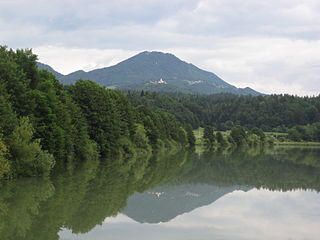
Mount Saint Mary, originally known as Holm, is an inselberg in the north of Ljubljana, the capital of Slovenia. The mountain is part of the city's Šmarna Gora District. It is the highest hill in the city and a popular hiking destination.
Lisca is a 948 m hill in the eastern part of the Sava Hills in southeastern Slovenia, northwest of Sevnica, north of the Sava, and south of Gračnica Creek. The hill offers a superb view. It is the most frequently visited hiking destination in the Sava Hills.

Rožna Dolina is a formerly independent settlement in the southwest part of the capital Ljubljana in central Slovenia. It was part of the traditional region of Upper Carniola and is now included with the rest of the municipality in the Central Slovenia Statistical Region.

Podgora is a former settlement in central Slovenia in the northwest part of the capital Ljubljana. It belongs to the Šentvid District of the City Municipality of Ljubljana. It was part of the traditional region of Upper Carniola and is now included with the rest of the municipality in the Central Slovenia Statistical Region.

Podborst is a formerly independent settlement in the northern part of the capital Ljubljana in central Slovenia. It was part of the traditional region of Upper Carniola and is now included with the rest of the municipality in the Central Slovenia Statistical Region.