
A volcano is a rupture in the crust of a planetary-mass object, such as Earth, that allows hot lava, volcanic ash, and gases to escape from a magma chamber below the surface.

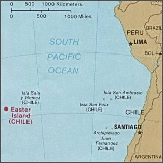
Easter Island is an island and special territory of Chile in the southeastern Pacific Ocean, at the southeasternmost point of the Polynesian Triangle in Oceania. The island is most famous for its nearly 1,000 extant monumental statues, called moai, which were created by the early Rapa Nui people. In 1995, UNESCO named Easter Island a World Heritage Site, with much of the island protected within Rapa Nui National Park.

Rano Raraku is a volcanic crater formed of consolidated volcanic ash, or tuff, and located on the lower slopes of Terevaka in the Rapa Nui National Park on Easter Island in Chile. It was a quarry for about 500 years until the early eighteenth century, and supplied the stone from which about 95% of the island's known monolithic sculptures (moai) were carved. Rano Raraku is a visual record of moai design vocabulary and technological innovation, where 887 moai remain. Rano Raraku is in the World Heritage Site of Rapa Nui National Park and gives its name to one of the seven sections of the park.

Isla Salas y Gómez, also known as Isla Sala y Gómez, is a small uninhabited Chilean island in the Pacific Ocean. It is sometimes considered the easternmost point in the Polynesian Triangle.
Rapa Nui National Park is a national park and UNESCO World Heritage Site located on Easter Island, Chile. Rapa Nui is the Polynesian name of Easter Island; its Spanish name is Isla de Pascua. The island is located in the southeastern Pacific Ocean, at the southeastern extremity of the Polynesian Triangle. The island was taken over by Chile in 1888. Its fame and World Heritage status arise from the 887 extant stone statues known by the name "moai", whose creation is attributed to the early Rapa Nui people who inhabited the island starting between 300 and 1200 AD. Much of the island has been declared as Rapa Nui National Park which, on 22 March 1996, UNESCO designated a World Heritage Site under cultural criteria (i), (iii), & (v). The Rapa Nui National Park is now under the administrative control of the Ma´u Henua Polynesian Indigenous Community, which is the first autonomous institute on the island. The indigenous Rapa Nui people have regained authority over their ancestral lands and are in charge of the management, preservation and protection of their patrimony. On the first of December 2017, the ex-President Michelle Bachelet returned ancestral lands in the form of the Rapa Nui National Park to the indigenous people. For the first time in history, the revenue generated by the National Park is invested in the island and used to conserve the natural heritage.

Motu Iti, or Little island in the Rapa Nui language, is a small uninhabited islet near Motu Nui, about a mile from Rano Kau on the south western corner of Easter Island, a Chilean island in the Pacific. It has a land area of 1.6 hectares, which makes it the second largest of the five satellite islands of Easter Island, after Motu Nui.
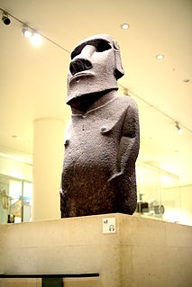
Hoa Hakananai'a is a moai, a statue from Easter Island. It was taken from Orongo, Easter Island in 1868 by the crew of a British ship and is now in the British Museum in London.

ꞌOrongo is a stone village and ceremonial center at the southwestern tip of Rapa Nui. It consists of a collection of low, sod-covered, windowless, round-walled buildings with even lower doors positioned on the high south-westerly tip of the large volcanic caldera called Rano Kau. Below Orongo on one side a 300-meter barren cliff face drops down to the ocean; on the other, a more gentle but still very steep grassy slope leads down to a freshwater marsh inside the high caldera.

Anakena is a white coral sand beach in Rapa Nui National Park on Rapa Nui, a Chilean island in the Pacific Ocean. Anakena has two ahus; Ahu-Ature has a single moai and Ahu Nao-Nao has seven, two of which have deteriorated. It also has a palm grove and a car park.

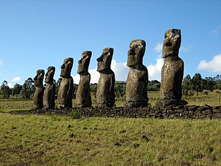
Ahu Tongariki is the largest ahu on Easter Island. Its moais were toppled during the island's civil wars, and in the twentieth century the ahu was swept inland by a tsunami. It has since been restored and has fifteen moai, including one that weighs eighty-six tonnes, the heaviest ever erected on the island. Ahu Tongariki is one kilometer from Rano Raraku and Poike in the Hotu-iti area of Rapa Nui National Park. All the moai here face sunset during the winter solstice.

Rano Kau is a 324 m (1,063 ft) tall dormant volcano that forms the southwestern headland of Easter Island, a Chilean island in the Pacific Ocean. It was formed of basaltic lava flows in the Pleistocene with its youngest rocks dated at between 150,000 and 210,000 years ago.

Ma′unga Terevaka is the largest, tallest and youngest of three main extinct volcanoes that form Easter Island. Several smaller volcanic cones and craters dot its slopes, including a crater hosting one of the island's three lakes, Rano Aroi.

Ahu Akivi is a particular sacred place on the Chilean island of Rapa Nui, looking out towards the Pacific Ocean. The site has seven moai, all of equal shape and size, and is also known as a celestial observatory that was set up around the 16th century. The site is located inland, rather than along the coast. Moai statues were considered by the early people of Rapa Nui as their ancestors or Tupuna that were believed to be the reincarnation of important kings or leaders of their clans. The Moais were erected to protect and bring prosperity to their clan and village.

The Moai Seamount is a submarine volcano, the second most westerly in the Easter Seamount Chain or Sala y Gómez ridge. It is east of Pukao seamount and west of Easter Island. It rises over 2,500 metres from the ocean floor to within a few hundred metres of the sea surface. The Moai seamount is fairly young, having developed in the last few hundred thousand years as the Nazca Plate floats over the Easter hotspot.
The Pukao Seamount is a submarine volcano, the most westerly in the Easter Seamount Chain or Sala y Gómez ridge. To the east are Moai (seamount) and then Easter Island. It rises over 2,500 metres from the ocean floor to within a few hundred metres of the sea surface. The Pukao Seamount is fairly young, and believed to have developed in the last few hundred thousand years as the Nazca Plate floats over the Easter hotspot.

The Easter hotspot is a volcanic hotspot located in the southeastern Pacific Ocean. The hotspot created the Sala y Gómez Ridge which includes Easter Island, Salas y Gómez Island and the Pukao Seamount which is at the ridge's young western edge. Easter Island, because of its tectonomagmatic features, represents an end-member type of hotspot volcano in this chain.
Geologically one of the youngest inhabited territories on Earth, Easter Island, located in the mid-Pacific Ocean, was, for most of its history, one of the most isolated. Its inhabitants, the Rapa Nui, have endured famines, epidemics of disease and cannibalism, civil war, environmental collapse, slave raids, various colonial contacts, and have seen their population crash on more than one occasion. The ensuing cultural legacy has brought the island notoriety out of proportion to the number of its inhabitants.

The geology of Chile is a characterized by processes linked to subduction such as volcanism, earthquakes and orogeny. The buildings blocks of Chile's geology assembled during the Paleozoic Era. Chile was by then the southwestern margin of the supercontinent Gondwana. In the Jurassic Gondwana began to split and the ongoing period of crustal deformation and mountain building known as the Andean orogeny began. In the Late Cenozoic Chile definitely separated from Antarctica, the Andes experienced a great rise accomplained by a cooling climate and the onset of glaciations.

The Tahai Ceremonial Complex is an archaeological site on Rapa Nui in Chilean Polynesia. Restored in 1974 by American archaeologist William Mulloy, Tahai comprises three principal ahu from north to south: Ko Te Riku, Tahai, and Vai Ure. Visible in the distance from Tahai are two restored ahu at Hanga Kio'e, projects that Mulloy undertook in 1972. Like other Mulloy restoration projects at Ahu Akivi, the ceremonial village of Orongo and Vinapu, the ceremonial center at Tahai now constitutes an integral part of the Rapa Nui National Park, designated by UNESCO as a World Heritage site.

