
Mathews County is a county located in the U.S. state of Virginia. As of the 2010 census, the population was 8,978. Its county seat is Mathews.

Hampton is an independent city in the Commonwealth of Virginia in the United States. As of the 2010 census, the population was 137,436.

The Virginia Peninsula is a peninsula in southeast Virginia, USA, bounded by the York River, James River, Hampton Roads and Chesapeake Bay. It is sometimes known as the Lower Peninsula to distinguish it from two other peninsulas to the north, the Middle Peninsula and the Northern Neck.

Mammary intercourse is a sex act, performed as either foreplay or as non-penetrative sex, that involves the stimulation of the male penis by the female breasts and vice versa.

Fort Monroe is a decommissioned military installation in Hampton, Virginia at Old Point Comfort, the southern tip of the Virginia Peninsula, United States. Along with Fort Wool, Fort Monroe originally guarded the navigation channel between the Chesapeake Bay and Hampton Roads—the natural roadstead at the confluence of the Elizabeth, the Nansemond and the James rivers. Until disarmament in 1946, the areas protected by the fort were the entire Chesapeake Bay and Potomac River regions, including the water approaches to the cities of Washington, D.C. and Baltimore, Maryland, along with important shipyards and naval bases in the Hampton Roads area. Surrounded by a moat, the six-sided bastion fort is the largest fort by area ever built in the United States.
Old Point Comfort is a point of land located in the independent city of Hampton, Virginia. Previously known as Point Comfort, it lies at the extreme tip of the Virginia Peninsula at the mouth of Hampton Roads in the United States.
John Ratcliffe was captain of the Discovery, one of three ships that sailed from England on 19 December 1606 to Virginia to found a colony, arriving 26 April 1607. He later became the second president of the colony which later became Jamestown. He was killed by the Pamunkey Native Americans when he was going to trade with them in 1609.
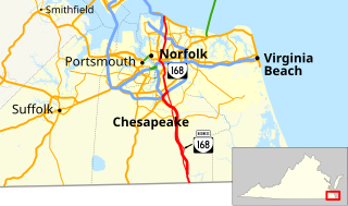
State Route 168 is a primary state highway in the South Hampton Roads region of the U.S. state of Virginia. It runs from the border with North Carolina through the independent cities of Chesapeake and Norfolk where it ends in the Ocean View area near the Hampton Roads Bridge-Tunnel.

The Little Creek-Cape Charles Ferry was a passenger ferry service operating across the mouth of the Chesapeake Bay from the 1930s until 1964. Known also as the Princess Anne-Kiptopeke Beach Ferry or Little Creek-Kiptopeke Beach Ferry, the service connected Virginia Beach, Virginia with Cape Charles on the Eastern Shore of Virginia.
Comfort is the physical and psychological sense of ease.
Elzy Burroughs (1771/77–1825) was an American stonemason, engineer, lighthouse builder and keeper.
New Point Comfort is a point of land located in Mathews County at the tip of Virginia's Middle Peninsula in the lower Chesapeake Bay in the United States. It is the site of the New Point Comfort Natural Area Preserve and the New Point Comfort Light.

State Route 14 is a primary state highway in the U.S. state of Virginia. The state highway runs 71.10 miles (114.42 km) from U.S. Route 360 in St. Stephens Church east to a cul-de-sac in Bayside. SR 14 is the primary highway of King and Queen and Mathews counties and the main east–west highway of Gloucester County; the highway connects the namesake county seats of all three counties.

New Point Comfort Light is a lighthouse in the Virginia portion of the Chesapeake Bay, United States, off the tip of the Middle Peninsula. Finished in 1804, it is the third-oldest surviving light in the bay, and the tenth-oldest in the United States.

Old Point Comfort Light is a lighthouse located on the grounds of Fort Monroe in the Virginia portion of the Chesapeake Bay. It is the second oldest light in the bay and the oldest still in use. The lighthouse is owned and maintained by the U.S. Coast Guard and is listed on the National Register of Historic Places.
Captain Samuel Mathews was a Virginia planter, political figure, and the father of Governor Samuel Mathews.

New Point Comfort Natural Area Preserve is a 105-acre (42 ha) Natural Area Preserve located in Mathews County, Virginia. The point is situated on Chesapeake Bay along the Atlantic Flyway, and consequently provides habitat for nesting and breeding birds, both during the migration season and at other times throughout the year; among the birds that may be found there is the rare least tern. The northeastern beach tiger beetle, listed as threatened in the United States, also makes its home in portions of the preserve.

Comfort is a census-designated place (CDP) in Boone County, West Virginia, United States. Comfort is located on West Virginia Route 3 12 miles (19 km) northeast of Madison. Comfort has a post office with ZIP code 25049. As of the 2010 census, its population is 306. Comfort is the home of Sherman Elementary School.
The Sheepskin Trail is a non-motorized rail-trail in Fayette County, Pennsylvania. It is planned to eventually link the Great Allegheny Passage trail system near Dunbar to the Mon River Trail system at the Pennsylvania/West Virginia state line near Point Marion. Currently, due to funding restrictions, the trail is only opened for 2.1 miles (3.4 km) from the Great Allegheny Passage junction to the Dunbar town center, where there is parking and a comfort station available for public use.


