Point Comfort, Texas

Last updated

Point Comfort, Texas
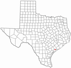
TXMap-doton-PointComfort.PNG
Location of Point Comfort, Texas
Calhoun County PortComfort.svg
Coordinates: 28°40′17″N96°33′33″W / 28.67139°N 96.55917°W / 28.67139; -96.55917
Country United States
State Texas
County Calhoun
Area
[1]
  Total1.32 sq mi (3.41 km2)
  Land1.31 sq mi (3.41 km2)
  Water0.00 sq mi (0.00 km2)
Elevation
[2]
20 ft (6 m)
Population
 (2010)
  Total737
  Estimate 
(2019) [3]
677
  Density514.83/sq mi (198.79/km2)
Time zone UTC-6 (Central (CST))
  Summer (DST) UTC-5 (CDT)
ZIP code
77978
Area code 361
FIPS code 48-58568 [4]
GNIS feature ID2411451 [2]

Point Comfort is a city in Calhoun County, Texas, United States. It is a part of the Victoria, Texas Metropolitan Statistical Area. The population was 737 at the 2010 census. [5]

Contents

Geography

Point Comfort is located in northeastern Calhoun County on the east side of Lavaca Bay. Texas State Highway 35 passes through the community, leading southwest across the bay 7 miles (11 km) to Port Lavaca, the Calhoun County seat, and east 23 miles (37 km) to Palacios.

According to the United States Census Bureau, Point Comfort has a total area of 1.3 square miles (3.4 km2), all land. [5]

Climate

The climate in this area is characterized by hot, humid summers and generally mild to cool winters. According to the Köppen Climate Classification system, Point Comfort has a humid subtropical climate, abbreviated "Cfa" on climate maps.

Climate data for Point Comfort, Texas, 1991–2020 normals, extremes 1957–present
MonthJanFebMarAprMayJunJulAugSepOctNovDecYear
Record high °F (°C)84
(29)
91
(33)
95
(35)
98
(37)
99
(37)
106
(41)
103
(39)
106
(41)
107
(42)
96
(36)
95
(35)
86
(30)
107
(42)
Mean maximum °F (°C)76.5
(24.7)
79.5
(26.4)
81.9
(27.7)
86.7
(30.4)
90.0
(32.2)
94.1
(34.5)
95.0
(35.0)
97.2
(36.2)
94.5
(34.7)
90.5
(32.5)
83.5
(28.6)
79.3
(26.3)
98.1
(36.7)
Mean daily maximum °F (°C)64.0
(17.8)
67.7
(19.8)
72.6
(22.6)
78.3
(25.7)
84.0
(28.9)
89.4
(31.9)
91.2
(32.9)
92.4
(33.6)
88.7
(31.5)
82.7
(28.2)
73.7
(23.2)
66.7
(19.3)
79.3
(26.3)
Daily mean °F (°C)54.8
(12.7)
58.6
(14.8)
64.6
(18.1)
70.6
(21.4)
77.4
(25.2)
82.9
(28.3)
84.8
(29.3)
85.3
(29.6)
80.9
(27.2)
73.6
(23.1)
64.4
(18.0)
57.3
(14.1)
71.3
(21.8)
Mean daily minimum °F (°C)45.7
(7.6)
49.4
(9.7)
56.5
(13.6)
62.9
(17.2)
70.7
(21.5)
76.4
(24.7)
78.4
(25.8)
78.2
(25.7)
73.2
(22.9)
64.5
(18.1)
55.0
(12.8)
48.0
(8.9)
63.2
(17.4)
Mean minimum °F (°C)31.4
(−0.3)
34.6
(1.4)
38.9
(3.8)
45.7
(7.6)
56.4
(13.6)
66.8
(19.3)
71.7
(22.1)
71.3
(21.8)
60.6
(15.9)
46.6
(8.1)
38.0
(3.3)
32.0
(0.0)
28.3
(−2.1)
Record low °F (°C)14
(−10)
18
(−8)
23
(−5)
33
(1)
44
(7)
56
(13)
59
(15)
60
(16)
40
(4)
35
(2)
26
(−3)
9
(−13)
9
(−13)
Average precipitation inches (mm)3.11
(79)
1.84
(47)
3.20
(81)
2.61
(66)
4.25
(108)
4.85
(123)
3.15
(80)
3.42
(87)
4.82
(122)
3.65
(93)
3.57
(91)
2.92
(74)
41.39
(1,051)
Average precipitation days (≥ 0.01 in)8.77.46.65.46.38.15.96.78.97.17.28.787.0
Source 1: NOAA [6]
Source 2: National Weather Service [7]

Demographics

Historical population
CensusPop.Note
1970 1,446
1980 1,125−22.2%
1990 956−15.0%
2000 781−18.3%
2010 737−5.6%
2019 (est.)677 [3] −8.1%
U.S. Decennial Census [8]

2020 Census data

Point Comfort racial composition [9]
(NH = Non-Hispanic) [lower-alpha 1]
RaceNumberPercentage
White (NH)30149.92%
Black or African American (NH)111.82%
Native American or Alaska Native (NH)20.33%
Asian (NH)152.49%
Some Other Race (NH)40.66%
Mixed/Multi-Racial (NH)254.15%
Hispanic or Latino 24540.63%
Total603

As of the 2020 United States census, there were 603 people, 221 households, and 140 families residing in the city.

2000 Census data

As of the census [4] of 2000, there were 781 people, 284 households, and 214 families residing in the city. The population density was 596.8 inhabitants per square mile (230.4/km2). There were 393 housing units at an average density of 300.3 per square mile (115.9/km2). The racial makeup of the city was 88.99% White, 1.41% African American, 0.26% Native American, 1.79% Asian, 5.89% from other races, and 1.66% from two or more races. Hispanic or Latino of any race were 19.59% of the population.

There were 284 households, out of which 39.4% had children under the age of 18 living with them, 62.7% were married couples living together, 9.9% had a female householder with no husband present, and 24.3% were non-families. 21.1% of all households were made up of individuals, and 11.6% had someone living alone who was 65 years of age or older. The average household size was 2.73 and the average family size was 3.14.

In the city, the population was 30.2% under the age of 18, 7.2% from 18 to 24, 31.8% from 25 to 44, 17.8% from 45 to 64, and 13.1% who were 65 years of age or older. The median age was 33 years. For every 100 females, there were 94.3 males. For every 100 females age 18 and over, there were 94.6 males. The median income for a household in the city was $44,500, and the median income for a family was $49,653. Males had a median income of $35,625 versus $23,571 for females. The per capita income for the city was $19,202. About 7.5% of families and 11.8% of the population were below the poverty line, including 20.6% of those under age 18 and 8.2% of those age 65 or over.
Education

Point Comfort is served by the Calhoun County Independent School District. The city was served by Point Comfort Elementary School (Point Comfort) now closed, Travis Middle School (Port Lavaca) and Calhoun High School (Port Lavaca).

Economy

Point Comfort is the site of a controversial Formosa PVC plant, site of both the Formosa Plastics propylene explosion as well as large-scale waste violations that resulted in the largest citizen-led settlement of a Clean Water Act suit in the United States. [12] In 2020, the latter controversy was portrayed in episode 12 ("Point Comfort") of the Netflix series Dirty Money. Plastic pollution continued in Lavaca Bay even after the court settlement. [13]

Related Research Articles

<span class="mw-page-title-main">Lavaca County, Texas</span> County in Texas, United States

Lavaca County is a county located in the U.S. state of Texas. As of the 2020 census, its population was 20,337. Its county seat is Hallettsville. The county was created in 1846. It is named for the Lavaca River, which curves its way southeast through Moulton and Hallettsville before reaching the coast at Matagorda Bay.

<span class="mw-page-title-main">Jackson County, Texas</span> County in Texas, United States

Jackson County is a county in the U.S. state of Texas. As of the 2020 census its population was 14,988. Its county seat is Edna. The county was created in 1835 as a municipality in Mexico and in 1836 was organized as a county. It is named for Andrew Jackson, President of the United States from 1829 to 1837.

<span class="mw-page-title-main">Calhoun County, Texas</span> County in Texas, United States

Calhoun County is a county located in the U.S. state of Texas. As of the 2020 census, the population was 20,106. Its county seat is Port Lavaca. The county is named for John Caldwell Calhoun, the seventh vice president of the United States. Calhoun County comprises the Port Lavaca, TX Micropolitan Statistical Area, which is also included in the Victoria-Port Lavaca, TX Combined Statistical Area.

<span class="mw-page-title-main">Blountstown, Florida</span> City in Florida, United States

Blountstown is a city and the county seat of Calhoun County, Florida, United States. As of the 2020 census, the city had a population of 2,266.

<span class="mw-page-title-main">Calhoun, Kentucky</span> City in Kentucky, United States

Calhoun is a home rule-class city in McLean County, Kentucky, United States. The population was 725 at the 2020 census. It is the county seat of McLean County. It is included in the Owensboro, Kentucky Metropolitan Statistical Area.

<span class="mw-page-title-main">Fulton, Texas</span> Town in Texas, United States

Fulton is a town in Aransas County, Texas, United States. As of the 2010 census, this South Texas coastal fishing community had a population of 1,358. The town is named for George Ware Fulton, a land developer in the area.

<span class="mw-page-title-main">Meridian, Texas</span> City in Texas, United States

Meridian is a city and the county seat of Bosque County in central Texas, United States. It is forty-seven miles northwest of Waco. The population was 1,493 at the 2010 census.

<span class="mw-page-title-main">Bertram, Texas</span> City in Texas, United States

Bertram is a city in Burnet County, Texas, United States. The population was 1,764 at the 2021 census.

<span class="mw-page-title-main">Port Lavaca, Texas</span> City in Texas, United States

Port Lavaca is a city in Calhoun County, located in the U.S. state of Texas. The population was 12,248 at the 2010 census and 11,557 at the 2020 census. It is the county seat of Calhoun County and part of the Port Lavaca, Texas micropolitan statistical area. Port Lavaca is 130 miles (210 km) southwest of Houston.

<span class="mw-page-title-main">Seadrift, Texas</span> City in Texas, United States

Seadrift is a city in Calhoun County, Texas, United States. The population was 1,364 at the 2010 census. It is a part of the Victoria, Texas Metropolitan Statistical Area.

<span class="mw-page-title-main">Comanche, Texas</span> Community in Texas, United States

Comanche is a city located in Comanche County in the U.S. state of Texas. The population was 4,335 at the 2010 census. It is the county seat of Comanche County.

<span class="mw-page-title-main">Crosbyton, Texas</span> City in Texas, United States

Crosbyton is a city in and the county seat of Crosby County, Texas, United States. The population was 1,741 at the 2010 census. Crosbyton is part of the Lubbock Metropolitan Statistical Area.

<span class="mw-page-title-main">Morgan's Point, Texas</span> City in Texas, United States

Morgan's Point is located 30 miles southeast of Houston in southeastern Harris County, Texas, United States, located on the shores of Galveston Bay at the inlet to the Houston Ship Channel, near La Porte and Baytown. As of the 2010 census, it had a population of 339. As of 2020, it has approximately 356 residents and is located within the La Porte Independent School District.

<span class="mw-page-title-main">Itasca, Texas</span> City in Texas, United States

Itascaeye-TAS-kə is a city in Hill County in Northern Central Texas, United States. As of the 2010 census, the city population was 1,644.

<span class="mw-page-title-main">Edna, Texas</span> City in Jackson County, Texas, United States

Edna is a city and the county seat of Jackson County, Texas, United States. The population was 5,499 at the 2010 census and 5,987 at the 2020 census.

<span class="mw-page-title-main">Hallettsville, Texas</span> City in Texas, United States

Hallettsville is a city in Lavaca County, Texas, United States. Its population was 2,731 at the 2020 census. It is the county seat of Lavaca County. Hallettsville also has a sizable German-Texan population, as the town founders were mainly German and Czech immigrants.

<span class="mw-page-title-main">San Augustine, Texas</span> City in Texas, United States

San Augustine is the county seat city of San Augustine County, Texas, in East Texas, United States. The population was 1,920 at the 2020 census.

<span class="mw-page-title-main">Yoakum, Texas</span> City in Texas, United States

Yoakum is a city in Lavaca and DeWitt counties in the U.S. state of Texas. The population was 5,908 at the 2020 census.

<span class="mw-page-title-main">Winnsboro, Texas</span> City in Texas, United States

Winnsboro is a city in Franklin and Wood counties in northeastern Texas, United States, north of Tyler. The population was 3,434 at the 2010 census, down from 3,584 at the 2000 census. Settlement of Winnsboro began in the 1850s with a post office established between 1854 and 1855.

<span class="mw-page-title-main">Victoria, Texas metropolitan area</span> Metropolitan statistical area

The Victoria Metropolitan Statistical Area, as defined by the United States Census Bureau, is an area consisting of three counties in the Coastal Bend region of Texas, anchored by the city of Victoria. The area is sometimes referred to as the Golden Crescent Region, though this term is sometimes used to refer to a larger area than just these 3 counties. As of the 2000 census, the MSA had a population of 111,663.

References

  1. "2019 U.S. Gazetteer Files". United States Census Bureau. Retrieved August 7, 2020.
  2. 1 2 U.S. Geological Survey Geographic Names Information System: Point Comfort, Texas
  3. 1 2 "Population and Housing Unit Estimates". United States Census Bureau. May 24, 2020. Retrieved May 27, 2020.
  4. 1 2 "U.S. Census website". United States Census Bureau . Retrieved January 31, 2008.
  5. 1 2 "Geographic Identifiers: 2010 Census Summary File 1 (G001): Point Comfort city, Texas". U.S. Census Bureau, American Factfinder. Archived from the original on February 13, 2020. Retrieved July 7, 2015.
  6. "U.S. Climate Normals Quick Access – Station: PT Comfort, TX". National Oceanic and Atmospheric Administration. Retrieved February 2, 2023.
  7. "NOAA Online Weather Data – NWS Corpus Christi". National Weather Service. Retrieved February 2, 2023.
  8. "Census of Population and Housing". Census.gov. Retrieved June 4, 2015.
  9. "Explore Census Data". data.census.gov. Retrieved May 21, 2022.
  10. https://www.census.gov/ [ not specific enough to verify ]
  11. "About the Hispanic Population and its Origin". www.census.gov. Retrieved May 18, 2022.
  12. Fernández, Stacy (October 15, 2019). "Plastic company set to pay $50 million settlement in water pollution suit brought on by Texas residents". The Texas Tribune.
  13. Dermansky, Julie (January 18, 2020). "Activists Find Evidence of Formosa Plant in Texas Still Releasing Plastic Pollution Despite $50 Million Settlement". The Texas Tribune.
  1. Note: the US Census treats Hispanic/Latino as an ethnic category. This table excludes Latinos from the racial categories and assigns them to a separate category. Hispanics/Latinos can be of any race. [10] [11]