Related Research Articles

The Fort de Tournoux is a fortification complex in the Ubaye Valley in the French Alps. It was built between 1843 and the early 20th century to defend France against invasion from Italy and Savoy. It was described as the "Military Versailles of the 19th century," resembling a Tibetan monastery on the mountainside above the Ubaye. The fort is actually an ensemble of fortifications, including some "batteries" that rival the main fort in size and power.

The 380mm/45 Modèle 1935 gun was a heavy naval gun of the French Navy. It was the largest calibre naval gun ever fielded in French service.

The Goulet de Brest is a 3-km-long strait linking the roadstead of Brest to the Atlantic Ocean. Only 1.8 km wide, the goulet is situated between the Pointe du Petit Minou and the Pointe du Portzic to the north and the îlot des Capucins and the Pointe des Espagnols to the south.

The Fort de Bertheaume is a fort in Plougonvelin, in the Department of Finistère, France. It is located on a tidal island that nowadays connects to the mainland via a footbridge. The fort sits well above sea level, and its steep cliffs have rendered it easily defended for centuries. Since the 17th century, the fort's role has been to monitor the Goulet de Brest, the straits of Brest.
The military remains known as Fort de Toulbroc'h form part of the defences along the goulet de Brest in France, in the commune of Locmaria-Plouzané. They are accessible via coastal path GR34 to the pointe du Grand Minou.

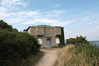
The fort du Mengant or fort du Léon in the commune of Plouzané is part of the defences of the roadstead of Brest. It is made up of a high battery, with a now-destroyed artillery tower, and a lower semi-circular battery at the foot of the cliff, with two small powder magazines.
The batteries de Kerviniou are artillery batteries built in the late 19th and early 20th centuries, and are made up of an upper battery (1891) and an underground magazine (1891) Located on the Roscanvel peninsula facing the Fort du Mengant, they are a late addition to the defences of the goulet de Brest. Demilitarised in 1915, they are open to the public.

The Fort de Portzic was built near the town of Brest by Vauban between 1693 and 1699 as part of the defences of the goulet de Brest. It faces the pointe des Espagnols and was improved and enlarged over time, since it formed the town's last and innermost defence. The buildings on the site remain in military use. Nearby is the lighthouse Phare du Portzic.

The Pointe des Espagnols is the north-east extremity of the Roscanvel peninsula, an outgrowth of the Crozon peninsula closing off the roadstead of Brest. It also marks the south-east limit of the goulet de Brest.

Îlot des Capucins is a rocky islet at the foot of a cliff in the commune of Roscanvel on the Crozon peninsula. Its name comes from a rock near the island, shaped like a praying monk. It has a strategic position at the entrance to the goulet de Brest and so a fort sited on it controlled the whole of Camaret Bay, with views stretching from pointe du Grand Gouin, to fort de Bertheaume.

A model tower (tour-modèle), also known as an Empire tower or a Napoleon tower, was a standardised defensive fortification created in 1811. Construction began along the Atlantic and Mediterranean coastlines the following year but the project was abandoned in 1814 with only 12 towers being completed.
The crenellated guardhouses of the 1846 model were gun-batteries built along the coast of France as the result of a standardisation of coastal-defence redoubts during the reign of Louis Philippe I. This standardisation came as an attempt to complete the defensive chain begun by Napoleon in 1811 with his model towers, left incomplete on his abdication in 1814. A mixed coastal armament commission set up in 1841 defined 3 types of work, known as crenellated guardhouses, crenellated towers and model-redoubt with defensive barracks. Along with the construction of the battleship La Gloire, they represent part of a 20-year trend of French naval and coastal re-armament, to which the United Kingdom eventually responded by building its own steam battleship (Warrior) and its own coastal defence chain during the 1860s.

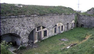
Îlot du Diable is a gun battery built to support fort de la Fraternité in the defensive system around the goulet de Brest in France. It is sited on the peninsula of Roscanvel and is accessible by a small bridge. The battery was razed in the 19th century, and in 1890 on its site was built a bunker with an electricity generator. A casemate was then added by the Germans in 1942. A small observation is still to be found at the summit of the site, near a former lime kiln.
Quélern is a hamlet in Roscanvel, in the department of Finistère (Brittany), in western France.
Tremet is a hamlet on the Roscanvel peninsula in France. The gun batteries located here are part of the defences of the goulet de Brest, forbidding ships from entering the bay of Camaret-sur-Mer. The site had been occupied by the military since 1694 and was updated several times in the 18th and 19th centuries. The battery became a heavy anti-aircraft post in 1955 as part of the outer defences of Brest's military fort - part of that battery is still part of the military land around Quélern and not open to the public.

The pointe du Grand Gouin is a rocky promontory with vertical cliffs to the west of the inlet of Camaret-sur-Mer in France. It protects a port which, in Vauban's era, was vulnerable to possible landings. It is divided into the Grand Gouin and the Petit Gouin (mid-cliff).
Kerbonn is a village in the commune of Camaret-sur-Mer in France, between the pointe de Pen-Hir and the pointe du Toulinguet, on the Crozon peninsula. As well as its fortifications, the site also houses the ruins of the manor of Coecilian.

The Pointe du Toulinguet is a promontory at the end of the Crozon peninsula in the commune of Camaret-sur-Mer in France, in western Brittany.

Fort de Villey-le-Sec, also known as Fort Trévise, is a fortification of the 19th century, built as part of the Séré de Rivières system of fortifications in Villey-le-Sec, France, one of the defenses of Toul. It is a unique example for its time of a defensive enclosure around a village. Conceived after the defeat of the Franco-Prussian War of 1870-71, the fort was located away from the main combat zone of World War I and has remained almost intact. The fort's preservation association has been at work since 1961 to restore and interpret the site. It has been included in the Inventory of Historic Sites and has been designated as a preserved natural area.

The Fort des Ayvelles, also known as the Fort Dubois-Crancé, is a fortification near the French communes of Villers-Semeuse and Les Ayvelles in the Ardennes, just to the south of Charleville-Mézières. As part of the Séré de Rivières system of fortifications, the fort was planned as part of a new ring of forts replacing the older citadel of Mézières with dispersed fortifications. With advances in the range and destructive power of artillery, the city's defensive perimeter had to be pushed away from the city center to the limits of artillery range. The Fort des Ayvelles was the only such fortification to be completed of the ensemble, as resources were diverted elsewhere. At the time of its construction the fort controlled the Meuse and the railway line linking Reims, Montmédy, Givet and Hirson. The Fort des Ayvelles was reduced in status in 1899, its masonry construction rendered obsolete by the advent of high-explosive artillery shells. However, it was re-manned for the First World War before it was captured by the Germans on 29 August 1914. The fort was partly destroyed in 1918. During the Battle of France in 1940 the fort was bombarded. French resisters were executed at Ayvelles during both world wars. At present the fort is maintained by a preservation society, and may be visited.
References
- ↑ Michel Dion (1996). Batteries, réduits, tours, forts, casemates... de Camaret et Roscanvel (in French). Brest: Association du Mémorial Montbarey. p. 67.