Grand Gouin
In 1693, Vauban began to organise the defences of Brest with batteries and fortifications all along the Camaret bay, from the pointe du Gouin to the Quélern lines (Louis XIV of France had been warned of an Anglo-Dutch attack in the area, but did not know its precise landing point). In 1695 a mortar battery was set up on the Grand Gouin, though its location is now unknown. [1] These mortar batteries could be directed towards the Cameret inlet and crossed their field of fire with those at Tremet, as well as covering the goulet de Brest to harry an approaching enemy. [1]
The Germans built a platform for four 220mm Schneider guns on a new site here between 1942 and 1943, known as Camaret battery and manned by the 1/1274 HKAA (Heeres-Küsten-Artillerie-Abteilung). This had a range of 22 km and formed the most important coastal defence for the Crozon peninsula. It was made up of four batteries (one gun each), each accompanied by four bunkers, as well as a fire-direction point and many anti-aircraft guns. [1]
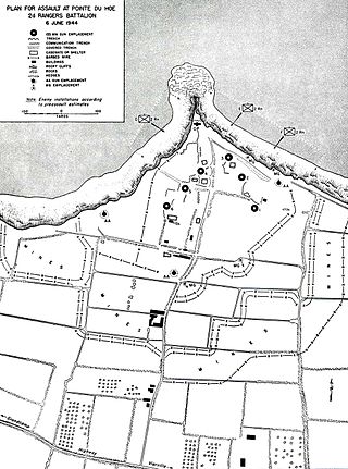
La Pointe du Hoc is a promontory with a 35-metre (110 ft) cliff overlooking the English Channel on the northwestern coast of Normandy in the Calvados department, France.

The Battle of Camaret, also referred to as the Brest expedition, was a notable engagement of the Nine Years' War. Expecting Brest to be unguarded as the French fleet stationed there sailed south to face the Spanish, an amphibious operation at Camaret Bay was launched on 18 June 1694 by a 10,000 to 12,000-strong Anglo-Dutch force in an attempt to take and occupy the city, which represented one of the most important French naval bases. The French, however, were well aware of their plan.

Île Longue is a peninsula of the roadstead of Brest in the department of Finistère in the Brittany region. It is the base of the French nuclear ballistic missile submarines, and as such one of the most secretive and heavily defended places in France.
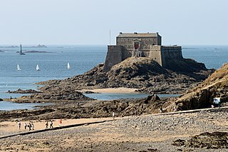
Petit Bé is a tidal island near the city of Saint-Malo, France, close to the larger island of Grand Bé. At low tide one can walk to the island from the nearby Bon-Secours beach.
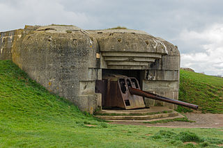
The Longues-sur-Mer battery is a World War II German coastal artillery battery approximately 1 km (0.62 mi) north of the village of Longues-sur-Mer in Normandy, France. The battery is sited on a 60 m (200 ft) cliff overlooking the Baie de Seine and formed a part of Germany's Atlantic Wall coastal fortifications, between the Allied landing sectors of Gold Beach and Omaha Beach.

The Goulet de Brest is a 3-km-long strait linking the roadstead of Brest to the Atlantic Ocean. Only 1.8 km wide, the goulet is situated between the Pointe du Petit Minou and the Pointe du Portzic to the north and the îlot des Capucins and the Pointe des Espagnols to the south.

The Fort de Bertheaume is a fort in Plougonvelin, in the Department of Finistère, France. It is located on a tidal island that nowadays connects to the mainland via a footbridge. The fort sits well above sea level, and its steep cliffs have rendered it easily defended for centuries. Since the 17th century, the fort's role has been to monitor the Goulet de Brest, the straits of Brest.
La pointe de Cornouaille is a cape to the north of the hamlet of Kerviniou in France. They are both situated on the Roscanvel peninsula and, facing as it does the Fort du Mengant, a battery on the point forms part of the defences of the goulet de Brest. Known defences on the site include:
The batteries de Kerviniou are artillery batteries built in the late 19th and early 20th centuries, and are made up of an upper battery (1891) and an underground magazine (1891) Located on the Roscanvel peninsula facing the Fort du Mengant, they are a late addition to the defences of the goulet de Brest. Demilitarised in 1915, they are open to the public.

The Pointe des Espagnols is the north-east extremity of the Roscanvel peninsula, an outgrowth of the Crozon peninsula closing off the roadstead of Brest. It also marks the south-east limit of the goulet de Brest.

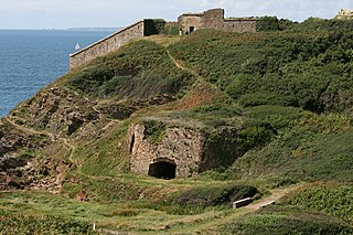
Îlot des Capucins is a rocky islet at the foot of a cliff in the commune of Roscanvel on the Crozon peninsula. Its name comes from a rock near the island, shaped like a praying monk. It has a strategic position at the entrance to the goulet de Brest and so a fort sited on it controlled the whole of Camaret Bay, with views stretching from pointe du Grand Gouin, to fort de Bertheaume.

A model tower (tour-modèle), also known as an Empire tower or a Napoleon tower, was a standardised defensive fortification created in 1811. Construction began along the Atlantic and Mediterranean coastlines the following year but the project was abandoned in 1814 with only 12 towers being completed.
The crenellated guardhouses of the 1846 model were gun-batteries built along the coast of France as the result of a standardisation of coastal-defence redoubts during the reign of Louis Philippe I. This standardisation came as an attempt to complete the defensive chain begun by Napoleon in 1811 with his model towers, left incomplete on his abdication in 1814. A mixed coastal armament commission set up in 1841 defined 3 types of work, known as crenellated guardhouses, crenellated towers and model-redoubt with defensive barracks. Along with the construction of the battleship La Gloire, they represent part of a 20-year trend of French naval and coastal re-armament, to which the United Kingdom eventually responded by building its own steam battleship (Warrior) and its own coastal defence chain during the 1860s.
The Fort de la Fraternité is a fort located on the îlot du Diable in Roscanvel, France. The whole complex is now in ruins, though a gunpowder magazine is still standing, with a roof of large rectangular tiles and elaborate guttering.

Îlot du Diable is a gun battery built to support fort de la Fraternité in the defensive system around the goulet de Brest in France. It is sited on the peninsula of Roscanvel and is accessible by a small bridge. The battery was razed in the 19th century, and in 1890 on its site was built a bunker with an electricity generator. A casemate was then added by the Germans in 1942. A small observation is still to be found at the summit of the site, near a former lime kiln.
Quélern is a hamlet in Roscanvel, in the department of Finistère (Brittany), in western France.
Tremet is a hamlet on the Roscanvel peninsula in France. The gun batteries located here are part of the defences of the goulet de Brest, forbidding ships from entering the bay of Camaret-sur-Mer. The site had been occupied by the military since 1694 and was updated several times in the 18th and 19th centuries. The battery became a heavy anti-aircraft post in 1955 as part of the outer defences of Brest's military fort - part of that battery is still part of the military land around Quélern and not open to the public.

The Tour Vauban, initially known as the tour de Camaret, is an 18m-high polygonal defensive tower built to a plan by Vauban on the Sillon at Camaret-sur-Mer, as part of the fortifications of the goulet de Brest. It has three levels and is flanked by walls, a guardhouse and a gun battery which can hold 11 cannons as well as a cannonball foundry added in the French Revolution period.
Kerbonn is a village in the commune of Camaret-sur-Mer in France, between the pointe de Pen-Hir and the pointe du Toulinguet, on the Crozon peninsula. As well as its fortifications, the site also houses the ruins of the manor of Coecilian.

The Pointe du Toulinguet is a promontory at the end of the Crozon peninsula in the commune of Camaret-sur-Mer in France, in western Brittany.
